Difference between revisions of "White"
(Created page with "<div id="content_view" class="wiki" style="display: block"> =White= {| class="wiki_table" | Lat: 44.6°S, Long: 158.3°W, Diam: 39 km, Depth: km, Rükl: ''(farside)'', [/S...") |
|||
| Line 3: | Line 3: | ||
{| class="wiki_table" | {| class="wiki_table" | ||
| | | | ||
| − | Lat: 44.6°S, Long: 158.3°W, Diam: 39 km, Depth: km, Rükl: ''(farside)'', [ | + | Lat: 44.6°S, Long: 158.3°W, Diam: 39 km, Depth: km, Rükl: ''(farside)'', [[Stratigraphy|Upper Imbrian]]<br /> |
|} | |} | ||
<div id="toc"> | <div id="toc"> | ||
| Line 11: | Line 11: | ||
[http://www.lpod.org/coppermine/thumbnails.php?album=search&type=full&search=White LPOD Photo Gallery] [http://www.lpi.usra.edu/resources/lunar_orbiter/bin/srch_nam.shtml?White%7C0 Lunar Orbiter Images] [http://www.lpi.usra.edu/resources/apollo/search/feature/?feature=White Apollo Images]<br /> <br /> | [http://www.lpod.org/coppermine/thumbnails.php?album=search&type=full&search=White LPOD Photo Gallery] [http://www.lpi.usra.edu/resources/lunar_orbiter/bin/srch_nam.shtml?White%7C0 Lunar Orbiter Images] [http://www.lpi.usra.edu/resources/apollo/search/feature/?feature=White Apollo Images]<br /> <br /> | ||
==Maps== | ==Maps== | ||
| − | ''([ | + | ''([[LAC%20zone|LAC zone]] 120C3)'' [http://planetarynames.wr.usgs.gov/images/Lunar/lac_120.pdf USGS Digital Atlas PDF]<br /> <br /> |
==Description== | ==Description== | ||
<br /> | <br /> | ||
| Line 17: | Line 17: | ||
[http://en.wikipedia.org/wiki/White_(crater) White]<br /> <br /> | [http://en.wikipedia.org/wiki/White_(crater) White]<br /> <br /> | ||
==Additional Information== | ==Additional Information== | ||
| − | * [ | + | * [[Central%20peak%20composition|Central peak composition]]: GNTA2, AG, AN, GN ([[Tompkins%20%26%20Pieters%2C%201999|Tompkins & Pieters, 1999]]) |
* Concentric Crater (CC) southwest of '''White W''' ? See''':''' http://bit.ly/2DTGvFl | * Concentric Crater (CC) southwest of '''White W''' ? See''':''' http://bit.ly/2DTGvFl | ||
<br /> | <br /> | ||
Revision as of 16:22, 15 April 2018
Contents
White
|
Lat: 44.6°S, Long: 158.3°W, Diam: 39 km, Depth: km, Rükl: (farside), Upper Imbrian |
Table of Contents
[#White White]
[#White-Images Images]
[#White-Maps Maps]
[#White-Description Description]
[#White-Description: Wikipedia Description: Wikipedia]
[#White-Additional Information Additional Information]
[#White-Nomenclature Nomenclature]
[#White-LPOD Articles LPOD Articles]
[#White-Bibliography Bibliography]


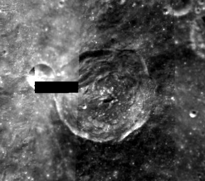
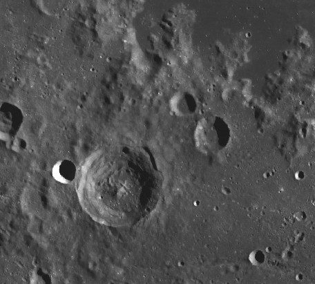
left: Clementine .right: LROC . Apollo basin dark floor at top right
Images
LPOD Photo Gallery Lunar Orbiter Images Apollo Images
Maps
(LAC zone 120C3) USGS Digital Atlas PDF
Description
Description: Wikipedia
Additional Information
- Central peak composition: GNTA2, AG, AN, GN (Tompkins & Pieters, 1999)
- Concentric Crater (CC) southwest of White W ? See: http://bit.ly/2DTGvFl
Nomenclature
- Edward Higgins White II (November 14, 1930 - January 27, 1967) was a United States Air Force officer and a NASA astronaut. On June 3, 1965, he became the first American to conduct a spacewalk. White was killed during the Apollo 1 training accident and posthumously awarded the Congressional Space Medal of Honor and the Purple Heart Medal.
  - On the farside map of Hallwag, the name White was erroneously printed at the location of crater Grissom.- DannyCaes DannyCaes Jun 19, 2010
LPOD Articles
Bibliography
-Edward White, Gemini 4:
 AMERICA'S 6,000-MILE WALK IN SPACE, pages 440-447 in NATIONAL GEOGRAPHIC september 1965.
This page has been edited 1 times. The last modification was made by - tychocrater tychocrater on Jun 13, 2009 3:24 pm - afx3u2