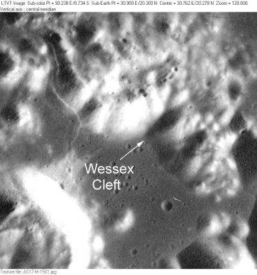
Wessex Cleft
Contents
Wessex Cleft (Apollo 17 site formation name)
|
Lat: 20.3°N, Long: 30.9°E, Diam: 4 km, Depth: km, [/R%C3%BCkl%2025 Rükl: 25] |
Table of Contents
[#Wessex Cleft (Apollo 17 site formation name) Wessex Cleft (Apollo 17 site formation name)]
[#Wessex Cleft (Apollo 17 site formation name)-Images Images]
[#Wessex Cleft (Apollo 17 site formation name)-Sunrise circumstances at the Wessex Cleft and the western part of the Sculptured Hills Sunrise circumstances at the Wessex Cleft and the western part of the Sculptured Hills]
[#Wessex Cleft (Apollo 17 site formation name)-Maps Maps]
[#Wessex Cleft (Apollo 17 site formation name)-Description Description]
[#Wessex Cleft (Apollo 17 site formation name)-Description: Wikipedia Description: Wikipedia]
[#Wessex Cleft (Apollo 17 site formation name)-Additional Information Additional Information]
[#Wessex Cleft (Apollo 17 site formation name)-Nomenclature Nomenclature]
[#Wessex Cleft (Apollo 17 site formation name)-LPOD Articles LPOD Articles]
[#Wessex Cleft (Apollo 17 site formation name)-Bibliography Bibliography]

AS17-M-1501
Images
LPOD Photo Gallery Lunar Orbiter Images Apollo Images
Mike Constantine's assembled panorama of LM Challenger's landingsite shows the flag, CDR Gene Cernan and the Lunar Roving Vehicle in front of the Wessex Cleft. The North Massif at left of it, the Sculptured Hills and the East Massif behind (and rightward) of LM Challenger. Looking east.
AS17-134-20431 is one of Apollo 17's many LEVA-Hasselblad photographs of the shadowed Wessex Cleft between the North Massif (left) and the Sculptured Hills (right). - DannyCaes DannyCaes Jan 26, 2008
Sunrise circumstances at the Wessex Cleft and the western part of the Sculptured Hills
- A survey of surface photographs made by Gene Cernan and Jack Schmitt (Apollo 17, december 1972)
- The first photographs were made at sun's elevation 16 degrees, the last ones at sun's elevation 38 degrees
- Research: Danny Caes (- DannyCaes DannyCaes May 1, 2014)
EVA 1
- AS17-147-22505 (photographed from Station LM, EVA 1).
- AS17-147-22530, 22537, 22552, and 22563 (photographed from the ALSEP station, EVA 1).
- AS17-147-22577 (photographed from the ALSEP station, part of the LRV, EVA 1).
- AS17-147-22599 and 22600 (photographed from the ALSEP station, Gene Cernan drilling, EVA 1).
- AS17-136-20695 (photographed from the ALSEP station, Gene Cernan extracting core, EVA 1).
- AS17-134-20408 and 20431 (photographed from Station 1 near Steno-Apollo crater, EVA 1).
- AS17-136-20758 (photographed from Station 1 near Steno-Apollo crater, Gene Cernan at the LRV, EVA 1).
- AS17-136-20782, 20803, and 20815 (photographed during LRV traverse from Station 1 to Station SEP, EVA 1).
EVA 2
- AS17-137-20876 (photographed from Station LM, EVA 2).
- AS17-135-20568 (photographed during LRV traverse from Station SEP to Station 2, EVA 2).
- AS17-138-21039 (photographed from Station 2 near Nansen-Apollo crater, EVA 2).
- AS17-138-21077 and 21095 (photographed during LRV traverse from Station 2 to Station 2A, EVA 2).
- AS17-138-21113 (photographed during LRV traverse from Station 2A to Station 3, EVA 2).
- AS17-138-21165 (photographed from Station 3 near Lara crater, EVA 2).
- AS17-133-20196, 20202, 20217, 20224, 20226, and 20227 (photographed during LRV traverse from Station 3 to Station 4, EVA 2).
- AS17-133-20242 (photographed at Station 4 near Shorty crater, EVA 2).
- AS17-133-20272, 20275, 20298, and 20321 (photographed during LRV traverse from Station 4 to Station 5, EVA 2).
- AS17-133-20347 (photographed from Station 5 near Camelot crater, EVA 2).
- AS17-145-22159 and 22160 (photographed from Station 5 at the boulder field near Camelot crater, EVA 2).
- AS17-133-20363 (photographed during LRV traverse from Station 5 to Station LM, EVA 2).
EVA 3
- AS17-140-21368 (photographed from Station LM, Jack Schmitt at the LRV, US flag, EVA 3).
- AS17-140-21388 (photographed from Station LM, Gene Cernan at the LRV, US flag, EVA 3).
- AS17-141-21520 (photographed during LRV traverse from Sation SEP to Station 6, EVA 3).
- During the explorations of stations 6, 7, and 8 on the slopes of the North Massif, the Wessex Cleft and the Sculptured Hills were much too nearby and "frame filling" to recognize them.
- AS17-142-21813 (photographed from Station 9, Gene Cernan near Van Serg crater, EVA 3).
- AS17-143-21840 and 21841 (photographed from Station 9, EVA 3).
- AS17-146-22436, 22437, and 22438 (photographed from Station 9, EVA 3).
Maps
([/LAC%20zone LAC zone] 43D1) LAC map Geologic map LTO map
Description
Description: Wikipedia
Additional Information
The [/Landing%20Site%20Name Landing Site Name] "Wessex Cleft" is plotted on Topophotomap 43D1/S1 and on Site Traverses chart 43D1S2.
- Wessex Cleft (dividing the North Massif from the Sculptured Hills) - "Wessex, with its deep-rooted place in the far history of England and in the novels of Thomas Hardy, symbolizes the intangible strength that the land transmits to its people the world over. People have always been in transit from the land or to the land; now, space has offered the awesome possibility of final separation." (source: APOLLO LUNAR SURFACE JOURNAL, Eric M. Jones).
- Note that this is not a "cleft" in the sense normally used by [/Elger%2C%201895 Elger] in his feature descriptions -- that is, it is not a rille, but rather simply an indentation separating two separately named mountain units: [/North%20Massif North Massif], on the northwest, from [/Sculptured%20Hills Sculptured Hills], on the southeast.
Nomenclature
Astronaut-named feature, [/Apollo%2017%20site Apollo 17 site].
LPOD Articles
Bibliography
EXPLORING THE MOON; The Apollo Expeditions (David M. Harland, Springer - 1999).
This page has been edited 1 times. The last modification was made by - tychocrater tychocrater on Jun 13, 2009 3:24 pm - afx3u2