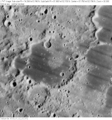
Ulugh Beigh
Contents
Ulugh Beigh
|
Lat: 32.7°N, Long: 81.9°W, Diam: 54 km, Depth: 0.58 km, [/R%C3%BCkl%208 Rükl: 8] |
Table of Contents
[#Ulugh Beigh Ulugh Beigh]
[#Ulugh Beigh-Images Images]
[#Ulugh Beigh-Maps Maps]
[#Ulugh Beigh-Description Description]
[#Ulugh Beigh-Description: Elger Description: Elger]
[#Ulugh Beigh-Description: Wikipedia Description: Wikipedia]
[#Ulugh Beigh-Additional Information Additional Information]
[#Ulugh Beigh-Nomenclature Nomenclature]
[#Ulugh Beigh-LPOD Articles LPOD Articles]
[#Ulugh Beigh-Bibliography Bibliography]

LO-IV-189H Ulugh Beigh is the dark-floored area in the center. In the upper right corner one can see a southern extension out of the similarly dark-floored 41-km Ulugh Beigh A. The 21-km depression just outside the southwest rim of Ulugh Beigh is Ulugh Beigh D.
Images
LPOD Photo Gallery Lunar Orbiter Images Apollo Images
Maps
([/LAC%20zone LAC zone] 22D4) USGS Digital Atlas PDF
Description
Description: Elger
([/IAU%20Directions IAU Directions]) ULUGH BEIGH.--A good-sized ring-plain, W. of [/Lichtenberg Lichtenberg], with a bright border and central mountain. Too near the limb for observation.
Description: Wikipedia
Additional Information
Depth data from [/Kurt%20Fisher%20crater%20depths Kurt Fisher database]
- Westfall, 2000: 0.58 km
- Cherrington, 1969: 1.7 km
Ulugh Beigh A has a neat zig-zaggy sinuous rille on the ESE part of its floor, see: http://bit.ly/2CqdfFC
Nomenclature
Ulugh-Beg; Mongolian astronomer, mathematician (1394-1449).
- According to [/Whitaker Whitaker] (p. 219), this name was introduced by [/M%C3%A4dler Mädler]. Also according to [/Whitaker Whitaker] (p. 235), due to ambiguities in the map of [/Blagg%20and%20M%C3%BCller Blagg and Müller], the boundaries of the feature were re-drawn in the 1960's. - JimMosher JimMosher
- Printed as Ulugh Biegh on the revised and reprinted edition of the National Geographic Society's map THE EARTH'S MOON. - DannyCaes DannyCaes Oct 8, 2015 (selenography's nitpicker).
LPOD Articles
Bibliography
This page has been edited 1 times. The last modification was made by - tychocrater tychocrater on Jun 13, 2009 3:24 pm - afx3u2