Difference between revisions of "Stearns"
(Created page with "<div id="content_view" class="wiki" style="display: block"> =Stearns= {| class="wiki_table" | Lat: 34.63°N, Long: 162.5°E, Diam: 37.65 km, Depth: km, Rükl: ''(farside)'...") |
|||
| (2 intermediate revisions by the same user not shown) | |||
| Line 3: | Line 3: | ||
{| class="wiki_table" | {| class="wiki_table" | ||
| | | | ||
| − | Lat: 34.63°N, Long: 162.5°E, Diam: 37.65 km, Depth: km, Rükl: ''(farside)'', [ | + | Lat: 34.63°N, Long: 162.5°E, Diam: 37.65 km, Depth: km, Rükl: ''(farside)'', [[Stratigraphy|Eratosthenian]]<br /> |
|} | |} | ||
<div id="toc"> | <div id="toc"> | ||
| − | + | [http://www.lpod.org/coppermine/displayimage.php?pid=5028&fullsize=1 [[Image:Normal_stearns.jpg|external image normal_stearns.jpg]]]<br /> ''[http://lroc.sese.asu.edu/index.html LROC]'' WAC image No. [http://wms.lroc.asu.edu/lroc/view_lroc/LRO-L-LROC-2-EDR-V1.0/M118791271ME M118791271ME]. Calibrated by [http://ltvt.wikispaces.com/Utility+Programs#WAC_Viewer LROC_WAC_Previewer].<br /> <br /> | |
| − | |||
==Images== | ==Images== | ||
[http://www.lpod.org/coppermine/thumbnails.php?album=search&type=full&search=Stearns LPOD Photo Gallery] [http://www.lpi.usra.edu/resources/lunar_orbiter/bin/srch_nam.shtml?Stearns%7C0 Lunar Orbiter Images] [http://www.lpi.usra.edu/resources/apollo/search/feature/?feature=Stearns Apollo Images]<br /> <br /> | [http://www.lpod.org/coppermine/thumbnails.php?album=search&type=full&search=Stearns LPOD Photo Gallery] [http://www.lpi.usra.edu/resources/lunar_orbiter/bin/srch_nam.shtml?Stearns%7C0 Lunar Orbiter Images] [http://www.lpi.usra.edu/resources/apollo/search/feature/?feature=Stearns Apollo Images]<br /> <br /> | ||
==Maps== | ==Maps== | ||
| − | ''([ | + | ''([[LAC%20zone|LAC zone]] 32D3)'' [http://planetarynames.wr.usgs.gov/images/Lunar/lac_32.pdf USGS Digital Atlas PDF]<br /> <br /> |
==Description== | ==Description== | ||
<br /> | <br /> | ||
| Line 18: | Line 17: | ||
==Additional Information== | ==Additional Information== | ||
* IAU page: [http://planetarynames.wr.usgs.gov/Feature/5685 Stearns] | * IAU page: [http://planetarynames.wr.usgs.gov/Feature/5685 Stearns] | ||
| − | * Exterior impact melt deposits most extensive to NNE, max of ~25 km beyond rim. Max wall slumping on N side of crater, and topographically lowest rim crest to SE ([ | + | * Exterior impact melt deposits most extensive to NNE, max of ~25 km beyond rim. Max wall slumping on N side of crater, and topographically lowest rim crest to SE ([[Hawke%20and%20Head%2C%201977|Hawke and Head, 1977]]). |
<br /> | <br /> | ||
==Nomenclature== | ==Nomenclature== | ||
| Line 27: | Line 26: | ||
<br /> <br /> | <br /> <br /> | ||
---- | ---- | ||
| − | [ | + | [[Alphabetical%20Index|Named Features]] -- Prev: [[Statio%20Tranquillitatis|Statio Tranquillitatis]] -- Next: [[Stebbins|Stebbins]]<br /> |
---- | ---- | ||
| − | + | </div> | |
Latest revision as of 03:18, 16 April 2018
Contents
Stearns
|
Lat: 34.63°N, Long: 162.5°E, Diam: 37.65 km, Depth: km, Rükl: (farside), Eratosthenian |

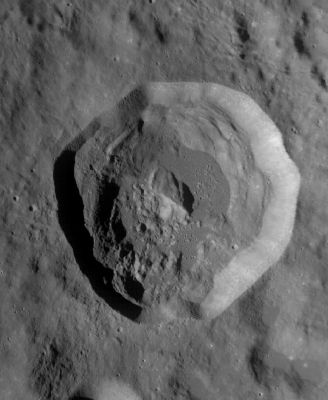
LROC WAC image No. M118791271ME. Calibrated by LROC_WAC_Previewer.
Images
LPOD Photo Gallery Lunar Orbiter Images Apollo Images
Maps
(LAC zone 32D3) USGS Digital Atlas PDF
Description
Wikipedia
Additional Information
- IAU page: Stearns
- Exterior impact melt deposits most extensive to NNE, max of ~25 km beyond rim. Max wall slumping on N side of crater, and topographically lowest rim crest to SE (Hawke and Head, 1977).
Nomenclature
Carl Leo; American astronomer (1892-1972).
LPOD Articles
Bibliography
Named Features -- Prev: Statio Tranquillitatis -- Next: Stebbins