Difference between revisions of "Segers"
(Created page with "<div id="content_view" class="wiki" style="display: block"> =Segers= {| class="wiki_table" | Lat: 47.1°N, Long: 127.7°E, Diam: 17 km, Depth: km, Rükl: ''(farside)'', [h...") |
|||
| Line 3: | Line 3: | ||
{| class="wiki_table" | {| class="wiki_table" | ||
| | | | ||
| − | Lat: 47.1°N, Long: 127.7°E, Diam: 17 km, Depth: km, Rükl: ''(farside)'', [http://the-moon. | + | Lat: 47.1°N, Long: 127.7°E, Diam: 17 km, Depth: km, Rükl: ''(farside)'', [http://the-moon.us/wiki/Stratigraphy Copernican]<br /> |
|} | |} | ||
<div id="toc"> | <div id="toc"> | ||
| Line 11: | Line 11: | ||
[http://www.lpod.org/coppermine/thumbnails.php?album=search&type=full&search=Segers LPOD Photo Gallery] [http://www.lpi.usra.edu/resources/lunar_orbiter/bin/srch_nam.shtml?Segers%7C0 Lunar Orbiter Images] [http://www.lpi.usra.edu/resources/apollo/search/feature/?feature=Segers Apollo Images]<br /> '''Segers''' and '''Segers H''' were captured on several photographs made by Apollo 16's ''Fairchild''-camera, this during Trans Earth Coast (TEC).<br /> One of those photographs ([http://www.lpi.usra.edu/resources/apollo/frame/?AS16-M-3021 AS16-M-3021]) shows both '''Segers''' and '''Segers H''' near the frame's lower margin (very near the terminator).<br /> Research: Danny Caes<br /> <br /> | [http://www.lpod.org/coppermine/thumbnails.php?album=search&type=full&search=Segers LPOD Photo Gallery] [http://www.lpi.usra.edu/resources/lunar_orbiter/bin/srch_nam.shtml?Segers%7C0 Lunar Orbiter Images] [http://www.lpi.usra.edu/resources/apollo/search/feature/?feature=Segers Apollo Images]<br /> '''Segers''' and '''Segers H''' were captured on several photographs made by Apollo 16's ''Fairchild''-camera, this during Trans Earth Coast (TEC).<br /> One of those photographs ([http://www.lpi.usra.edu/resources/apollo/frame/?AS16-M-3021 AS16-M-3021]) shows both '''Segers''' and '''Segers H''' near the frame's lower margin (very near the terminator).<br /> Research: Danny Caes<br /> <br /> | ||
==Maps== | ==Maps== | ||
| − | ''([http://the-moon. | + | ''([http://the-moon.us/wiki/LAC%20zone LAC zone] 30B2)'' [http://planetarynames.wr.usgs.gov/images/Lunar/lac_30.pdf USGS Digital Atlas PDF]<br /> <br /> |
==Description== | ==Description== | ||
<br /> | <br /> | ||
Revision as of 20:31, 11 April 2018
Contents
Segers
|
Lat: 47.1°N, Long: 127.7°E, Diam: 17 km, Depth: km, Rükl: (farside), Copernican |
Table of Contents
[#Segers Segers]
[#Segers-Images Images]
[#Segers-Maps Maps]
[#Segers-Description Description]
[#Segers-Description: Wikipedia Description: Wikipedia]
[#Segers-Additional Information Additional Information]
[#Segers-Nomenclature Nomenclature]
[#Segers-LPOD Articles LPOD Articles]
[#Segers-Bibliography Bibliography]

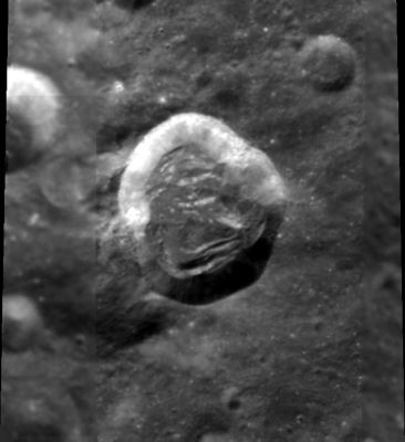
Clementine. Segers is the crater half shown at upper left, Segers H is the larger crater in the center of view.
Images
LPOD Photo Gallery Lunar Orbiter Images Apollo Images
Segers and Segers H were captured on several photographs made by Apollo 16's Fairchild-camera, this during Trans Earth Coast (TEC).
One of those photographs (AS16-M-3021) shows both Segers and Segers H near the frame's lower margin (very near the terminator).
Research: Danny Caes
Maps
(LAC zone 30B2) USGS Digital Atlas PDF
Description
Description: Wikipedia
Additional Information
Nomenclature
Carlos; Argentinean astronomer (1900-1967).
LPOD Articles
Bibliography
This page has been edited 1 times. The last modification was made by - tychocrater tychocrater on Jun 13, 2009 3:24 pm - afx3u2