Difference between revisions of "Plum"
(Created page with "<div id="content_view" class="wiki" style="display: block"> =Plum (Apollo 16 site craterlet name)= {| class="wiki_table" | Lat: 9.0°S, Long: 15.5°E, Diam: 0.04 km, Depth...") |
|||
| Line 3: | Line 3: | ||
{| class="wiki_table" | {| class="wiki_table" | ||
| | | | ||
| − | Lat: 9.0°S, Long: 15.5°E, Diam: 0.04 km, Depth: km, [http://the-moon. | + | Lat: 9.0°S, Long: 15.5°E, Diam: 0.04 km, Depth: km, [http://the-moon.us/wiki/R%C3%BCkl%2045 Rükl: 45]<br /> |
|} | |} | ||
| − | [[Image:a16.plum_pan.jpg|external image a16.plum_pan.jpg]]<br /> ''- [http://www.history.nasa.gov/alsj/a16/a16.sta1.html Apollo 16 Surface Journal]'' At the time of the Apollo 16 landing, surface shadows at this site would have pointed essentially due west. Hence this photo appears to have been taken looking south. The hill on the left is probably [http://the-moon. | + | [[Image:a16.plum_pan.jpg|external image a16.plum_pan.jpg]]<br /> ''- [http://www.history.nasa.gov/alsj/a16/a16.sta1.html Apollo 16 Surface Journal]'' At the time of the Apollo 16 landing, surface shadows at this site would have pointed essentially due west. Hence this photo appears to have been taken looking south. The hill on the left is probably [http://the-moon.us/wiki/Stone%20Mountain Stone Mountain], and the light area in the distance beyond '''Plum''' is presumably the bright ejecta blanket around [http://the-moon.us/wiki/South%20Ray South Ray] crater. A small part of the lip of [http://the-moon.us/wiki/Flag Flag] crater is visible on the extreme right, as can be seen a [http://www.history.nasa.gov/alsj/a16/a16pan1232508.jpg larger panorama] involving this frame.<br /> - [http://www.hq.nasa.gov/office/pao/History/alsj/a16/a16-17789det.jpg Detail] of the '''Plum''' panorama above shows the location of the legendary rock called [http://www.hq.nasa.gov/office/pao/History/alsj/a16/ap16-S72-41841.jpg Big Muley] (which is the largest one of all the rocks collected during the entire Apollo program!).<br /> - [http://www.hq.nasa.gov/office/pao/History/alsj/a16/AS16-109-17789HR.jpg Hi-Res scan] of the detail photograph in the '''Plum''' panorama ('''Big Muley''''s location).<br /> Source''':''' ''Apollo Lunar Surface Journal'' (''ALSJ''), and ''Project Apollo Archive''.<br /> <br /> <div id="toc"> |
=Table of Contents= | =Table of Contents= | ||
<div style="margin-left: 1em">[#Plum (Apollo 16 site craterlet name) Plum (Apollo 16 site craterlet name)]</div><div style="margin-left: 2em">[#Plum (Apollo 16 site craterlet name)-Images Images]</div><div style="margin-left: 2em">[#Plum (Apollo 16 site craterlet name)-Maps Maps]</div><div style="margin-left: 2em">[#Plum (Apollo 16 site craterlet name)-Description Description]</div><div style="margin-left: 2em">[#Plum (Apollo 16 site craterlet name)-Description: Wikipedia Description: Wikipedia]</div><div style="margin-left: 2em">[#Plum (Apollo 16 site craterlet name)-Additional Information Additional Information]</div><div style="margin-left: 2em">[#Plum (Apollo 16 site craterlet name)-Nomenclature Nomenclature]</div><div style="margin-left: 2em">[#Plum (Apollo 16 site craterlet name)-LPOD Articles LPOD Articles]</div><div style="margin-left: 2em">[#Plum (Apollo 16 site craterlet name)-Bibliography Bibliography]</div></div> | <div style="margin-left: 1em">[#Plum (Apollo 16 site craterlet name) Plum (Apollo 16 site craterlet name)]</div><div style="margin-left: 2em">[#Plum (Apollo 16 site craterlet name)-Images Images]</div><div style="margin-left: 2em">[#Plum (Apollo 16 site craterlet name)-Maps Maps]</div><div style="margin-left: 2em">[#Plum (Apollo 16 site craterlet name)-Description Description]</div><div style="margin-left: 2em">[#Plum (Apollo 16 site craterlet name)-Description: Wikipedia Description: Wikipedia]</div><div style="margin-left: 2em">[#Plum (Apollo 16 site craterlet name)-Additional Information Additional Information]</div><div style="margin-left: 2em">[#Plum (Apollo 16 site craterlet name)-Nomenclature Nomenclature]</div><div style="margin-left: 2em">[#Plum (Apollo 16 site craterlet name)-LPOD Articles LPOD Articles]</div><div style="margin-left: 2em">[#Plum (Apollo 16 site craterlet name)-Bibliography Bibliography]</div></div> | ||
==Images== | ==Images== | ||
[http://www.lpod.org/coppermine/thumbnails.php?album=search&type=full&search=Plum LPOD Photo Gallery] [http://www.lpi.usra.edu/resources/lunar_orbiter/bin/srch_nam.shtml?Plum%7C0 Lunar Orbiter Images] [http://www.lpi.usra.edu/resources/apollo/search/descrip/?search=STA%201&startrow=439 Apollo Images]<br /> | [http://www.lpod.org/coppermine/thumbnails.php?album=search&type=full&search=Plum LPOD Photo Gallery] [http://www.lpi.usra.edu/resources/lunar_orbiter/bin/srch_nam.shtml?Plum%7C0 Lunar Orbiter Images] [http://www.lpi.usra.edu/resources/apollo/search/descrip/?search=STA%201&startrow=439 Apollo Images]<br /> | ||
| − | * Mike Constantine's [http://moonpans.co.uk/prints/40_A16plum.htm assembled panorama] shows '''Plum''' crater (central) and [http://the-moon. | + | * Mike Constantine's [http://moonpans.co.uk/prints/40_A16plum.htm assembled panorama] shows '''Plum''' crater (central) and [http://the-moon.us/wiki/Flag Flag] crater (left, adjacent to '''Plum'''). [http://the-moon.us/wiki/Stone%20Mountain Stone Mountain] is at right. Compared to the image displayed above, the photos for this 360° view appear to have been taken from the opposite (south) rim of '''Plum''' crater , hence the left-right reversal in its position relative to [http://the-moon.us/wiki/Flag Flag]. The two astronauts in this panorama are both Charles Duke (photographed at different times). |
* [http://www.donaldedavis.com/2002_addons/A16SCENE.jpg Don Davis' colored version of the Plum pan above] (from black-and-white Hasselblad photographs). | * [http://www.donaldedavis.com/2002_addons/A16SCENE.jpg Don Davis' colored version of the Plum pan above] (from black-and-white Hasselblad photographs). | ||
<br /> | <br /> | ||
==Maps== | ==Maps== | ||
| − | ''([http://the-moon. | + | ''([http://the-moon.us/wiki/LAC%20zone LAC zone] 78D2)'' [http://www.lpi.usra.edu/resources/mapcatalog/LAC/lac78/ LAC map] [http://www.lpi.usra.edu/resources/mapcatalog/usgs/I546/ Geologic map] [http://www.lpi.usra.edu/resources/mapcatalog/LM/lm78/ LM map] [http://www.lpi.usra.edu/resources/mapcatalog/LTO/lto78d2_1/ LTO map]<br /> <br /> |
==Description== | ==Description== | ||
<br /> | <br /> | ||
| Line 25: | Line 25: | ||
<br /> | <br /> | ||
==Nomenclature== | ==Nomenclature== | ||
| − | Astronaut-named feature, [http://the-moon. | + | Astronaut-named feature, [http://the-moon.us/wiki/Apollo%2016%20site Apollo 16 site].<br /> |
| − | * [http://the-moon. | + | * [http://the-moon.us/wiki/IAU%20Transactions%20XVIB IAU Transactions XVIB] says that '''Plum''' is a "large crater with [http://the-moon.us/wiki/Flag Flag] on the rim," and the [http://the-moon.us/wiki/IAU%20Planetary%20Gazetteer IAU Planetary Gazetteer] gives [http://www.lpi.usra.edu/resources/mapcatalog/topophoto/78D2S1/ Topophotomap 78D2/S1] as the primary map reference for this [http://the-moon.us/wiki/Landing%20Site%20Name Landing Site Name]. The name '''Plum''' is not listed on that map, nor on the [http://www.lpi.usra.edu/resources/mapcatalog/LPST/78d2s2/ Apollo 16 Site Traverses chart]. Moreover, the IAU description conflicts with the Apollo 16 planning materials which identified '''Plum''' as a very small crater on the southeast rim of [http://the-moon.us/wiki/Flag Flag], rather than the other way around. See for example the April 1972 Lunar Surface Procedures [http://www.history.nasa.gov/alsj/a16/a16.lsp267.jpg traverse map] and the [http://www.history.nasa.gov/alsj/a16/a16-eva1names.jpg labeled aerial photo] from the [http://www.history.nasa.gov/alsj/a16/a16j.html Apollo 16 Surface Journal] website. <span class="membersnap">- [http://www.wikispaces.com/user/view/JimMosher [[Image:JimMosher-lg.jpg|16px|JimMosher]]] [http://www.wikispaces.com/user/view/JimMosher JimMosher]</span> |
<br /> | <br /> | ||
==LPOD Articles== | ==LPOD Articles== | ||
Revision as of 20:27, 11 April 2018
Contents
Plum (Apollo 16 site craterlet name)
|
Lat: 9.0°S, Long: 15.5°E, Diam: 0.04 km, Depth: km, Rükl: 45 |

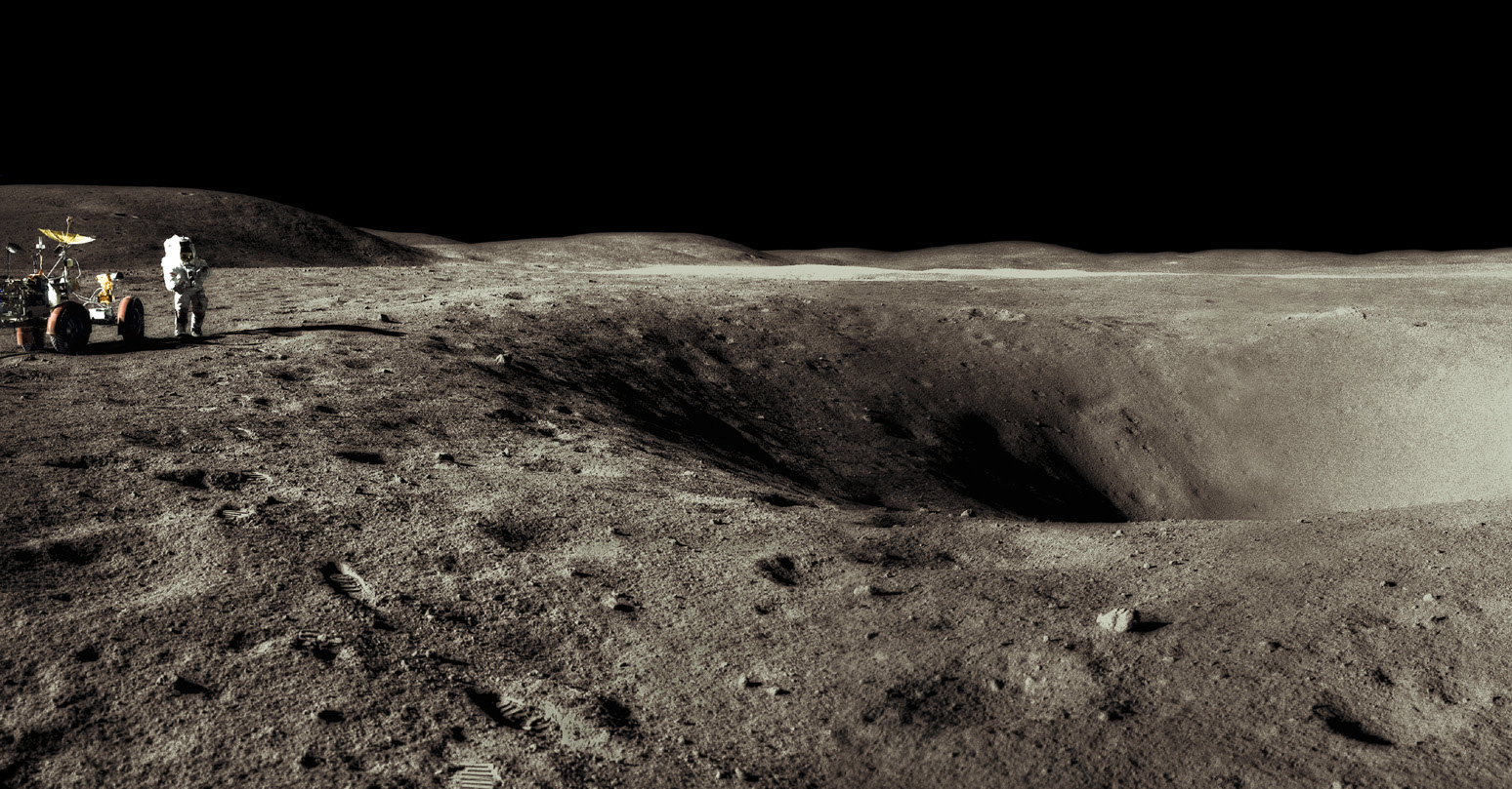
- Apollo 16 Surface Journal At the time of the Apollo 16 landing, surface shadows at this site would have pointed essentially due west. Hence this photo appears to have been taken looking south. The hill on the left is probably Stone Mountain, and the light area in the distance beyond Plum is presumably the bright ejecta blanket around South Ray crater. A small part of the lip of Flag crater is visible on the extreme right, as can be seen a larger panorama involving this frame.
- Detail of the Plum panorama above shows the location of the legendary rock called Big Muley (which is the largest one of all the rocks collected during the entire Apollo program!).
- Hi-Res scan of the detail photograph in the Plum panorama (Big Muley's location).
Source: Apollo Lunar Surface Journal (ALSJ), and Project Apollo Archive.
Table of Contents
[#Plum (Apollo 16 site craterlet name) Plum (Apollo 16 site craterlet name)]
[#Plum (Apollo 16 site craterlet name)-Images Images]
[#Plum (Apollo 16 site craterlet name)-Maps Maps]
[#Plum (Apollo 16 site craterlet name)-Description Description]
[#Plum (Apollo 16 site craterlet name)-Description: Wikipedia Description: Wikipedia]
[#Plum (Apollo 16 site craterlet name)-Additional Information Additional Information]
[#Plum (Apollo 16 site craterlet name)-Nomenclature Nomenclature]
[#Plum (Apollo 16 site craterlet name)-LPOD Articles LPOD Articles]
[#Plum (Apollo 16 site craterlet name)-Bibliography Bibliography]
Images
LPOD Photo Gallery Lunar Orbiter Images Apollo Images
- Mike Constantine's assembled panorama shows Plum crater (central) and Flag crater (left, adjacent to Plum). Stone Mountain is at right. Compared to the image displayed above, the photos for this 360° view appear to have been taken from the opposite (south) rim of Plum crater , hence the left-right reversal in its position relative to Flag. The two astronauts in this panorama are both Charles Duke (photographed at different times).
- Don Davis' colored version of the Plum pan above (from black-and-white Hasselblad photographs).
Maps
(LAC zone 78D2) LAC map Geologic map LM map LTO map
Description
Description: Wikipedia
Big Muley (one of the most famous lunar rocks, this one collected near Plum crater).
Plum (not exactly the above mentioned crater...).
Additional Information
- According to the Apollo 16 Lunar Surface Journal, Plum is about 40 m in diameter. - JimMosher JimMosher
- The astronauts search for Plum crater is described in some detail on pp. 191ff of David M. Harland's Exploring the Moon: The Apollo Expeditions (Springer, 1999).
Nomenclature
Astronaut-named feature, Apollo 16 site.
- IAU Transactions XVIB says that Plum is a "large crater with Flag on the rim," and the IAU Planetary Gazetteer gives Topophotomap 78D2/S1 as the primary map reference for this Landing Site Name. The name Plum is not listed on that map, nor on the Apollo 16 Site Traverses chart. Moreover, the IAU description conflicts with the Apollo 16 planning materials which identified Plum as a very small crater on the southeast rim of Flag, rather than the other way around. See for example the April 1972 Lunar Surface Procedures traverse map and the labeled aerial photo from the Apollo 16 Surface Journal website. - JimMosher JimMosher
LPOD Articles
Bibliography
David M. Harland: EXPLORING THE MOON, the Apollo expeditions.
  Eric M. Jones: APOLLO LUNAR SURFACE JOURNAL (ALSJ).
This page has been edited 1 times. The last modification was made by - tychocrater tychocrater on Jun 13, 2009 3:24 pm - afx3u2