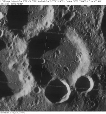
Marinus
Contents
Marinus
|
Lat: 39.4°S, Long: 76.5°E, Diam: 58 km, Depth: 2.96 km, [/R%C3%BCkl%2069 Rükl 69] |
Table of Contents
[#Marinus Marinus]
[#Marinus-Images Images]
[#Marinus-Maps Maps]
[#Marinus-Description Description]
[#Marinus-Description: Elger Description: Elger]
[#Marinus-Description: Wikipedia Description: Wikipedia]
[#Marinus-Additional Information Additional Information]
[#Marinus-Nomenclature Nomenclature]
[#Marinus-LPOD Articles LPOD Articles]
[#Marinus-Bibliography Bibliography]

LO-IV-178H
Images
LPOD Photo Gallery Lunar Orbiter Images Apollo Images
WARNING: the LPI's orbital Apollo photograph AS14-75-10304 doesn't show Marinus because the eastern equatorial zone of Mare Smythii and Mare Marginis was captured, not the southern region of Mare Australe!
Detection of error: Danny Caes
Maps
([/LAC%20zone LAC zone] 115B3) USGS Digital Atlas PDF
Description
Description: Elger
([/IAU%20Directions IAU Directions]) MARINUS.--A ring-plain on the N.W. side of the [/Mare%20Australe Mare Australe], between [/Furnerius Furnerius] and the limb.
Description: Wikipedia
Additional Information
Depth data from [/Kurt%20Fisher%20crater%20depths Kurt Fisher database]
- Westfall, 2000: 2.96 km
- Satellite crater Marinus A is on the [/ALPO%20list%20of%20banded%20craters ALPO list of banded craters]
Nomenclature
- Marinus of Tyre (ca. 70 - 130 A.D.) was a Phoenician (Greek) geographer, cartographer and mathematician, who founded mathematical geography. His chief merits were that he assigned to each place its proper latitude and longtitude. He introduced improvements to the construction of maps and developed a system of nautical charts. His maps were the first in the Roman Empire to show China. The equirectangular projection was invented by Marinus of Tyre and still used in map creation today.
  - Madler's name Marinus was also used by Hevelius, as Lacus Marinus (the region west of Archimedes).- DannyCaes DannyCaes Oct 24, 2013
LPOD Articles
Bibliography
This page has been edited 1 times. The last modification was made by - tychocrater tychocrater on Jun 13, 2009 3:24 pm - afx3u2