Difference between revisions of "Isabel"
(Created page with "<div id="content_view" class="wiki" style="display: block"> =Isabel= {| class="wiki_table" | colspan="2" | Lat: 28.166°N, Long: 34.085°W, Diam: 1.4 km, Depth: 0.177 km,...") |
|||
| (2 intermediate revisions by the same user not shown) | |||
| Line 3: | Line 3: | ||
{| class="wiki_table" | {| class="wiki_table" | ||
| colspan="2" | | | colspan="2" | | ||
| − | Lat: 28.166°N, Long: 34.085°W, Diam: 1.4 km, Depth: 0.177 km, [http://the-moon. | + | Lat: 28.166°N, Long: 34.085°W, Diam: 1.4 km, Depth: 0.177 km, [http://the-moon.us/wiki/R%C3%BCkl%2019 Rükl: 19]<br /> |
|} | |} | ||
<div id="toc"> | <div id="toc"> | ||
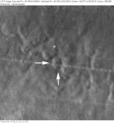
| − | + | [http://www.lpod.org/coppermine/albums/userpics/Isabel_LO-IV-156H_LTVT.JPG [[Image:Normal_Isabel_LO-IV-156H_LTVT.JPG|external image normal_Isabel_LO-IV-156H_LTVT.JPG]]][http://the-moon.us/wiki/file/detail/isabel.jpg [[Image:Isabel-small.jpg|isabel-small.jpg]]]<br /> '''Left:''' ''[http://lpod.org/coppermine/displayimage.php?pos=-2055 LO-IV-156H]'' Isabel is the crater indicated by the white arrows.<br /> '''Right:''' Combined [http://wms.lroc.asu.edu/ LROC NAC] images - [http://wms.lroc.asu.edu/lroc/view_lroc/LRO-L-LROC-2-EDR-V1.0/M104740941LE M104740941LE] and [http://wms.lroc.asu.edu/lroc/view_lroc/LRO-L-LROC-2-EDR-V1.0/M104740941RE M104740941RE].<br /> <br /> | |
| − | |||
==Images== | ==Images== | ||
| − | [http://www.lpod.org/coppermine/thumbnails.php?album=search&type=full&search=Isabel LPOD Photo Gallery] [http://www.lpi.usra.edu/resources/lunar_orbiter/bin/srch_nam.shtml?Isabel%7C0 Lunar Orbiter Images] [http://www.lpi.usra.edu/resources/apollo/search/feature/?feature=Isabel Apollo Images]<br /> Because '''Isabel''''s location is immediately north-northeast of '''Diophantus''', all orbital Apollo photos of '''Isabel''' should be online in the LPI's list of [http://www.lpi.usra.edu/resources/apollo/search/feature/?feature=Diophantus Diophantus]. However, this list needs further exploration and investigation because not all of the mentioned frames show the '''Diophantus-Isabel''' area! <span class="membersnap">- | + | [http://www.lpod.org/coppermine/thumbnails.php?album=search&type=full&search=Isabel LPOD Photo Gallery] [http://www.lpi.usra.edu/resources/lunar_orbiter/bin/srch_nam.shtml?Isabel%7C0 Lunar Orbiter Images] [http://www.lpi.usra.edu/resources/apollo/search/feature/?feature=Isabel Apollo Images]<br /> Because '''Isabel''''s location is immediately north-northeast of '''Diophantus''', all orbital Apollo photos of '''Isabel''' should be online in the LPI's list of [http://www.lpi.usra.edu/resources/apollo/search/feature/?feature=Diophantus Diophantus]. However, this list needs further exploration and investigation because not all of the mentioned frames show the '''Diophantus-Isabel''' area! <span class="membersnap">- DannyCaes <small>Jun 30, 2012</small></span><br /> <br /> |
==Maps== | ==Maps== | ||
| − | ''([http://the-moon. | + | ''([http://the-moon.us/wiki/LAC%20zone LAC zone] 39B2)'' [http://www.lpi.usra.edu/resources/mapcatalog/LAC/lac39/ LAC map] [http://www.lpi.usra.edu/resources/mapcatalog/usgs/I465/ Geologic map] [http://www.lpi.usra.edu/resources/mapcatalog/LM/lm39/ LM map] [http://www.lpi.usra.edu/resources/mapcatalog/LTO/lto39b2_1/ LTO map] [http://www.lpi.usra.edu/resources/mapcatalog/topophoto/39B2S1/ Topophotomap]<br /> <br /> |
==Description== | ==Description== | ||
| − | Isabel is a somewhat irregularly shaped crater that has received a name only by virtue of its having been labeled on a [http://the-moon. | + | Isabel is a somewhat irregularly shaped crater that has received a name only by virtue of its having been labeled on a [http://the-moon.us/wiki/Topophotomap Topophotomap], and the subsequent adoption of those names by the [http://the-moon.us/wiki/IAU IAU].<br /> <span class="membersnap">- Jim Mosher</span><br /> <br /> |
==Description: Wikipedia== | ==Description: Wikipedia== | ||
[http://en.wikipedia.org/wiki/Isabel_(crater) Isabel]<br /> <br /> | [http://en.wikipedia.org/wiki/Isabel_(crater) Isabel]<br /> <br /> | ||
==Additional Information== | ==Additional Information== | ||
| − | * According to [http://the-moon. | + | * According to [http://the-moon.us/wiki/NASA%20RP-1097 NASA RP-1097], "Isabel" is a [http://the-moon.us/wiki/Minor%20Feature Minor Feature] whose name was originally intended only for use in connection with [http://www.lpi.usra.edu/resources/mapcatalog/topophoto/39B2S1/ Topophotomap 39B2/S1](on which it is plotted). |
<br /> | <br /> | ||
| − | * The position and dimensions given in the title line are from that topophotomap as read by [http://the-moon. | + | * The position and dimensions given in the title line are from that topophotomap as read by [http://the-moon.us/wiki/LTVT LTVT]. The depth was read from the highest point on the rim to the lowest point on the floor. On the topophotomap, that deepest point is indicated as falling at 28.162N/34.089W. The official IAU values listed in the ''Planetary Gazetteer'' database are: Lat: 28.2°N, Long: 34.1°W, Diam: 1 km. |
<br /> | <br /> | ||
| − | * The other [http://the-moon. | + | * The other [http://the-moon.us/wiki/Minor%20Feature Minor Features] labeled on [http://www.lpi.usra.edu/resources/mapcatalog/topophoto/39B2S1/ Topophotomap 39B2/S1] are [http://the-moon.us/wiki/Samir Samir], [http://the-moon.us/wiki/Louise Louise] and [http://the-moon.us/wiki/Walter Walter].<br /> <span class="membersnap">- Jim Mosher</span> |
<br /> | <br /> | ||
==Nomenclature== | ==Nomenclature== | ||
| Line 32: | Line 31: | ||
<br /> <br /> | <br /> <br /> | ||
---- | ---- | ||
| − | + | </div> | |
Latest revision as of 02:54, 16 April 2018
Contents
Isabel
|
Lat: 28.166°N, Long: 34.085°W, Diam: 1.4 km, Depth: 0.177 km, Rükl: 19 |

Left: LO-IV-156H Isabel is the crater indicated by the white arrows.
Right: Combined LROC NAC images - M104740941LE and M104740941RE.
Images
LPOD Photo Gallery Lunar Orbiter Images Apollo Images
Because Isabel's location is immediately north-northeast of Diophantus, all orbital Apollo photos of Isabel should be online in the LPI's list of Diophantus. However, this list needs further exploration and investigation because not all of the mentioned frames show the Diophantus-Isabel area! - DannyCaes Jun 30, 2012
Maps
(LAC zone 39B2) LAC map Geologic map LM map LTO map Topophotomap
Description
Isabel is a somewhat irregularly shaped crater that has received a name only by virtue of its having been labeled on a Topophotomap, and the subsequent adoption of those names by the IAU.
 - Jim Mosher
Description: Wikipedia
Additional Information
- According to NASA RP-1097, "Isabel" is a Minor Feature whose name was originally intended only for use in connection with Topophotomap 39B2/S1(on which it is plotted).
- The position and dimensions given in the title line are from that topophotomap as read by LTVT. The depth was read from the highest point on the rim to the lowest point on the floor. On the topophotomap, that deepest point is indicated as falling at 28.162N/34.089W. The official IAU values listed in the Planetary Gazetteer database are: Lat: 28.2°N, Long: 34.1°W, Diam: 1 km.
- The other Minor Features labeled on Topophotomap 39B2/S1 are Samir, Louise and Walter.
- Jim Mosher
Nomenclature
Spanish female name.
LPOD Articles
Bibliography
