Difference between revisions of "Foster"
(Created page with "<div id="content_view" class="wiki" style="display: block"> =Foster= {| class="wiki_table" | Lat: 23.7°N, Long: 141.5°W, Diam: 33 km, Depth: km, Rükl: ''(farside)''<br /...") |
|||
| Line 9: | Line 9: | ||
[[Image:foster-color.jpg|foster-color.jpg]]<br /> | [[Image:foster-color.jpg|foster-color.jpg]]<br /> | ||
|} | |} | ||
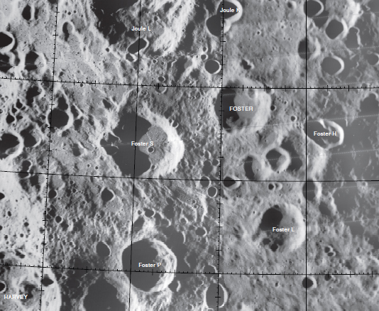
| − | '''Left:''' [http://www.mapaplanet.org/explorer-bin/explorer.cgi?map=Moon&layers=moon_clementine_base_v2&west=539&south=702&east=903&north=403¢er=236.375¢er_lat=0&defaultcenter=on&grid=none&stretch=auto&resamp_method=nearest_neighbor&projection=SIMP&r=1&g=1&b=1&advoption=NO&info=NO&resolution=25.0664893617021&lines=1131&samples=2278&scale=1.20971&imageTopX=-1377262.4375224113&imageTopY=1350648.6706137657&box=yes&x=896&y=695 Clementine] view. '''Right:''' [http://planetarynames.wr.usgs.gov/images/Lunar/lac_52.pdf Color-coded topography LAC 52] image from [ | + | '''Left:''' [http://www.mapaplanet.org/explorer-bin/explorer.cgi?map=Moon&layers=moon_clementine_base_v2&west=539&south=702&east=903&north=403¢er=236.375¢er_lat=0&defaultcenter=on&grid=none&stretch=auto&resamp_method=nearest_neighbor&projection=SIMP&r=1&g=1&b=1&advoption=NO&info=NO&resolution=25.0664893617021&lines=1131&samples=2278&scale=1.20971&imageTopX=-1377262.4375224113&imageTopY=1350648.6706137657&box=yes&x=896&y=695 Clementine] view. '''Right:''' [http://planetarynames.wr.usgs.gov/images/Lunar/lac_52.pdf Color-coded topography LAC 52] image from [[USGS%20Digital%20Atlas|USGS Digital Atlas]].<br /> <div id="toc"> |
=Table of Contents= | =Table of Contents= | ||
<div style="margin-left: 1em">[#Foster Foster]</div><div style="margin-left: 2em">[#Foster-Images Images]</div><div style="margin-left: 2em">[#Foster-Maps Maps]</div><div style="margin-left: 2em">[#Foster-Description Description]</div><div style="margin-left: 2em">[#Foster-Description: Wikipedia Description: Wikipedia]</div><div style="margin-left: 2em">[#Foster-Additional Information Additional Information]</div><div style="margin-left: 2em">[#Foster-Nomenclature Nomenclature]</div><div style="margin-left: 2em">[#Foster-Lettered Craters Lettered Craters]</div><div style="margin-left: 2em">[#Foster-LPOD Articles LPOD Articles]</div><div style="margin-left: 2em">[#Foster-Bibliography Bibliography]</div></div><br /> | <div style="margin-left: 1em">[#Foster Foster]</div><div style="margin-left: 2em">[#Foster-Images Images]</div><div style="margin-left: 2em">[#Foster-Maps Maps]</div><div style="margin-left: 2em">[#Foster-Description Description]</div><div style="margin-left: 2em">[#Foster-Description: Wikipedia Description: Wikipedia]</div><div style="margin-left: 2em">[#Foster-Additional Information Additional Information]</div><div style="margin-left: 2em">[#Foster-Nomenclature Nomenclature]</div><div style="margin-left: 2em">[#Foster-Lettered Craters Lettered Craters]</div><div style="margin-left: 2em">[#Foster-LPOD Articles LPOD Articles]</div><div style="margin-left: 2em">[#Foster-Bibliography Bibliography]</div></div><br /> | ||
| Line 15: | Line 15: | ||
[http://www.lpod.org/coppermine/thumbnails.php?album=search&type=full&search=Foster LPOD Photo Gallery] [http://www.lpi.usra.edu/resources/lunar_orbiter/bin/srch_nam.shtml?Foster%7C0 Lunar Orbiter Images] [http://www.lpi.usra.edu/resources/apollo/search/feature/?feature=Foster Apollo Images]<br /> <br /> | [http://www.lpod.org/coppermine/thumbnails.php?album=search&type=full&search=Foster LPOD Photo Gallery] [http://www.lpi.usra.edu/resources/lunar_orbiter/bin/srch_nam.shtml?Foster%7C0 Lunar Orbiter Images] [http://www.lpi.usra.edu/resources/apollo/search/feature/?feature=Foster Apollo Images]<br /> <br /> | ||
==Maps== | ==Maps== | ||
| − | ''([ | + | ''([[LAC%20zone|LAC zone]] 52D2)'' [http://planetarynames.wr.usgs.gov/images/Lunar/lac_52.pdf USGS Digital Atlas PDF]<br /> <br /> |
==Description== | ==Description== | ||
<br /> | <br /> | ||
Revision as of 15:48, 15 April 2018
Contents
Foster
| Lat: 23.7°N, Long: 141.5°W, Diam: 33 km, Depth: km, Rükl: (farside) | |
Table of Contents
[#Foster Foster]
[#Foster-Images Images]
[#Foster-Maps Maps]
[#Foster-Description Description]
[#Foster-Description: Wikipedia Description: Wikipedia]
[#Foster-Additional Information Additional Information]
[#Foster-Nomenclature Nomenclature]
[#Foster-Lettered Craters Lettered Craters]
[#Foster-LPOD Articles LPOD Articles]
[#Foster-Bibliography Bibliography]
Images
LPOD Photo Gallery Lunar Orbiter Images Apollo Images
Maps
(LAC zone 52D2) USGS Digital Atlas PDF
Description
Description: Wikipedia
Additional Information
Nomenclature
John Stuart; Canadian physicist (1890-1964).
Lettered Craters

Excerpt from the //USGS Digital Atlas of the Moon.
LPOD Articles
Bibliography
This page has been edited 1 times. The last modification was made by - tychocrater tychocrater on Jun 13, 2009 3:24 pm - afx3u2

