DMA
Contents
Defense Mapping Agency (DMA)
(glossary entry)Table of Contents
[#Defense Mapping Agency (DMA) Defense Mapping Agency (DMA)]
[#Defense Mapping Agency (DMA)-Description Description]
[#Defense Mapping Agency (DMA)-Additional Information Additional Information]
[#Defense Mapping Agency (DMA)-LPOD Articles LPOD Articles]
[#Defense Mapping Agency (DMA)-Bibliography Bibliography]
Description
The DMA, which is itself now part of the U.S. National Geospatial Intelligence Agency, absorbed in 1972 two organizations responsible for producing many of the most significant [/lunar%20maps lunar maps] made in connection with the [/Apollo%20program Apollo program] and its predecessors:
- The Aeronautical Chart Information Center (or ACIC) was a United States Air Force organization headquartered in St. Louis, MO. After incorporation into the DMA it became officially known as the "DMA Aerospace Center" (DMAAC)
- The U .S. Army Map Service (or AMS), headquartered in Bethesda, MD became the U .S. Army Topographic Command (TOPOCOM) in September 1968. After incorporation into the DMA its official name became the "Defense Mapping Agency Topographic Center" (DMATC).
Additional Information
- The history of the maps produced by these agencies through about 1972 is well told and documented in [/Kopal%20and%20Carder%2C%201974 Kopal and Carder, 1974].
- One of the more celebrated early products of the ACIC was the USAF Lunar Reference Mosaic, a composite photographic image of the Moon as seen from Earth at near constant illumination.
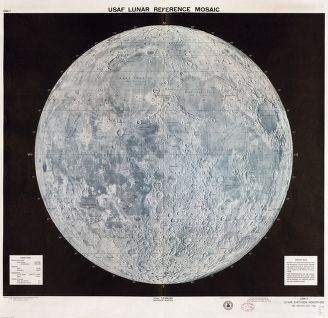 It is available in the Library of Congress' American Memory Map Collection. This was originally compiled in February 1960 and issued in 1:10,0000,0000 (LEM-lA, 14-inch diameter) and 1:5,000,0000 ((LEM-I) formats. It was redone in 1962, including a new two page set at 1:2,500,000 (4.5 foot diameter) known as the USAF Lunar Wall Mosaic (LEM-IB) with all then-current feature names imprinted on it.
- Prior to the first US spacecraft reaching the Moon, the ACIC is also credited with conceiving and carrying to completion the highly influential [/LAC LAC] series of navigational charts (which served as basemaps for early geologic mapping), as well as the more detailed [/AIC AIC] series.
- Other noteworthy ACIC products include airbrush maps of the Ranger impact areas, the first American maps including the [/LMP farside] and a lunar globe.
- Early efforts by the AMS concentrated on trying to construct, with less success, global [/LTM topographic maps].
- Both agencies participated in mapping data from [/Lunar%20Orbiter Lunar Orbiter] and [/Apollo%20program Apollo], where artistic renderings gave way to direct rectification and reproduction of the photographic data on scaled and labeled maps.

LPOD Articles
Bibliography
- Carder, R. W. 1962. Lunar Mapping on a Scale of 1:1000000. IAU Symposium 14, pp. 117-129.
- Carder, R. W. and Scott, S. P. 1966. Lunar Charting for Project Apollo. Navigation, Vol. 13, No. 1 (Spring issue), pp. 49-58.
- Eriksen, J. G. 1965. "Lunar charting". Air Univ. Rev., 16, p. 76.
- Kopal, Zdenek; Carder, Robert W. 1974. [/Kopal%20and%20Carder%2C%201974 Mapping of the moon. Past and present]. Astrophysics and Space Science Library, Dordrecht: Reidel.
- Schimerman, Lawrence A., ed., 1973, [/Lunar%20Cartographic%20Dossier Lunar Cartographic Dossier], Volume I, NASA and the Defense Mapping Agency, St. Louis, Missouri. With changes and additions to 1977 July. (approx. 359 pp).
- St. Clair, J. H.; Carder, R. W.; Schimerman, L. A. 1979. United States lunar mapping - A basis for and result of project Apollo. Moon and the Planets, vol. 20, Apr. 1979, p. 127-148.
- Weir, Gary E. 2009. Our Heritage: Lunar Cartography Informed Early Space Program. NGA Pathfinder Nov-Dec.
This page has been edited 1 times. The last modification was made by - tychocrater tychocrater on Jun 13, 2009 3:24 pm - mgx1