Difference between revisions of "Cx35"
(Created page with "<div id="content_view" class="wiki" style="display: block"> =Constellation Program Regions of Interest for Human Exploration= <div id="toc"> =Table of Contents= <div style...") |
|||
| Line 11: | Line 11: | ||
<br /> | <br /> | ||
==Tier 1 Nearside Targets== | ==Tier 1 Nearside Targets== | ||
| − | [http://the-moon. | + | [http://the-moon.us/wiki/file/detail/CxP_Tier1_ROI_LocatorMap.jpg [[Image:CxP_Tier1_ROI_LocatorMap.jpg|external image CxP_Tier1_ROI_LocatorMap.jpg?size=64]]]''<-- click to see locations of Tier 1 RoI's (the background image is the Kaguya [http://ltvt.wikispaces.com/Additional%20Textures grayscale DEM])''<br /> |
{| class="wiki_table" | {| class="wiki_table" | ||
| '''Feature Name'''<br /> | | '''Feature Name'''<br /> | ||
| Line 114: | Line 114: | ||
<br /> | <br /> | ||
==Tier 2 Nearside Targets== | ==Tier 2 Nearside Targets== | ||
| − | [http://the-moon. | + | [http://the-moon.us/wiki/file/detail/CxP_Tier2_ROI_LocatorMap.jpg [[Image:CxP_Tier2_ROI_LocatorMap.jpg|external image CxP_Tier2_ROI_LocatorMap.jpg?size=64]]]''<-- click to see locations of Tier 1 RoI's (the background image is the Kaguya [http://ltvt.wikispaces.com/Additional%20Textures grayscale DEM])''<br /> |
{| class="wiki_table" | {| class="wiki_table" | ||
| '''Feature Name'''<br /> | | '''Feature Name'''<br /> | ||
Revision as of 20:12, 11 April 2018
Contents
Constellation Program Regions of Interest for Human Exploration
Table of Contents
Description
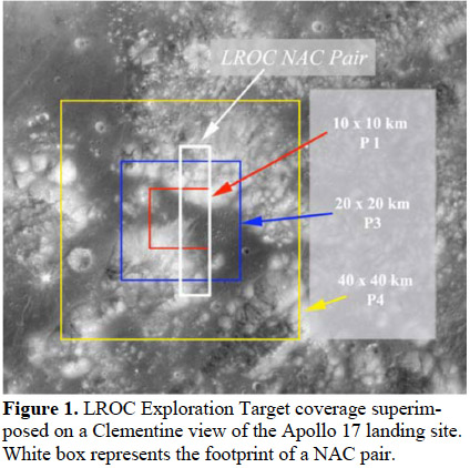
NASA is interested in these Regions of Interest (RoI) as possible exploration sites when we return to the Moon as part of the [/Constellation%20Program Constellation Program] (CxP). I propose that for each of the sites visible from Earth that a data collection page be established, much as this wiki does for each named feature, but in more detail. For example, NASA is imaging a 40 x 40 km square to provide context for the details seen in 20 x 20 km and 10 x 10 km nested areas. Amateurs can provide excellent wider scale context by collecting images of, say 250 x 250 km and 100 x 100 km squares under various lighting conditions. Amateurs can find and link to fundamental professional publications (and LPODs!) for each of these areas. Many more types of information can be added, and wikis provide the flexibility to do so. More will come here soon, and then over the next years.

  Note that each of these targets is just a small area within a larger feature - we typically cannot just use the existing Moon Wiki page for these RoI's. Note also that a new manned landing on the Moon by NASA is still a long way off and much new knowledge about the Moon will be gained by then. Although the present list of intensively studied RoI's is "representative" of the areas where manned exploration might take place, the eventual landings could be elsewhere.

  Thanks for your visits and contributions!
 - tychocrater tychocrater Jan 8, 2010

Illustration of coverage of RoI squares and nominal NAC dual images footprint.
From B. L. Jolliff et al. (2009)
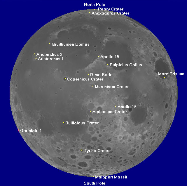
Tier 1 Nearside Targets
 <-- click to see locations of Tier 1 RoI's (the background image is the Kaguya grayscale DEM)
| Feature Name |
Long |
Lat |
|
[/RoI%20-%20Alphonsus%20Crater Alphonsus Crater] |
-2.16 |
-12.56 |
|
[/RoI%20-%20Anaxagoras%20Crater Anaxagoras Crater] |
-9.30 |
73.48 |
|
[/RoI%20-%20Apollo%2015 Apollo 15] |
3.66 |
26.08 |
|
[/RoI%20-%20Apollo%2016 Apollo 16] |
15.47 |
-9.00 |
|
[/RoI%20-%20Aristarchus%201 Aristarchus 1] |
-48.95 |
24.56 |
|
[/RoI%20-%20Aristarchus%202 Aristarchus 2] |
-52.40 |
27.70 |
|
[/RoI%20-%20Bullialdus%20Crater Bullialdus Crater] |
-22.50 |
-20.70 |
|
[/RoI%20-%20Copernicus%20Crater Copernicus Crater] |
-20.01 |
9.85 |
|
[/RoI%20-%20Gruithuisen%20Domes Gruithuisen Domes] |
-40.14 |
36.03 |
|
[/RoI%20-%20Malapert%20Massif Malapert Massif] |
-2.93 |
-85.99 |
|
[/RoI%20-%20Mare%20Crisium Mare Crisium] |
58.84 |
10.68 |
|
[/RoI%20-%20Murchison%20Crater Murchison Crater] |
-0.42 |
4.74 |
| [/RoI%20-%20North%20Pole North Pole] |
76.19 |
89.60 |
| [/RoI%20-%20Orientale%201 Orientale 1] |
-95.38 |
-26.20 |
| [/RoI%20-%20Peary%20Crater Peary Crater] |
30.00 |
88.50 |
|
[/RoI%20-%20Rima%20Bode Rima Bode] |
-3.80 |
12.90 |
| [/RoI%20-%20South%20Pole South Pole] |
-130.00 |
-89.30 |
|
[/RoI%20-%20Sulpicius%20Gallus Sulpicius Gallus] |
10.37 |
19.87 |
|
[/RoI%20-%20Tycho%20Crater Tycho Crater] |
-11.20 |
-42.99 |
Italics = in libration zone, visible from Earth only with favorable [/librations librations]
- (Orientale 1 is slightly beyond the limb at mean libration)
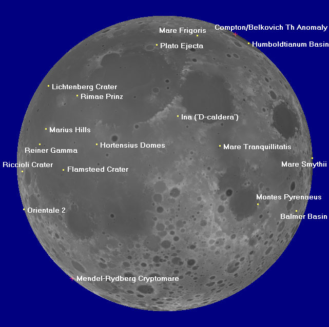
Tier 2 Nearside Targets
 <-- click to see locations of Tier 1 RoI's (the background image is the Kaguya grayscale DEM)
| Feature Name |
Long |
Lat |
|
[/RoI%20-%20Balmer%20Basin Balmer Basin] |
69.82 |
-18.69 |
| [/RoI%20-%20Compton-Belkovich%20Th%20Anomaly Compton/Belkovich Th Anomaly] |
99.45 |
61.11 |
|
[/RoI%20-%20Flamsteed%20Crater Flamsteed Crater] |
-43.22 |
-2.45 |
|
[/RoI%20-%20Hortensius%20Domes Hortensius Domes] |
-27.67 |
7.48 |
|
[/RoI%20-%20Humboldtianum%20Basin Humboldtianum Basin] |
77.14 |
54.54 |
|
[/RoI%20-%20Ina%20%28%27D-Caldera%27%29 Ina ('D-caldera')] |
5.29 |
18.65 |
|
[/RoI%20-%20Lichtenberg%20Crater Lichtenberg Crater] |
-67.23 |
31.65 |
|
[/RoI%20-%20Mare%20Frigoris Mare Frigoris] |
26.10 |
59.80 |
| [/RoI%20-%20Mare%20Smythii Mare Smythii] |
85.33 |
2.15 |
|
[/RoI%20-%20Mare%20Tranquillitatis Mare Tranquillitatis] |
22.06 |
6.93 |
|
[/RoI%20-%20Marius%20Hills Marius Hills] |
-55.80 |
13.58 |
| [/RoI%20-%20Mendel-Rydberg%20Cryptomare Mendel-Rydberg Cryptomare] |
-93.07 |
-51.14 |
|
[/RoI%20-%20Montes%20Pyrenaeus Montes Pyrenaeus] |
40.81 |
-15.91 |
| [/RoI%20-%20Orientale%202 Orientale 2] |
-87.91 |
-18.04 |
|
[/RoI%20-%20Plato%20Ejecta Plato Ejecta] |
-5.21 |
53.37 |
|
[/RoI%20-%20Reiner%20Gamma Reiner Gamma] |
-58.56 |
7.53 |
|
[/RoI%20-%20Riccioli%20Crater Riccioli Crater] |
-74.28 |
-3.04 |
|
[/RoI%20-%20Rimae%20Prinz Rimae Prinz] |
-41.72 |
27.41 |
Italics = in libration zone, visible from Earth only with favorable [/librations librations]
- (the Compton/Belkovich Th Anomaly and the Mendel-Rydberg Cryptomare are slightly beyond the limb at mean libration)
Farside ROI's
(these Regions of Interest are never visible from Earth)
Tier 1
[/ROI%20-%20Aitken%20Crater ROI - Aitken Crater]
[/ROI%20-%20Apollo%20Basin ROI - Apollo Basin]
[/ROI%20-%20Hertzsprung ROI - Hertzsprung]
[/ROI%20-%20King%20Crater ROI - King Crater]
[/ROI%20-%20South%20Pole-Aitken%20Basin%20Interior ROI - South Pole-Aitken Basin Interior]
[/ROI%20-%20Stratton ROI - Stratton]
Tier 2
[/ROI%20-%20Dante%20Crater ROI - Dante Crater]
[/ROI%20-%20Ingenii ROI - Ingenii]
[/ROI%20-%20Mare%20Moscoviense ROI - Mare Moscoviense]
[/ROI%20-%20Schr%C3%B6dinger ROI - Schrödinger]
[/ROI%20-%20South%20Pole-Aitken%20Rim ROI - South Pole-Aitken Rim]
[/ROI%20-%20Tsiolkovsky%20Crater ROI - Tsiolkovsky Crater]
[/ROI%20-%20Van%20De%20Graaf%20Crater ROI - Van De Graaf Crater]
Additional Information
- According to Lucey et al. (2009: The regions of interest were selected based on three criteria:
1. Science rationale - the 50 sites are of unique scientific interest or are scientifically complex requiring intensive field work with human interaction.
2. Resource potential - as a whole, the 50 sites are representative of the type of natural resources available for development and exploitation.
3. Operational perspective - as a whole, the 50 sites are representative of the different terrain types that the Altair lunar lander and the various lunar surface systems may encounter. - The Constellation Regions of Interest are available as dot files for plotting with the LTVT software (see sample LTVT-produced nearside finder images, above), as is the much larger list of targets of scientific interest being explored with the Lunar Reconnaissance Orbiter Cameras.
LPOD Articles
Bibliography
- Lucey, P. G. et al. (2009) LEAG Review of Constellation Program Regions of Interest for Human Exploration of the Moon. Lunar Reconnaissance Orbiter Science Targeting Meeting, held June 9-11, 2009 in Tempe, Arizona. LPI Contribution No. 1483, p.73-74
- Jolliff, B. L. et al. (2009) Targeting the Lunar Reconnaissance Orbiter Narrow Angle Cameras: Target sources and selection strategy. 40th Lunar and Planetary Science Conference, (Lunar and Planetary Science XL), held March 23-27, 2009 in The Woodlands, Texas, id.2343
- NASA's PDF list of Tier 1 sites
- NASA's PDF list of Tier 2 sites
This page has been edited 1 times. The last modification was made by - tychocrater tychocrater on Jun 13, 2009 3:24 pm