Difference between revisions of "Cassegrain"
(Created page with "<div id="content_view" class="wiki" style="display: block"> =Cassegrain= {| class="wiki_table" | Lat: 52.4°S, Long: 113.5°E, Diam: 55 km, Depth: km, Rükl: ''(farside)''<...") |
|||
| Line 9: | Line 9: | ||
[[Image:Cassegrain.jpg|Cassegrain.jpg]][[Image:cassegrain-color.jpg|cassegrain-color.jpg]]<br /> | [[Image:Cassegrain.jpg|Cassegrain.jpg]][[Image:cassegrain-color.jpg|cassegrain-color.jpg]]<br /> | ||
|} | |} | ||
| − | Left : [http://pdsmaps.wr.usgs.gov/explorer-bin/mapmars4.cgi?WHEREFROM=PZ&VERSION=INTERMEDIATE&DATA_SET_NAME=moon_clementine_bw&PIXEL_TYPE=BIT8&SCALE=pixels/degree&PROJECTION=SINUSOIDAL&RESOLUTION=128&RESAMP_METHOD=NEAREST_NEIGHBOR&BANDS_SELECTED=&FORMAT=JPEG&LONBOX=8&LATBOX=8&GRIDLINE_FREQUENCY=none&STRETCH=NONE&LAT=-50.5&LON=113.5&LINE=1024&SAMP=755 Clementine] . Center : '''''LROC''''' . The high peak inmediately west of '''Cassegrain''' (109° E) can be seen in profile against the limb during very favourable librations.<br /> Right : [http://planetarynames.wr.usgs.gov/images/Lunar/lac_130.pdf Color-coded Lac 130] from [http://the-moon. | + | Left : [http://pdsmaps.wr.usgs.gov/explorer-bin/mapmars4.cgi?WHEREFROM=PZ&VERSION=INTERMEDIATE&DATA_SET_NAME=moon_clementine_bw&PIXEL_TYPE=BIT8&SCALE=pixels/degree&PROJECTION=SINUSOIDAL&RESOLUTION=128&RESAMP_METHOD=NEAREST_NEIGHBOR&BANDS_SELECTED=&FORMAT=JPEG&LONBOX=8&LATBOX=8&GRIDLINE_FREQUENCY=none&STRETCH=NONE&LAT=-50.5&LON=113.5&LINE=1024&SAMP=755 Clementine] . Center : '''''LROC''''' . The high peak inmediately west of '''Cassegrain''' (109° E) can be seen in profile against the limb during very favourable librations.<br /> Right : [http://planetarynames.wr.usgs.gov/images/Lunar/lac_130.pdf Color-coded Lac 130] from [http://the-moon.us/wiki/USGS%20Digital%20Atlas USGS Digital Atlas]<br /> <div id="toc"> |
=Table of Contents= | =Table of Contents= | ||
<div style="margin-left: 1em">[#Cassegrain Cassegrain]</div><div style="margin-left: 2em">[#Cassegrain-Images Images]</div><div style="margin-left: 2em">[#Cassegrain-Maps Maps]</div><div style="margin-left: 2em">[#Cassegrain-Description Description]</div><div style="margin-left: 2em">[#Cassegrain-Description: Wikipedia Description: Wikipedia]</div><div style="margin-left: 2em">[#Cassegrain-Additional Information Additional Information]</div><div style="margin-left: 2em">[#Cassegrain-Nomenclature Nomenclature]</div><div style="margin-left: 2em">[#Cassegrain-LPOD Articles LPOD Articles]</div><div style="margin-left: 2em">[#Cassegrain-Bibliography Bibliography]</div></div> | <div style="margin-left: 1em">[#Cassegrain Cassegrain]</div><div style="margin-left: 2em">[#Cassegrain-Images Images]</div><div style="margin-left: 2em">[#Cassegrain-Maps Maps]</div><div style="margin-left: 2em">[#Cassegrain-Description Description]</div><div style="margin-left: 2em">[#Cassegrain-Description: Wikipedia Description: Wikipedia]</div><div style="margin-left: 2em">[#Cassegrain-Additional Information Additional Information]</div><div style="margin-left: 2em">[#Cassegrain-Nomenclature Nomenclature]</div><div style="margin-left: 2em">[#Cassegrain-LPOD Articles LPOD Articles]</div><div style="margin-left: 2em">[#Cassegrain-Bibliography Bibliography]</div></div> | ||
| Line 15: | Line 15: | ||
[http://www.lpod.org/coppermine/thumbnails.php?album=search&type=full&search=Cassegrain LPOD Photo Gallery] [http://www.lpi.usra.edu/resources/lunar_orbiter/bin/srch_nam.shtml?Cassegrain%7C0 Lunar Orbiter Images] [http://www.lpi.usra.edu/resources/apollo/search/feature/?feature=Cassegrain Apollo Images]<br /> <br /> | [http://www.lpod.org/coppermine/thumbnails.php?album=search&type=full&search=Cassegrain LPOD Photo Gallery] [http://www.lpi.usra.edu/resources/lunar_orbiter/bin/srch_nam.shtml?Cassegrain%7C0 Lunar Orbiter Images] [http://www.lpi.usra.edu/resources/apollo/search/feature/?feature=Cassegrain Apollo Images]<br /> <br /> | ||
==Maps== | ==Maps== | ||
| − | ([http://the-moon. | + | ([http://the-moon.us/wiki/LAC%20zone LAC zone] 130A3) ''[http://planetarynames.wr.usgs.gov/images/Lunar/lac_130.pdf USGS Digital Atlas PDF]''<br /> <br /> |
==Description== | ==Description== | ||
| − | '''Cassegrain''' lies in a lower region of terrain similar in altitude to the [http://the-moon. | + | '''Cassegrain''' lies in a lower region of terrain similar in altitude to the [http://the-moon.us/wiki/Planck Planck Basin] off to its south-east and to the [http://the-moon.us/wiki/Mare%20Australe Australe Basin] off to its north-west -- both of the [http://the-moon.us/wiki/Stratigraphy pre-Nectarian] period (~ 4.6 to 3.92 bn years). The crater's rim and inner terracing has taken on an old appearance, however, remains of its north-western sector seems to have slumped down into the floor producing a series of hummocky hills in the area. In contrast, the remaining floor looks relatively flat with the odd impact coming through, but like '''Cassegrain B''' to its north-east and '''Cassegrain H''' to its south-east, the material is more darker -- possibly due to the deeper underlying lava deposits.<span class="membersnap">- [http://www.wikispaces.com/user/view/JohnMoore2 [[Image:JohnMoore2-lg.jpg|16px|JohnMoore2]]] [http://www.wikispaces.com/user/view/JohnMoore2 JohnMoore2]</span><br /> <br /> |
==Description: Wikipedia== | ==Description: Wikipedia== | ||
[http://en.wikipedia.org/wiki/Cassegrain_(crater) Cassegrain]<br /> <br /> | [http://en.wikipedia.org/wiki/Cassegrain_(crater) Cassegrain]<br /> <br /> | ||
Revision as of 20:11, 11 April 2018
Contents
Cassegrain
| Lat: 52.4°S, Long: 113.5°E, Diam: 55 km, Depth: km, Rükl: (farside) | |
|
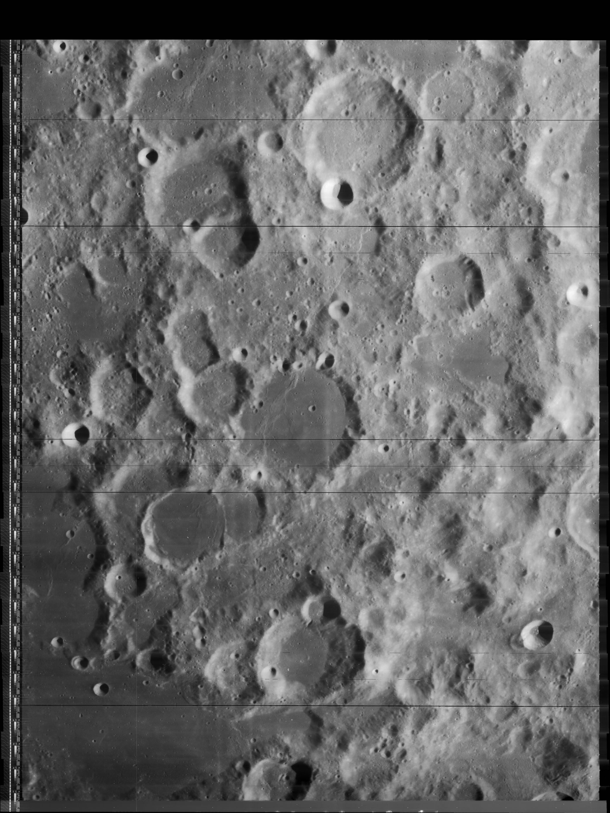
|


Right : Color-coded Lac 130 from USGS Digital Atlas
Table of Contents
Images
LPOD Photo Gallery Lunar Orbiter Images Apollo Images
Maps
(LAC zone 130A3) USGS Digital Atlas PDF
Description
Cassegrain lies in a lower region of terrain similar in altitude to the Planck Basin off to its south-east and to the Australe Basin off to its north-west -- both of the pre-Nectarian period (~ 4.6 to 3.92 bn years). The crater's rim and inner terracing has taken on an old appearance, however, remains of its north-western sector seems to have slumped down into the floor producing a series of hummocky hills in the area. In contrast, the remaining floor looks relatively flat with the odd impact coming through, but like Cassegrain B to its north-east and Cassegrain H to its south-east, the material is more darker -- possibly due to the deeper underlying lava deposits.- JohnMoore2 JohnMoore2
Description: Wikipedia
Additional Information
Nomenclature
- Laurent; French astronomer, doctor (1629-1693).
  - Cassegrain mountain/ Cassegrain peak/ Mons Cassegrain: three unofficial names for the mountainous mass immediately west-northwest of Cassegrain itself. This mountain is observable during very favourable libration of the moon's southeastern limb. The coordinates of Mons Cassegrain are: 51°30' South/ 109°30' East (see page 260 in B.Bussey's and P.Spudis's Clementine Atlas)(LAC 130).
  - Mons Cassegrain is a favourite telescopic object of the dedicated moon observer and LPOD contributor Patricio Leon (Nunki). See LPOD Still on the Limb.
  - Mons Cassegrain was captured near the central parts of the right margins of Lunar Orbiter 4's frames LO4-009-h1 and LO4-011-h1.
  Research: Patricio Leon (Nunki)
LPOD Articles
Bibliography
This page has been edited 1 times. The last modification was made by - tychocrater tychocrater on Jun 13, 2009 3:24 pm - afx2u2//