Difference between revisions of "Baily"
(Created page with "<div id="content_view" class="wiki" style="display: block"> =Baily= {| class="wiki_table" | Lat: 49.7°N, Long: 30.4°E, Diam: 26 km, Depth: 0.52 km, [/R%C3%BCkl%206 Rükl...") |
|||
| Line 3: | Line 3: | ||
{| class="wiki_table" | {| class="wiki_table" | ||
| | | | ||
| − | Lat: 49.7°N, Long: 30.4°E, Diam: 26 km, Depth: 0.52 km, [ | + | Lat: 49.7°N, Long: 30.4°E, Diam: 26 km, Depth: 0.52 km, [[R%C3%BCkl%206|Rükl 6]]<br /> |
|} | |} | ||
<div id="toc"> | <div id="toc"> | ||
| Line 10: | Line 10: | ||
==Images== | ==Images== | ||
[http://www.lpod.org/coppermine/thumbnails.php?album=search&type=full&search=Baily LPOD Photo Gallery] [http://www.lpi.usra.edu/resources/lunar_orbiter/bin/srch_nam.shtml?Baily%7C0 Lunar Orbiter Images]<br /> | [http://www.lpod.org/coppermine/thumbnails.php?album=search&type=full&search=Baily LPOD Photo Gallery] [http://www.lpi.usra.edu/resources/lunar_orbiter/bin/srch_nam.shtml?Baily%7C0 Lunar Orbiter Images]<br /> | ||
| − | * The system of unnamed [ | + | * The system of unnamed [[rima|rimae]] and the elongated depression south of '''Baily B''' were captured on Lunar Orbiter 4's photographs [http://www.lpi.usra.edu/resources/lunarorbiter/images/preview/4086_h3.jpg LOIV-86-h3] and [http://www.lpi.usra.edu/resources/lunarorbiter/images/preview/4091_h3.jpg 91-h3]. They are interesting telescopic targets for observers of the '''Baily''' region. Research: Danny Caes |
<br /> | <br /> | ||
==Maps== | ==Maps== | ||
| − | ''([ | + | ''([[LAC%20zone|LAC zone]] 13C4)'' [http://www.lpi.usra.edu/resources/mapcatalog/LAC/lac13/ LAC map] [http://www.lpi.usra.edu/resources/mapcatalog/usgs/I725/ Geologic map]<br /> <br /> |
==Description== | ==Description== | ||
<br /> | <br /> | ||
==Description: Elger== | ==Description: Elger== | ||
| − | ''([ | + | ''([[IAU%20Directions|IAU Directions]])'' BAILY.--A small ring-plain, N. of [[B%C3%BCrg|Burg]], flanked by mountains, with a large bright crater on the E. The group of mountains standing about midway between it and [[B%C3%BCrg|Burg]] are very noteworthy.<br /> <br /> |
==Description: Wikipedia== | ==Description: Wikipedia== | ||
[http://en.wikipedia.org/wiki/Baily_(crater) Baily]<br /> <br /> | [http://en.wikipedia.org/wiki/Baily_(crater) Baily]<br /> <br /> | ||
==Additional Information== | ==Additional Information== | ||
| − | * Depth data from [ | + | * Depth data from [[Kurt%20Fisher%20crater%20depths|Kurt Fisher database]] |
** Pike, 1976: 0.52 km | ** Pike, 1976: 0.52 km | ||
** Westfall, 2000: 0.52 km | ** Westfall, 2000: 0.52 km | ||
| − | * Satellite crater Baily K is on the [ | + | * Satellite crater Baily K is on the [[ALPO%20list%20of%20bright%20ray%20craters|ALPO list of bright ray craters]]. |
<br /> | <br /> | ||
==Nomenclature== | ==Nomenclature== | ||
Revision as of 15:40, 15 April 2018
Contents
Baily
|
Lat: 49.7°N, Long: 30.4°E, Diam: 26 km, Depth: 0.52 km, Rükl 6 |
Table of Contents
[#Baily Baily]
[#Baily-Images Images]
[#Baily-Maps Maps]
[#Baily-Description Description]
[#Baily-Description: Elger Description: Elger]
[#Baily-Description: Wikipedia Description: Wikipedia]
[#Baily-Additional Information Additional Information]
[#Baily-Nomenclature Nomenclature]
[#Baily-LPOD Articles LPOD Articles]
[#Baily-Bibliography Bibliography]
[#Baily-Francis Baily and his beads in the Sourcebook Project (William R. Corliss) Francis Baily and his beads in the Sourcebook Project (William R. Corliss)]

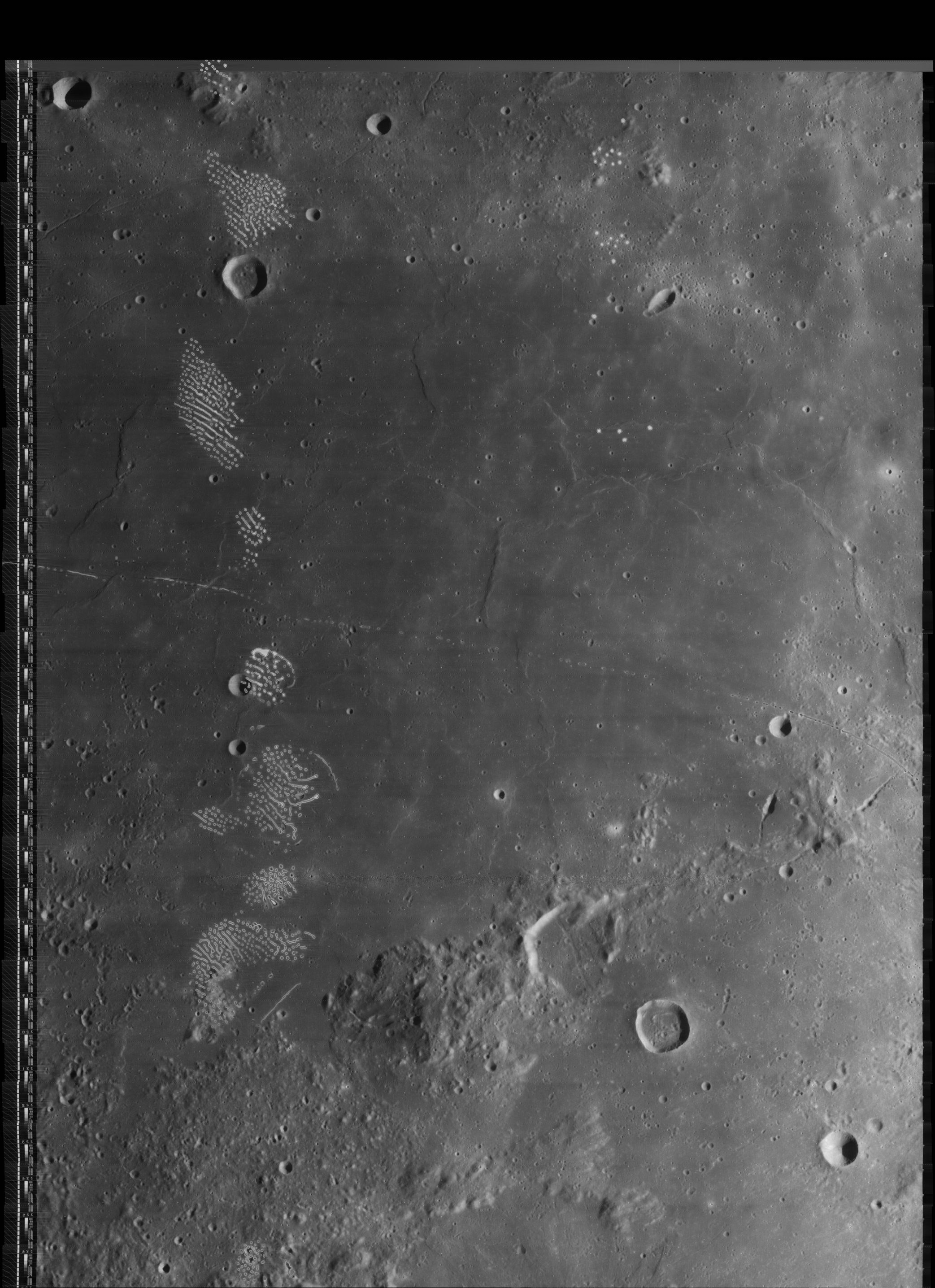
LO4-091-h3
Images
LPOD Photo Gallery Lunar Orbiter Images
- The system of unnamed rimae and the elongated depression south of Baily B were captured on Lunar Orbiter 4's photographs LOIV-86-h3 and 91-h3. They are interesting telescopic targets for observers of the Baily region. Research: Danny Caes
Maps
(LAC zone 13C4) LAC map Geologic map
Description
Description: Elger
(IAU Directions) BAILY.--A small ring-plain, N. of Burg, flanked by mountains, with a large bright crater on the E. The group of mountains standing about midway between it and Burg are very noteworthy.
Description: Wikipedia
Additional Information
- Depth data from Kurt Fisher database
- Pike, 1976: 0.52 km
- Westfall, 2000: 0.52 km
- Satellite crater Baily K is on the ALPO list of bright ray craters.
Nomenclature
- Named for Francis Baily (28 April 1774 – 30 August 1844), an English astronomer, most famous for his observations of 'Baily's Beads' during an eclipse of the Sun.
- The shallow rille which runs straight through Baily is unofficially called Rima Baily by D.Caes.
- The system of rilles and the elongated depression south-southwest of Baily B are unofficially called Rimae Baily B by D.Caes.
LPOD Articles
Bibliography
Francis Baily and his beads in the Sourcebook Project (William R. Corliss)
- In: Mysterious Universe, a handbook of astronomical anomalies (1979) :
- Page 191: Baily's Beads (Lewis Swift, Sidereal Messenger, 1890) (mentioned as "Bailey's Beads").
- Page 193: Baily's Beads (H.P.Hollis, Journal of the British Astronomical Association, 1927).
This page has been edited 1 times. The last modification was made by - tychocrater tychocrater on Jun 13, 2009 3:24 pm - afx3u2