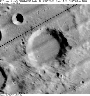
Nöggerath
Contents
Nöggerath
|
Lat: 48.8°S, Long: 45.7°W, Diam: 30 km, Depth: 1.94 km, Rükl: 70 |
Table of Contents
[#Nöggerath Nöggerath]
[#Nöggerath-Images Images]
[#Nöggerath-Maps Maps]
[#Nöggerath-Description Description]
[#Nöggerath-Description: Wikipedia Description: Wikipedia]
[#Nöggerath-Additional Information Additional Information]
[#Nöggerath-Nomenclature Nomenclature]
[#Nöggerath-LPOD Articles LPOD Articles]
[#Nöggerath-Bibliography Bibliography]

LO-IV-160H The 4-km circular crater in the upper left is Nöggerath F. Along the left margin, the east rims of Nöggerath J (top) and Nöggerath H (bottom) are just visible.
Images
LPOD Photo Gallery Lunar Orbiter Images Apollo Images
Maps
(LAC zone 125A1) LAC map Geologic map
Description
Description: Wikipedia
Additional Information
Depth data from Kurt Fisher database
- Westfall, 2000: 1.94 km
- Viscardy, 1985: 1.5 km
- Cherrington, 1969: 1.09 km
- Satellite crater Noggerath J is on the ALPO list of banded craters
Nomenclature
Johann Jakob; German geologist, mineralogist, seismologist (1788-1877).
LPOD Articles
Bibliography
A Portfolio of Lunar Drawings (Harold Hill), page 158 (the morning terminator from Zucchius & Segner to Noggerath).
This page has been edited 1 times. The last modification was made by - tychocrater tychocrater on Jun 13, 2009 3:24 pm - afx3u2