Greaves
Contents
Greaves (in the southwestern part of Mare Crisium)
(formerly [/Lick Lick] D)
|
Lat: 13.2°N, Long: 52.7°E, Diam: 13 km, Depth: 2.41 km, [/R%C3%BCkl%2037 Rükl: 37] |
Table of Contents
[#Greaves (in the southwestern part of Mare Crisium) Greaves (in the southwestern part of Mare Crisium)]
[#Greaves (in the southwestern part of Mare Crisium)-Images Images]
[#Greaves (in the southwestern part of Mare Crisium)-Maps Maps]
[#Greaves (in the southwestern part of Mare Crisium)-Description Description]
[#Greaves (in the southwestern part of Mare Crisium)-Description: Wikipedia Description: Wikipedia]
[#Greaves (in the southwestern part of Mare Crisium)-Additional Information Additional Information]
[#Greaves (in the southwestern part of Mare Crisium)-Nomenclature Nomenclature]
[#Greaves (in the southwestern part of Mare Crisium)-LPOD Articles LPOD Articles]
[#Greaves (in the southwestern part of Mare Crisium)-Bibliography Bibliography]

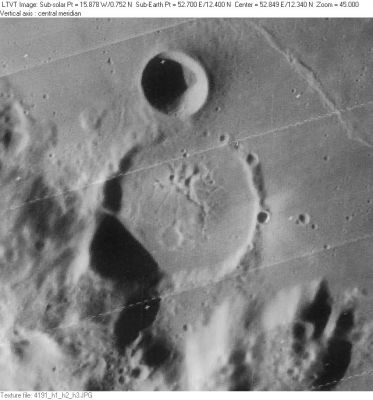
LO-IV-191H Greaves is the bowl-shaped crater at the top of the frame, with the large ghostly ring of [/Lick Lick] south of it. Ruined 23-km [/Lick Lick] A is partially visible just below [/Lick Lick]. The wrinkle-ridge in the upper right is not part of any named system.
Images
LPOD Photo Gallery Lunar Orbiter Images Apollo Images (see: Lick D)
- A fully illuminated Greaves (Lick D) was captured in Apollo 17's panoramic ITEK camera frame AS17-P-2687. You can't miss Greaves because here it is the most eye-catching formation!
- Greaves was also captured in Apollo 17's oblique south-looking Mapping/ Metric Fairchild camera frame AS17-M-1639 (rightward of the frame's centre).
- Additional research: Danny Caes
Maps
([/LAC%20zone LAC zone] 62A1) LAC map Geologic map LM map LTO map
Description
Description: Wikipedia
Additional Information
- Depth data from [/Kurt%20Fisher%20crater%20depths Kurt Fisher database]
- Westfall, 2000: 2.41 km
- Viscardy, 1985: 1.96 km
- The shadow in Greaves indicates a depth of about 2500 m. - JimMosher JimMosher
Nomenclature
- William Michael Herbert Greaves (10 September 1897 – 24 December 1955) was a British astronomer. He is most noted for his work on stellar spectro-photometry.
- This replacement name for a formerly [/lettered%20crater lettered crater] was introduced on LTO-62A1. - JimMosher JimMosher
LPOD Articles
Bibliography
This page has been edited 1 times. The last modification was made by - tychocrater tychocrater on Jun 13, 2009 3:24 pm - afx3