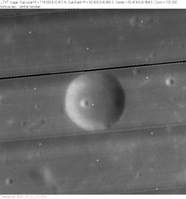
Ibn Battuta
Contents
Ibn Battuta
(formerly Goclenius A)
|
Lat: 6.9°S, Long: 50.4°E, Diam: 11 km, Depth: 1.51 km, Rükl: 48 |
Table of Contents
[#Ibn Battuta Ibn Battuta]
[#Ibn Battuta-Images Images]
[#Ibn Battuta-Maps Maps]
[#Ibn Battuta-Description Description]
[#Ibn Battuta-Description: Wikipedia Description: Wikipedia]
[#Ibn Battuta-Additional Information Additional Information]
[#Ibn Battuta-Nomenclature Nomenclature]
[#Ibn Battuta-LPOD Articles LPOD Articles]
[#Ibn Battuta-Bibliography Bibliography]

LO-IV-060H Ibn Battuta is the circular crater in the center. The other features in this view are unnamed.
Images
LPOD Photo Gallery Lunar Orbiter Images Apollo Images
Ibn Battuta's curious high-albedo craterlet at the western part of its floor is also noticeable on AS15-M-2537, in which Ibn Battuta was captured above and slightly to the right of the frame's centre.
Additional research: Danny Caes
Maps
(LAC zone 80A4) LAC map Geologic map LTO map
Description
Description: Wikipedia
Additional Information
Depth data from Kurt Fisher database
- Westfall, 2000: 1.51 km
Nomenclature
Abu Abd Allah Mohammed Ibn Abd Allah; Moroccan geographer (1304-1377).
- This replacement name for a formerly lettered crater first appeared on LTO-42C2. - JimMosher JimMosher
LPOD Articles
Bibliography
This page has been edited 1 times. The last modification was made by - tychocrater tychocrater on Jun 13, 2009 3:24 pm - afx3u2