Dorsa Sorby
Contents
Dorsa Sorby
|
Lat: 19.0°N, Long: 14.0°E, Length: 80 km, Height: km, [/R%C3%BCkl%2023 Rükl: 23] |
Table of Contents

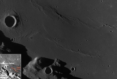
LROC image WAC No. M117406530ME (with Lunar Orbiter image inset for location purposes). Calibrated by LROC_WAC_Previewer.
Images
LPOD Photo Gallery Lunar Orbiter Images Apollo Images
Dorsa Sorby on Apollo photography (morning and pre-noon at Dorsa Sorby)
Orbital mapping/metric frames made by Apollo 17's Fairchild camera:
AS17-M-0806 (post sunrise photograph, Montes Haemus near upper left corner, Sulpicius Gallus above the frame's centre, Dorsa Sorby leftward of centre).
AS17-M-1231 (almost identical to frame 0806, although the sun's altitude is a bit higher).
AS17-M-1512 (sun's ascending...).
AS17-M-1815 (sun's ascending, shadows shorten, the western inner slopes of Sulpicius Gallus well illuminated, Dorsa Sorby gradually "disappearing"...).
AS17-M-2262 (this frame was made a bit northward of the preceding ones, it still shows Sulpicius Gallus and Dorsa Sorby, but... the dorsa is almost invisible due to the sun's high altitude).
AS17-M-2698 (almost identical to frame 2262, although the sun's altitude is a bit higher).
AS17-M-2892 (this frame was made a bit southward of the preceding ones, again it still shows Sulpicius Gallus and Dorsa Sorby, but... because of the local noon light (or pre-noon light) there's almost nothing to see of the dorsa).
Research: Danny Caes
Maps
([/LAC%20zone LAC zone] 42D4) LAC map Geologic map LM map LTO map
Description
Description: Wikipedia
Additional Information
Nomenclature
- Henry Clifton; British Earth scientist (1826-1908).
  - The name Dorsa Sorby is not printed on chart 23 of Antonin Rukl's Atlas of the Moon.- DannyCaes DannyCaes May 26, 2010
LPOD Articles
Bibliography
This page has been edited 1 times. The last modification was made by - tychocrater tychocrater on Jun 13, 2009 3:24 pm - afx3u2