Drygalski
Contents
Drygalski
|
Lat: 79.3°S, Long: 84.9°W, Diam: 149 km, Depth: 5.17 km, [/R%C3%BCkl%2072 Rükl: 72] |
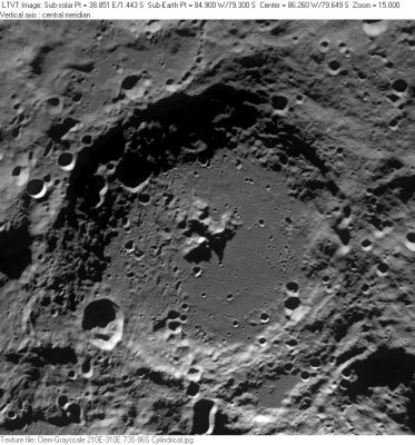
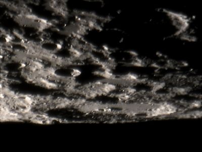
Right: Tom Bash In this Earth-based view, a favorable libration has brought Drygalski (with its central peak) into view on the Moon's south limb. Because Drygalski is located to the west of the Moon's south pole, a line towards the Moon's north pole is oriented almost horizontally to the left. Hence the image is rotated nearly 90° counter-clockwise relative to the satellite view. Drygalski P can be seen on the main crater's lower right floor. Most of the many craters immediately above Drygalski are unnamed. The half-shadowed 33-km crater at 10-11 o'clock from Drygalski's central peak (with the longer double-peaked shadow on its right) is [/Le%20Gentil Le Gentil] A with 26-km [/Wilson Wilson] C beyond it on the same line. The shadowed filled ellipse in the upper right corner is 108-km diameter [/Casatus Casatus].
Table of Contents
[#Drygalski Drygalski]
[#Drygalski-Images Images]
[#Drygalski-Maps Maps]
[#Drygalski-Description Description]
[#Drygalski-Description: Wikipedia Description: Wikipedia]
[#Drygalski-Additional Information Additional Information]
[#Drygalski-Nomenclature Nomenclature]
[#Drygalski-LPOD Articles LPOD Articles]
[#Drygalski-Lunar 100 Lunar 100]
[#Drygalski-Bibliography Bibliography]
Images
LPOD Photo Gallery Lunar Orbiter Images
Maps
([/LAC%20zone LAC zone] 143C3) USGS Digital Atlas PDF
Description
Description: Wikipedia
Additional Information
Depth data from [/Kurt%20Fisher%20crater%20depths Kurt Fisher database]
- Westfall, 2000: 5.17 km
- Viscardy, 1985: 3.9 km
Nomenclature
- Named for Erich von Drygalski (February 9, 1865 – January 10, 1949), a German geographer, geophysicist and polar scientist. Between 1882 and 1887, Drygalski studied mathematics and natural science. He graduated with a doctorate thesis about ice shields in Nordic areas. Drygalski led two expeditions between 1891 and 1893, which were supplied by the Society for Geoscience of Berlin. One expedition wintered over in Western Greenland between 1892 and 1893 .
- Name given by Fauth and included in [/Rectified%20Lunar%20Atlas Rectified Lunar Atlas] (1963) and approved in [/IAU%20Transactions%20XIIB IAU Transactions XIIB] (1964). According to the report by Arthur, this crater was known as [/Casatus Casatus] by [/Johann%20Schr%C3%B6ter Johann Schröter], as [/Cabeus Cabeus] by Franz, and as [/Casatus Casatus] G (Catalog number 3294a) in the original IAU nomenclature of [/Named%20Lunar%20Formations Named Lunar Formations] (in which [/Casatus Casatus] and [/Cabeus Cabeus] were used for other features).
LPOD Articles
Saturation and Filling In. Polar Triptych. Mountains Near the South Pole. Polar Dryness On Top of the World Limb Magic A Gift for the Holiday
Volcano M3? (Kaguya's look at Drygalski, with splendid row of colorful catadioptric effects!)
Lunar 100
[/Lunar%20100 L94]: Large south-pole region crater.
Bibliography
- Wood, C.A. 7/2005. Polar Pleasures. S&T 110(1):62-63
- Alan M. MacRobert. Exploring the Moon's South Pole. Sky and Telescope, October 1993, pages 66-67.
This page has been edited 1 times. The last modification was made by - tychocrater tychocrater on Jun 13, 2009 3:24 pm - afx3u2

