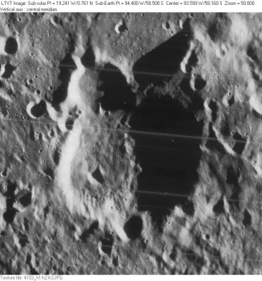
Blanchard
Contents
[hide]Blanchard
(formerly [/Arrhenius Arrhenius] P)
| Lat: 58.5°S, Long: 94.4°W, Diam: 40 km, Depth: km, Rükl: (farside) |
Table of Contents
[#Blanchard Blanchard]
[#Blanchard-Images Images]
[#Blanchard-Maps Maps]
[#Blanchard-Description Description]
[#Blanchard-Description: Wikipedia Description: Wikipedia]
[#Blanchard-Additional Information Additional Information]
[#Blanchard-Nomenclature Nomenclature]
[#Blanchard-LPOD Articles LPOD Articles]
[#Blanchard-Bibliography Bibliography]

LO-IV-193H
Images
LPOD Photo Gallery Lunar Orbiter Images
Maps
([/LAC%20zone LAC zone] 135C1) USGS Digital Atlas PDF
Description
Description: Wikipedia
Additional Information
- From the shadows in LO-IV-193H, the east rim of Blanchard is 2300-2600 m above the floor. - JimMosher JimMosher
Nomenclature
- Named for Jean-Pierre-François Blanchard (1753-1809), a French aeronaut.
- This name was published in the [/IAU IAU]'s 1991 Reports on Astronomy.
- Although listed in the [/IAU%20Planetary%20Gazetteer IAU Planetary Gazetteer] as replacing the former [/lettered%20crater lettered crater] designation [/Arrhenius Arrhenius] P, that name was actually part of [/Ewen%20Whitaker Ewen Whitaker]'s effort to letter the farside for [/NASA%20RP-1097 NASA RP-1097] (1982) and was never approved by the [/IAU IAU]. The [/IAU%20Planetary%20Gazetteer IAU Planetary Gazetteer] listing also gives a map reference of "SOV 1985" for this and the other seven new names published in 1991. This would seem to be a reference to an unidentified Soviet map from 1985.
LPOD Articles
Bibliography
This page has been edited 1 times. The last modification was made by - tychocrater tychocrater on Jun 13, 2009 3:24 pm - afx3u2