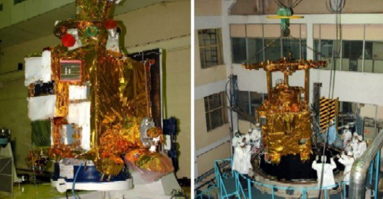
Chandrayaan-1
Revision as of 19:41, 10 April 2018 by Api (talk | contribs) (Created page with "<div id="content_view" class="wiki" style="display: block"> =Chandrayaan-1= Chandrayaan-1.jpg<br /> Credit: ISRO<br /> <div id="toc"> =Table of...")
Contents
Chandrayaan-1

Credit: ISRO
Table of Contents
[#Chandrayaan-1 Chandrayaan-1]
[#Chandrayaan-1-Description Description]
[#Chandrayaan-1-Additional Information Additional Information]
[#Chandrayaan-1-LPOD Articles LPOD Articles]
[#Chandrayaan-1-Bibliography Bibliography]
Description
The Chandrayaan-1 lunar probe, launched by the Indian Space Research Organisation (ISRO) on October 22, 2008, began operation in lunar orbit on November 8, 2008. It carried an international suite of eleven major scientific instruments, six of which (along with the launch vehicle) were designed and built in India. One of the eleven experiments was a separate sub-satellite, the Moon Impact Probe, which was released and intentionally crashed into the south polar crater Shackleton on November 14, 2008. Most of the remaining instruments emphasized chemical and mineralogical mapping. They also hoped to construct, by analysis of stereoscopic images, a complete topographic map of the Moon at a resolution of 5 m horizontally and 10 m vertically. The stereoscopic images were acquired with high Sun (similar to the [/Clementine Clementine] mission).
Additional Information
- The February 25, 2009 issue of the Indian magazine Current Science includes a two page panel showing initial results from each of the instruments and a series of in-depth articles describing the technical operations of each.
- Radio contact with Chandrayaan-1 spacecraft was lost on August 29, 2009, a few days after a failed attempt to perform a joint experiment with NASA's [/LRO Lunar Reconnaissance Orbiter].
- Mission page on JPL PDS imaging node -- currently contains data for the Moon Mineralogy Mapper (M3) instrument only.
- JPG versions of selected frames and bands are available in the Browse directory.
- A technical description of the instrument and the data released via the PDS can be found in DPSIS.PDF (12 MB).
- On Windows PC's, the M3 files in the *.IMG format (the imagery is in ones ending in "_RDN.IMG"), data for individual bands can be converted to text or 8-bit grayscale with this utility, although it may require determining the format from the corresponding text file ending in "_L1B.LBL" (the various files differ mostly in number of lines, which can be inferred from the file size using the Reset button in the utility).
- As explained in the "_L1B.LBL" files, in addition to the "_RDN.IMG" intensity data there are "_LOC.IMG" files giving the selenographic coordinates (and [/LOLA LOLA] elevation) of each image pixel, "_OBS.IMG" files giving the observing geometry (solar lighting, LOLA surface slope and other parameters), and "_TIM.TAB" (ASCII) files giving the Universal Time at which each line was captured.
- The "_RDN.IMG" files can also be opened on a variety of computer types with NASAView, which has the additional capability of selecting any three of the 85 (in "Global mode") spectral bands as the drivers of your computer screen's red-green-blue channels, creating a synthetic color image. NASAView can be used to open M3 files in two ways:
- Manually change the name of the associated "_L1B.LBL" file to "_RDN.LBL" ("_L1B" is an abbreviation for "Level 1B"), then under File..Open Object... select the "_RDN.IMG" file (which must reside in the same directory as the renamed *.LBL). This seems to be the best way, and gives access to the bands.
- Under File..Open object... select the desired "_L1B.LBL" file (which must reside in the same directory with the associated *.IMG files). Since "_L1B.LBL" file describes all the associated files, this method works only if NASAView can find copies of all of them ("_RDN.IMG", "_LOC.IMG", "_OBS.IMG" and "_TIM.TAB") in the current directory. Otherwise it will abort the loading with an error message. If successfully loaded, the individual files can be selected under "Label..Object Hierachy.." (by double-clicking on the displayed items), but you may not have access to the band data.
- In addition to the "_L1B.LBL" files, the PDS folders contain files with the extension "*.HDR" that also give an ASCII summary of the *.IMG file contents. As explained in the M3 documentation, the information in the *.HDR files is used for opening the *.IMG files with the commercial ENVI GIS software from ITT Visual Information Solutions. There is (according to the M3 documentation) supposed to be a free viewer called ENVI Freelook but it's not obvious it still exists.
- The documentation recommends opening the corresponding "_RDN.IMG", "_LOC.IMG" and "_OBS.IMG" files in three ENVI windows, then when a pixel of interest has been located in the intensity image ("_RDN.IMG") the support data can be accessed by retrieving the same row and column from the other two windows. The same operations can be achieved, though perhaps less elegantly, with the Windows utility mentioned above.
- [/Chandrayaan-2 Chandrayaan-2]
LPOD Articles
Bibliography
- Besse, S. et al (2011). Deriving a Photometric Model for the Moon Mineralogy Mapper Data (M3) – 42nd LPSC Conference (Mar), 2011
- Dhingra, D. et al (2011). Non-Linear Spectral Un-Mixing Using Hapke Modeling: Application to Remotely Acquired M3 Spectra of Spinel Bearing Lithologies on the Moon – 42nd LPSC Conference (Mar), 2011.
- Farrell, W. M. et al (2011). Could Lunar Polar Ice be a ‘Fountain’ Source for the Dayside Water Veneer? – 42nd LPSC Conference (Mar), 2011.
- Grumpe, A. et al (2011). Analysis of Topographic Effects Observed in Spectral Features Extracted from Chandrayaan-1 M3 Imagery – 42nd LPSC Conference (Mar), 2011
- Kramer, G. Y. et al(2011). Analysis of Schrodinger Basin Using Moon Mineralogy Mapper Spectra – 42nd LPSC Conference (Mar), 2011.
- Thompson, D. R. et al (2011). Automatic Detection of Water and Mafics in M3 Radiance Images – 42nd LPSC Conference (Mar), 2011
- Wikipedia article
- Chandrayaan-1 home page
- Chandrayaan-1 news (no longer active)
This page has been edited 1 times. The last modification was made by - tychocrater tychocrater on Jun 13, 2009 3:24 pm - mgx2