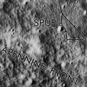
Spur
Contents
Spur (Apollo 15 site craterlet name)
|
Lat: 25.974°N, Long: 3.657°E, Diam: 0.088 km, Depth: ? km, [/R%C3%BCkl%2022 Rükl: 22] |
Table of Contents
[#Spur (Apollo 15 site craterlet name) Spur (Apollo 15 site craterlet name)]
[#Spur (Apollo 15 site craterlet name)-Images Images]
[#Spur (Apollo 15 site craterlet name)-Maps Maps]
[#Spur (Apollo 15 site craterlet name)-Description Description]
[#Spur (Apollo 15 site craterlet name)-Description: Wikipedia Description: Wikipedia]
[#Spur (Apollo 15 site craterlet name)-Additional Information Additional Information]
[#Spur (Apollo 15 site craterlet name)-Nomenclature Nomenclature]
[#Spur (Apollo 15 site craterlet name)-LPOD Articles LPOD Articles]
[#Spur (Apollo 15 site craterlet name)-Bibliography Bibliography]

Apollo 15 Site Traverses Chart
Images
LPOD Photo Gallery Lunar Orbiter Images Apollo Images
Maps
([/LAC%20zone LAC zone] 41B4) LAC map Geologic map LM map LTO map Lunar Photomap
Description
"Spur" is the astronaut-named designation for a small impact crater on the north slope of [/Mons%20Hadley%20Delta Mons Hadley Delta], a short distance from the Apollo 15 landing site. The crater is located about 300 m up the slope, and is situated about 70 m above the plain of [/Putredinis%2C%20Palus Palus Putredinis]. Numerous samples were collected from the rim of this crater, and are considered characteristic of the highland portion of the [/Apennine%20Front Apennine Front] geologic unit. Other samples were collected on the plain near the [/Dune Dune] and [/Elbow Elbow] craters.
Description: Wikipedia
Spur (correct link)
Additional Information
- This feature should not be confused with [/Spurr Spurr] the name for a 13-km diameter crater (formerly called Archimedes K) that is also located in [/Putredinis%2C%20Palus Palus Putredinis], but much closer to [/Archimedes Archimedes]. Both names were somewhat confusingly added to [/IAU%20Nomenclature IAU Nomenclature] in 1973.
- The IAU's [/IAU%20Nomenclature Planetary Gazetteer] gives Lunar Photomap (Site Traverse) 41B4/S4 as the primary reference indicating the position of the [/Landing%20Site%20Name Landing Site Name] "Spur". The coordinates and diameter given on the title line of this page are the values on that map, as read by [/LTVT LTVT]. The "official" IAU data for Spur are: Lat=25.9°N, Long=3.7°E, Diam=0.1 km. Because of the limited precision of the longitude and latitude, Spur's position is indistinguishable (in the Gazetteer) from the nearby named feature [/Apennine%20Front Apennine Front].
- The name "Spur" is also printed on Topophotomap 41B4/S1, but the label is placed so far from the tiny crater that it could not be identified from that map alone. - JimMosher JimMosher
Nomenclature
- Astronaut-named feature at [/Apollo%2015%20site Apollo 15 site].
- This name should not be confused with [/Spurr Spurr], or the Apollo 15 related mountain mass S.S.E. of [/Mons%20Hadley%20Delta Mons Hadley Delta], unofficially called Silver Spur.
LPOD Articles
Bibliography
See also: [/Apennine%20Front Apennine Front]
  Kenneth F. Weaver: Apollo 15 explores the mountains of the moon (National Geographic, February 1972).
  David M. Harland: EXPLORING THE MOON; The Apollo Expeditions.
  Eric M. Jones: APOLLO LUNAR SURFACE JOURNAL (ALSJ).
This page has been edited 1 times. The last modification was made by - tychocrater tychocrater on Jun 13, 2009 3:24 pm - afx3u2