Boot Hill
Contents
Boot Hill
(NASA nickname, previously known as Maskelyne Theta)
| Lat: 0.67°N, Long: 30.22°E, Diam: 14.9 km, Depth: km. |
Table of Contents

- JohnMoore2 JohnMoore2
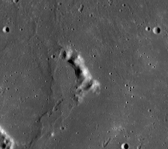
Boot Hill is the boot-shaped hill at the centre of this LROC frame. The hill at the lower left corner is Duke Island (another one of the NASA-nicknamed hills beneath the path of Apollo 11's east-west approaching LM Eagle).
Images
LROC view
- Apollo 10's orbital view of both Boot Hill and nearby Duke Island: AS10-28-4042
- Apollo 10's Command/Service Module (Charlie Brown) "in between" Boot Hill and Duke Island: AS10-29-4170
- Apollo 11's frequently reproduced and well-known orbital overview of the region east of LM Eagles landingsite, which shows Maskelyne near the lower right corner of the frame, and above the centre of the lower margin the hill Maskelyne Theta ('Boot Hill): AS11-37-5437
- Apollo 11's westward orbital view of both Maskelyne (upper right) and shadowless Boot Hill (lower right): AS11-41-6113
- Apollo 11's orbital close up of Boot Hill: AS11-42-6318
- Apollo 11's orbital overview of the Censorinus-Maskelyne region, with Boot Hill leftward of the frame's centre: AS11-44-6619
Was Boot Hill also photographed during the equatorial missions of Apollo 12 and Apollo 14? Does it appear on southward looking Fairchild-camera photographs made during Apollo 15? Or northward looking photographs from Apollo 16?
- Apollo 15's orbital Fairchild-camera frame AS15-M-2551 shows an oblique SW view of Maskelyne and Boot Hill.
- Two northward oblique views of Maskelyne and Boot Hill are Apollo 16's Fairchild-camera frames AS16-M-0820 and AS16-M-1384.
- In Apollo 17's SW looking Fairchild-frame AS17-M-2405, both Maskelyne and Boot Hill are noticeable very near the central part of the curved horizon.
Maps
- Chart SLC-B4 (System of Lunar Craters) (as Maskelyne Theta).
- Charts 58 and 59 in the Times Atlas of the Moon (as a nameless hill).
- Antonin Rukl's Chart 36 in his Atlas of the Moon. The hill south of Maskelyne (Maskelyne Theta) is depicted near the chart's lower margin, but... not named.
- The lower left corner of LAC 61 (page 123) in Ben Bussey's and Paul Spudis's Clementine Atlas of the Moon (the hill immediately below Maskelyne) (depicted, not named).
Description
Boot Hill (or Maskelyne Theta) is an easy object to observe, especially while looking through a common telescope in a public observatory.
The best time to observe Boot Hill is slightly before First Quarter Moon (westward shadow at the hill) and after Waning Gibbous Moon (eastward shadow at the hill).
Wikipedia
Boot Hill (lunar mountain)
Additional Information
Nomenclature
Mentioned as Maskelyne Theta on Chart SLC-B4 in the System of Lunar Craters.
  Not recognized as Maskelyne Theta on charts 58 and 59 in the Times Atlas of the Moon (a nameless hill).
  Nicknamed Boot Hill during the heydays of NASA's Project Apollo (especially during the missions of Apollo 10 and Apollo 11).
  Note by Jim Mosher:
  - "Boot Hill" may indeed refer to a boot-shaped hill; but in the folklore of the American Wild West (which the astronauts seem to have drawn on for many of their other landmark nicknames) "Boot Hill" is a generic name for the cemetery or burying ground just outside of town where the bad (and good) guys come to rest.
  In that case I think it refers more to the boots of the deceased than to the shape of the terrain.
 Boot Hill (cemetery)
LPOD Articles
LROC Articles
Bibliography
This page has been edited 1 times. The last modification was made by - tychocrater tychocrater on Jun 13, 2009 3:24 pm - afx3u2