Rupes Boris
Contents
Rupes Boris
|
Lat: 30.5°N, Long: 33.5°W, Length: 4 km, Height: km, [/R%C3%BCkl%209 Rükl: 9] |
Table of Contents
[#Rupes Boris Rupes Boris]
[#Rupes Boris-Images Images]
[#Rupes Boris-Maps Maps]
[#Rupes Boris-Description Description]
[#Rupes Boris-Description: Wikipedia Description: Wikipedia]
[#Rupes Boris-Additional Information Additional Information]
[#Rupes Boris-Nomenclature Nomenclature]
[#Rupes Boris-LPOD Articles LPOD Articles]
[#Rupes Boris-Bibliography Bibliography]

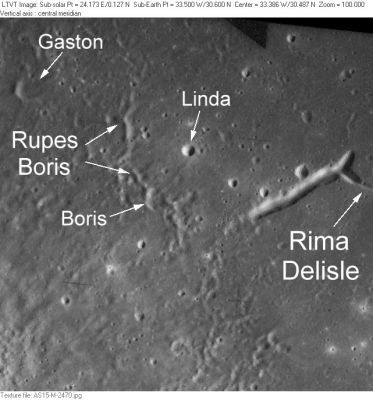
AS15-M-2470 This small region northeast of [/Delisle Delisle] was the subject of a Topophotomap which is the source of several IAU-approved [/minor%20feature minor feature] names: [/Boris Boris], [/Gaston Gaston], [/Linda Linda] and [/Rupes%20Boris Rupes Boris]. Rupes Boris refers to a minor step in elevation detected in the stereo mapping. The shadows in this photo make it appear more of a ridge. The large trench-like depression at one end of [/Rima%20Delisle Rima Delisle] is unnamed.
Images
LPOD Photo Gallery Lunar Orbiter Images Apollo Images
Maps
([/LAC%20zone LAC zone] 39B2) LAC map Geologic map LM map LTO map Topophotomap
Description
Rupes Boris is not a fault. It is a ridge that is part of the ejecta of the fresh crater Delisle. In any case this feature is too minor to warrant a name, much less a name that gives an incorrect classification.
Description: Wikipedia
Additional Information
Nomenclature
Named from nearby crater. ([/Boris Boris])
- According to [/NASA%20RP-1097 NASA RP-1097], "Rupes Boris" is a [/Minor%20Feature Minor Feature] whose name was originally intended only for use in connection with Topophotomap 39B2/S2(on which it is plotted).
LPOD Articles
Bibliography
This page has been edited 1 times. The last modification was made by - tychocrater tychocrater on Jun 13, 2009 3:24 pm - afx3u2