Rectified Lunar Atlas
Contents
Whitaker, Kuiper, Hartmann & Spadley: Rectified Lunar Atlas (1963)
(glossary entry)
Description
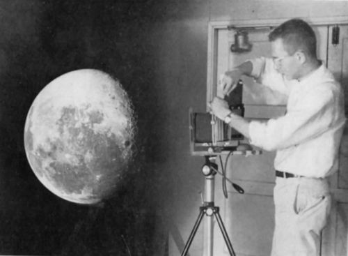
As part of [/Gerard%20Kuiper G. P. Kuiper]'s Moon-mapping program of the late 50s and 60s a unique atlas of the limb regions was made, the Rectified Lunar Atlas by Whitaker, Kuiper, Hartmann and Spradley. This large format, bound atlas showed each limb area as seen from directly overhead. Since this was made before lunar orbiters flew it was necessary to create it by projecting telescopic images of the Moon onto a large white sphere and then rephotographing the sphere from directly over the area of interest. In doing this Bill Hartmann discovered the multi-ring structure of [/Mare%20Orientale Mare Orientale] and other [/lunar%20basins basins]. This vertical view also allowed us crater catalogers (compiling the [/System%20of%20Lunar%20Craters System of Lunar Craters]) to clean up many inconsistencies of limb nomenclature and recognize craters deserving names. [/D.W.G.%20Arthur D.W.G. Arthur] and [/Ewen%20Whitaker E.A. Whitaker] gave 68 new names or shifted earlier names to real formations in the Atlas. Information from personal experience and ([/Whitaker Whitaker], 1999, pp. 234-5). - tychocrater tychocrater Jul 28, 2007
- {| class="captionBox"
| class="captionedImage" |
 |-
| class="imageCaption" | Hartmann with globe, from Kuiper (1964)
|}
Additional Information
- The atlas consists of 30 fields of 30x30° each illustrated on 30x38 cm sheets. Each field is shown with at least three illuminations (waxing, Full Moon, and waning) and accompanied by a gridded line drawing identifying the features.
- [/D.W.G.%20Arthur D.W.G. Arthur] presented a report on nomenclatural changes introduced in the Rectified Lunar Atlas work, which was approved at the [/IAU%20Transactions%20XIIB 1964] IAU meeting.
- The idea of rectifying lunar photographs by projecting them onto a globe seems to have been pioneered by Dr. [/Wright F. E. Wright], who recorded the data directly with a photographic emulsion on the globe. Alter and Roques (1955) photographed Wright's globes from overhead the features of interest, and (according to the [/North%20American%20Atlas North American Atlas]) in areas where Wright's globes had insufficient detail photographed new images projected onto a white wooden sphere.
- According to Carder (1962), the [/DMA DMA] had facilities for rectifying images by projection onto a sphere independent of those at the [/LPL LPL].
LPOD Articles
Bibliography
- Whitaker, E. A.; Kuiper, G. P., Hartmann, W.K. & Spradley, L. H. 1963. Rectified Lunar Atlas - Supplement Number Two to the [/Photographic%20Lunar%20Atlas Photographic Lunar Atlas]. Aeronaut. Chart Inform. Center.
- Alter, Dinsmore; Roques, Paul E. 1955. The Limb of the Moon. Publications of the Astronomical Society of the Pacific, Vol. 67, No. 397, p. 246 (with Plates 15, 16, 17 and 18)
- Carder, R. W. 1962. Lunar Charting on a Scale of 1:1000000. In: The Moon, (Kopal, Z., and Mikhailov, Z. K., editors) IAU Symposium 14, Academic Press, pp. 117-129.
- Kuiper, G. P. 1964. "The Lunar and Planetary Laboratory." Sky and Telescope Vol. 27. Part 2: February issue, pp. 88-92.
- MacRae, D. A. 1964. Review of Publications- Rectified Lunar Atlas. Journal of the Royal Astronomical Society of Canada, Vol. 58, p. 278.
- Spradley, L. H. "Lunar Globe Photography". [/LPL Communications of the Lunar and Planetary Laboratory]. 1(6), 31 -34. (PDF, shows a prototype image set for the atlas)
This page has been edited 1 times. The last modification was made by - tychocrater tychocrater on Jun 13, 2009 3:24 pm - mgx1//