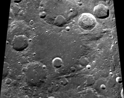
Poczobutt
Contents
Poczobutt
| Lat: 57.1°N, Long: 98.8°W, Diam: 195 km, Depth: 3.12 km, Rükl: (farside) |
Table of Contents
[#Poczobutt Poczobutt]
[#Poczobutt-Images Images]
[#Poczobutt-Maps Maps]
[#Poczobutt-Description Description]
[#Poczobutt-Description: Wikipedia Description: Wikipedia]
[#Poczobutt-Additional Information Additional Information]
[#Poczobutt-Nomenclature Nomenclature]
[#Poczobutt-LPOD Articles LPOD Articles]
[#Poczobutt-Bibliography Bibliography]

Clementine
Poczobutt at centre, with Cannizzaro at lower left (southwest), Omar Khayyam at left (west), and Smoluchowski at north (of Poczobutt itself). - DannyCaes DannyCaes Feb 12, 2014
Images
LPOD Photo Gallery Lunar Orbiter Images
- Poczobutt was photographed by Lunar Orbiter IV, see frame LO-IV-190-med, in which Poczobutt and its adjacent craters Cannizzaro, Omar Khayyam, and Smoluchowski are noticeable at the lower half of the frame, near the sunrise terminator.
- Research Lunar Orbiter IV photography: Danny Caes
Maps
([/LAC%20zone LAC zone] 21A3) USGS Digital Atlas PDF
Description
Description: Wikipedia
Additional Information
Depth data from [/Kurt%20Fisher%20crater%20depths Kurt Fisher database]
- Westfall, 2000: 3.12 km
Nomenclature
- Marcin Odlanicki Poczobutt (October 30, 1728 – February 7, 1810) was a Polish-Lithuanian astronomer, jesuit and mathematician. He became mathematics professor and rector of the Vilnius University where he organized the construction of the university's observatory and the purchase of the equipment. He also made observations of solar and lunar eclipses, comets and asteroids. In addition, he made measurements of Mercury to compute an orbit.
- A valley at the southern part of Poczobutt's rim is unofficially called Vallis Poczobutt by D.Caes.
LPOD Articles
Bibliography
This page has been edited 1 times. The last modification was made by - tychocrater tychocrater on Jun 13, 2009 3:24 pm - afx3u2