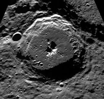
Plaskett
Contents
Plaskett
|
Lat: 82.1°N, Long: 174.3°E, Diam: 109 km, Depth: 4.7 km, Rükl: (farside), [/Stratigraphy Upper Imbrian] |
Table of Contents
[#Plaskett Plaskett]
[#Plaskett-Images Images]
[#Plaskett-Maps Maps]
[#Plaskett-Description Description]
[#Plaskett-Description: Wikipedia Description: Wikipedia]
[#Plaskett-Additional Information Additional Information]
[#Plaskett-Nomenclature Nomenclature]
[#Plaskett-LPOD Articles LPOD Articles]
[#Plaskett-Bibliography Bibliography]

Clementine
Images
LPOD Photo Gallery Lunar Orbiter Images
Maps
([/LAC%20zone LAC zone] 1D3) USGS Digital Atlas PDF
Description
A relatively fresh Copernicus-like crater at high latitude on the farside. It has typical wall terraces and central peaks. The texture on the relatively smooth floor suggests that it has not been infilled by downslope movement of wall materials; possibly it is impact melt. The odd line of 10 or so evenly spaced bumps on the NW edge of the floor is real, for it also appears on the recent SMART-1 image. The bumps line up with a possible lineation just outside the crater wall that roughly points back toward [/Ricco Ricco] but I don't know what formed the bumps. - tychocrater tychocrater Sep 1, 2007
Description: Wikipedia
Additional Information
- TSI = 30, CPI = 15, FI = 20; MI =65 [/Smith%20and%20Sanchez%2C%201973 Smith and Hartnell, 1973]
- Measures on LRO QuickMap give depth of about 4.7 km
- Measures on LRO QuickMap give central peak height about 2.3 km
Nomenclature
John Stanley Plaskett (November 17, 1865 – October 17, 1941) was a Canadian astronomer. His formal astronomical career did not start until 1903, when he was appointed to the staff at Dominion Observatory in Ottawa. His achievements are all the more remarkable for this very late start. He measured radial velocities and studied spectroscopic binaries.
LPOD Articles
North of the Pole
Ho Hum, Another Earthrise
Bibliography
This page has been edited 1 times. The last modification was made by - tychocrater tychocrater on Jun 13, 2009 3:24 pm - afx3u2