Parry
Contents
Parry
|
Lat: 7.9°S, Long: 15.8°W, Diam: 47 km, Depth: 0.87 km, [/R%C3%BCkl%2043 Rükl 43] |
Table of Contents

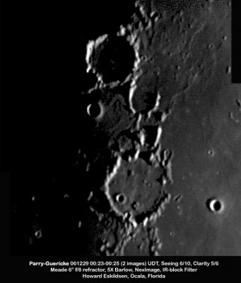
Howard Eskildsen, Parry (top) and [/Guericke Guericke]
Images
LPOD Photo Gallery Lunar Orbiter Images Apollo Images
Lunar Orbiter 5's Frame 138 shows a close-up of the well-known junction at Fra Mauro, Bonpland, and Parry.- DannyCaes DannyCaes Mar 23, 2008
Maps
([/LAC%20zone LAC zone] 76B4) LAC map Geologic map LM map AIC map
Description
Description: Elger
([/IAU%20Directions IAU Directions]) PARRY.--A more complete formation than [/Guericke Guerike]. It is about 25 miles in diameter, and is encompassed by a bright border, which, at a point on the W., is nearly 5,000 feet in height. It is intersected on the N. by passes communicating with the interior of [/Fra%20Mauro Fra Mauro]. There is a crater, nearly central, on the dusky interior, which, under a low sun, when the shadows of the serrated crest of the E. wall reach about half-way across the floor, appears to be the centre of three or four concentric ridges, which at this phase are traceable on the W. side of it. There is a conspicuous crater on the W. wall, below which originates a distinct cleft. This object skirts the inner foot of the W. border, and after traversing the N. wall, strikes across the wide expanse of [/Fra%20Mauro Fra Mauro], and is ultimately lost in the region N. of this formation. Parry A, S. of Parry, is a very deep brilliant crater with a central hill and surrounded by a glistening halo. A cleft, originating at a mountain arm connected with the W. side of [/Guericke Guerike], runs to the S. flank of this object, and is probably connected with that which skirts the floor of Parry on the W.
Description: Wikipedia
Additional Information
Depth data from [/Kurt%20Fisher%20crater%20depths Kurt Fisher database]
- Pike, 1976: 0.87 km
- Arthur, 1974: 0.56 km
- Westfall, 2000: 0.87 km
- Viscardy, 1985: 0.56 km
- Cherrington, 1969: 1.15 km
Nomenclature
- William Edward Parry (December 19, 1790 - July 9, 1855) was a British Arctic explorer. In 1810 received promotion to the rank of lieutenant in the frigate Alexander, which spent the next three years in the protection of the Spitsbergen whale fishery. He took advantage of this opportunity for the study and practice of astronomical observations in northern latitudes, and afterwards published the results of his studies in a small volume on Nautical Astronomy by Night (1816). In 1825 Parry obtained the sanction of the Admiralty for an attempt on the North Pole from the northern shores of Spitsbergen, and his extreme point of 82° 45’ N. lat. remained for 49 years the highest latitude attained. He published an account of this journey under the title of Narrative of the Attempt to reach the North Pole, &c. (1827).
- Parry M, the incomplete ring southeast of Parry, was nicknamed "The Horseshoe" by Harold Hill (see: A PORTFOLIO OF LUNAR DRAWINGS, Page 107).
LPOD Articles
Bibliography
APOLLO OVER THE MOON; A VIEW FROM ORBIT, Chapter 3: The Terrae (Part 2), Figure 44. Chapter 4: The Maria (Part 3), Figure 94.
  A Portfolio of Lunar Drawings (Harold Hill), pages 107, 108, 109.
This page has been edited 1 times. The last modification was made by - tychocrater tychocrater on Jun 13, 2009 3:24 pm - afx3u2