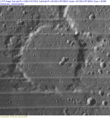
Oenopides
Contents
Oenopides
|
Lat: 57.0°N, Long: 64.1°W, Diam: 67 km, Depth: 1.38 km, [/R%C3%BCkl%201 Rükl: 1], [/Stratigraphy Nectarian or pre-Nectarian] |
Table of Contents

LO-IV-176H
Images
LPOD Photo Gallery Lunar Orbiter Images
Maps
([/LAC%20zone LAC zone] 10B4) USGS Digital Atlas PDF
Description
Description: Elger
([/IAU%20Directions IAU Directions]) OENOPIDES.--A large and tolerably regular walled-plain, 43 miles in diameter, on the E. of [/Xenophanes Xenophanes]. The depressions on the E. wall are worth examination at sunrise. There is apparently no detail whatever on the floor.
Description: Wikipedia
Additional Information
- Depth data from [/Kurt%20Fisher%20crater%20depths Kurt Fisher database]
- Westfall, 2000: 1.38 km
- Cherrington, 1969: 2.19 km
- Based on the shadows in LO-IV-176H, [/LTVT LTVT] finds that at one point, near the bright spot, the eastern rim rises to 2,700 m above the floor; but the rim height is generally closer to 1,700 m. Although Oenopides has no central peak, Elger was not completely correct about the complete lack of detail on the floor. - JimMosher JimMosher
Nomenclature
Oenopides of Chios (500(?)-430 B.C.) was an ancient Greek mathematician (geometer) and astronomer, who lived around 450 BCE. He was born shortly after 500 BC on the island of Chios, but mostly worked in Athens. The main accomplishment of Oenopides as an astronomer was his determination of the angle between the plane of the celestial equator, and the zodiac (the yearly path of the sun in the sky). He found this angle to be 24°. In effect this amounted to measuring the inclination of the earth axis. Oenopides's result remained the standard value for two centuries, until Eratosthenes measured it with greater precision.
LPOD Articles
Bibliography
This page has been edited 1 times. The last modification was made by - tychocrater tychocrater on Jun 13, 2009 3:24 pm - afx3u2