Barker's Quadrangle
Contents
Barker's Quadrangle
(unoffical name, also known as The Trapezium)
|
Lat: 12.6°N, Long: 60.3°E, Diameter: 50 km, Depth: km, [/R%C3%BCkl%2038 Rükl 38] |
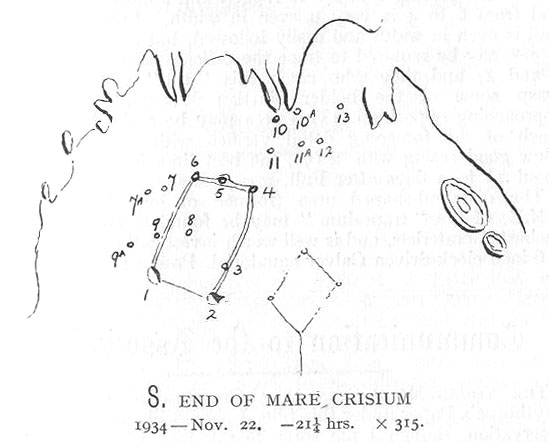
Robert Barker's south-up chart of the Trapezium shaped system of ridges and craterlets (1-2-4-6) that he observed in the southern part of [/Mare%20Crisium Mare Crisium], as published in the the Journal of the [/BAA BAA] in 1935 (courtesy Phil Morgan). Craterlet 1 is the modern [/Fahrenheit Fahrenheit], 2 is presumably [/Picard Picard] Y.
Table of Contents
Images
LPOD Photo Gallery Lunar Orbiter Images
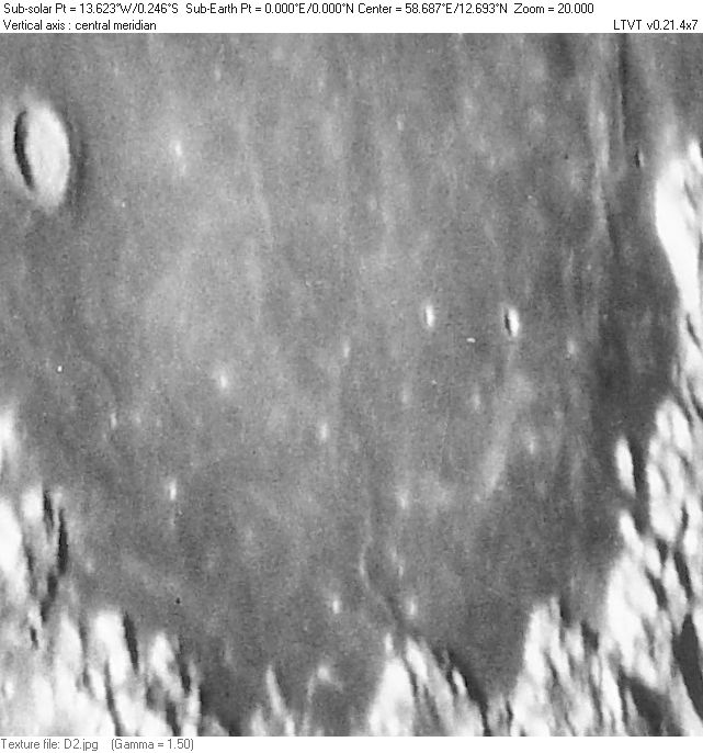
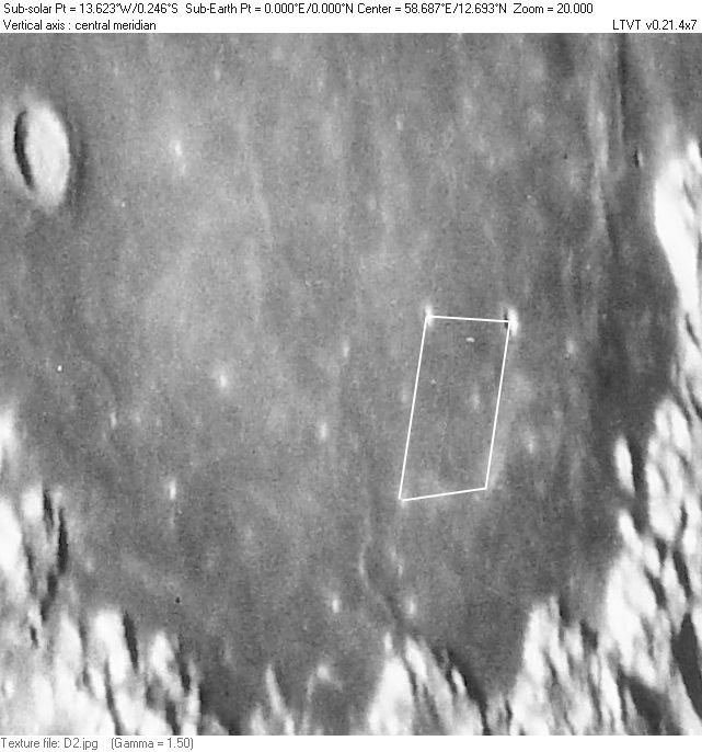
- Although some of the observers cited below recommend observing this region at low [/sun%20angle sun angle], the "feature" probably has its most "quadrangle" like appearance on the higher Sun view of Plate D2 from the [/Consolidated%20Lunar%20Atlas Consolidated Lunar Atlas]. According to the Lunar Orbiter imagery (see comparison below), the bright spot seen at the southwest corner (#4 on the Finder Chart, opposite [/Fahrenheit Fahrenheit]) is a pair of bright-haloed craters with diameters of 1.2 and 1.5 km with about 2.2 km between centers.
- An excellent amateur low sun view is available from Wes Higgins (the brightness needs to be adjusted to show this region well).
- Paolo Lazzarotti has an excellent amateur view of the bright features visible at high sun.
Maps
([/LAC%20zone LAC zone] 62B1) LAC map Geologic map LM map LTO map
Description
Barker's Quadrangle or the Trapezium is an informal name for a region on the floor of [/Mare%20Crisium Mare Crisium] that was once one of several that inspired speculation about [/LTP changes] on the Moon. The northeast corner of the quadrangle is marked, roughly, by 6.5 km diameter [/Fahrenheit Fahrenheit] and the northwest corner by 4 km [/Picard Picard] Y. The side of the "quadrangle" extending south from [/Fahrenheit Fahrenheit] is marked by a fairly prominent [/dorsum wrinkle ridge] that then trends to the west through a cratered area, creating another side. At least parts of this ridge appear to be regarded as components of the [/Dorsa%20Harker Dorsa Harker] system by the IAU. The remaining parts of the quadrangle are much more vague than Barker's description would suggest. In addition to Barker's original description, UK amateur Phil Morgan has located a number later descriptions of this feature, several of which are reproduced below. - JimMosher JimMosher
Description: Elger
([/IAU%20Directions IAU Directions])
Additional Information
- According to a 1957 account by Barker (unearthed by Nigel Longshaw, 2011), Barker's initial "discovery" was made "on 1929 March 26, 22½ hours" when he casually noticed on the floor of Mare Crisium a "well displayed trapezium" which, to his surprise, he was unable to find in any of the references/maps available to him. Figure 2 of that account recreates his initial drawing, which shows the size and position of the quadrangle relative to the apparently already well documented diamond of mare ridges to its west. Barker also mentions "a smaller rectangular formation, almost a duplicate of the above" just east of the main quadrangle (apparently seen at a later time and, according to Wilkins, extremely difficult to see). It is illustrated in Figure 3 (of Barker's account), along with about 16 other numbered craterlets that do not form part of the designated "formations."
- An early south-up drawing of the "trapezium" in [/Mare%20Crisium Mare Crisium] by Robert Barker, published, with description in JBAA for 1935, located and scanned by UK amateur Phil Morgan. The lighting at the time of this observation would have been very similar to that seen in [/Consolidated%20Lunar%20Atlas Consolidated Lunar Atlas] Plate D2. The article begins on page 124 of the January 1935 issue.
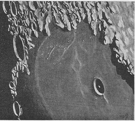
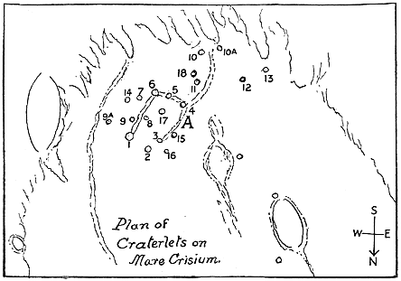
- South-up drawing of region by amateur L. F. Ball, with finder chart ("Trapezium" marked "A", note that the "east" and "west" notations are reversed compared to modern [/IAU%20directions IAU directions]) provided by Phil Morgan from page 15 of the October 1936 Memoirs of the BAA. The line drawing on the right is a Finder Chart. The Trapezium is marked "A". Craterlet 1 is evidently the modern [/Fahrenheit Fahrenheit]. The large crater(?) sketched with two lines of an oval at left may be 74 km [/Condorcet Condorcet]. [/Picard Picard] (22 km) is represented by the more complete oval with handle at lower right. On the compass rose, "E" and "W" are reversed from the [/IAU%20directions modern convention]. According to the text by then Lunar Section Director Walter [/Goodacre Goodacre], craterlets 1-13 had been reported by Barker. 14-18 were added by Ball. Although the drawing may at first look accurate, much of it seems stylized. It is, for example, very difficult to relate the craters shown along the terminator at left to specific features on the Moon. Likewise, it is impossible to have features there in sunlight simultaneously with the deep shadows shown in [/Picard Picard] and on the western shore of [/Mare%20Crisium Mare Crisium]. It is unknown if Ball's image is intended to represent a specific date and time or a composite of many observations made with low sun.
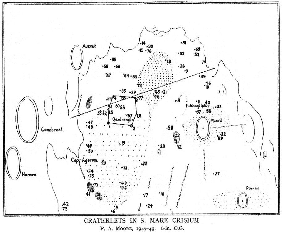
- Map of southern [/Mare%20Crisium Mare Crisium] published and described by Patrick Moore in 1949 ("The [/Picard Picard]-[/Promontorium%20Agarum Cape Agarum] area of the moon." J. Brit. Astron. Assoc. 59, pp. 250, 251, 252 -- scans provided by Phil Morgan, also available from NASA ADS). The area of interest is given a hexagonal shape and labeled "Quadrangle". Unfortunately there is no reference to Barker's original description and it is very difficult to identify most of the craters plotted by Moore. Although the size and position is not exactly as Moore shows it, his hexagonal shape is probably meant to correspond to the similar structure visible in these three (north-up) images of [/Mare%20Crisium Mare Crisium] by Dutch amateur Jan Timmermans: photo 1, photo 2, photo 3.
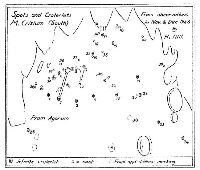
- Chart of southern [/Mare%20Crisium Mare Crisium] by [/Hill%2C%201991 Harold Hill] described by BAA Lunar Section Director [/Hugh%20Percy%20Wilkins H. P. Wilkins] in Memoirs of the BAA, Vol. 36, Part 3 1950 July: Eleventh Report of the Lunar Section, pages 6 and 7 (scans provided by Phil Morgan, also available from NASA ADS). Hill's chart is much more understandable than the earlier one by Moore, but the area regarded as comprising the "Trapezium" is not labeled on the map or described with clarity in the text (its corners are presumably marked by the craterlets labeled "1", "2", "3" an "4"). To understand the references to "the Director's new large scale map," see the entry for Wilkins and Moore (1961), below.
- Description of [/Mare%20Crisium Mare Crisium] from Patrick Moore's 1953 Guide to the Moon (pp. 102-103, converted to [/IAU%20directions IAU directions]):
- The Mare surface is fairly level, and on it there are only three craters of any size [/Picard Picard] itself; [/Peirce Peirce], to the north; and [/Swift Graham], a smaller formation to the north of [/Peirce Peirce]. The region south and south-east of [/Picard Picard] was shown more or less featureless by all observers up to the beginning of the present century. Edmund Neison, author of the first accurate British lunar map, recorded only a few low ridges, and even Walter Goodacre, in his famous map, put in only three white spots. Just over twenty years ago Robert Barker, observing with his 12-inch reflector at Cheshunt, in Hertfordshire, discovered a conspicuous 'quadrangle' made up of prominent craterlets connected by low ridges, where Madler had shown nothing at all. Examination of old drawings showed that parts of the quadrangle had been seen from time to time, but never before had it appeared so conspicuous or so complete. Nowadays it can be seen with a very small telescope, and the whole region is dotted with craterlets and white spots which cannot possibly be missed. In 1949, the writer published a chart [see Note] showing over seventy of them, and certainly they were not to be seen when Goodacre drew his map in 1910.
- There are two possible explanations. Either the craterlets are of recent formation which would prove that definite volcanic activity is still going on or they were there all the time, hidden beneath a layer of mistiness. Such mist would not have to be thick. A very tenuous layer of haze would be enough to conceal the minute details underneath.
- Of these two theories, the second appears much the more likely, and it is supported by dozens of independent observations of mists in the area. These observations go back eighty years to the time of Birt, who often noted that Graham, the crater south of Peirce, was totally invisible when it should have been obvious. This has also been found more recently for instance, Dr. Wilkins could see no trace of it on May 12 1927, though it had been normal on May 11 and had reappeared faintly by May 13. Three times in 1948 the writer saw the whole area "misty grey and devoid of detail", with the surrounding surface sharp and clear-cut; R. M. Baum, at Chester, saw a similar appearance twice, and on one night the 'quadrangle' alone was missing, its site being occupied by a nebulous white patch.
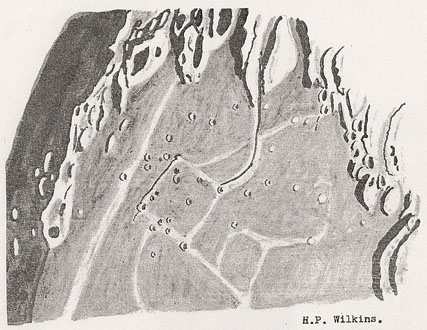
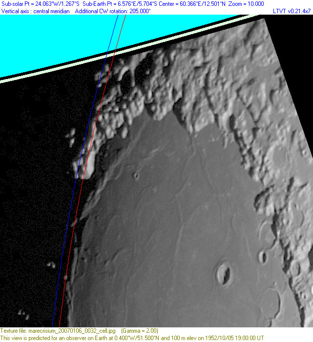
- South-up drawing of region by [/Hugh%20Percy%20Wilkins H. P. Wilkins] dated 1952 Oct 05 (scan provided by Phil Morgan from JALPO 10, Nos 9-10 (Sept - Oct, 1956) page 107), compared to a modern photo by Christina Cellini with similar lighting (2007 Jan 06 - 00:32 UT) corrected to Wilkins' libration. The red and blue lines show the theoretical position of the terminator if Wilkins observed the Moon shortly after it rose. The text accompanying the drawing indicates it was made with a 30-inch reflector at 300X.
- Description from 1961 Second Edition of [/Wilkins%20and%20Moore Wilkins and Moore] (page 197, converted to [/IAU%20directions IAU directions]):
- On the south-eastern portion of the [/Mare%20Crisium Mare] is a peculiar trapezium, formed of ridges, with craterlets on their crest or flanks. This diamond-shaped feature was first traced in its entirety by Barker, and there are some craterlets on its interior. A curved ridge connects its western corner with the mountain border of the mare, and immediately west of this ridge, which is low, Wilkins discovered a cleft of corresponding contour, deep and sharp where it issues forth from the mountains, with a lofty mountain on either side, but gradually becoming very delicate as it approaches the 'trapezium'.
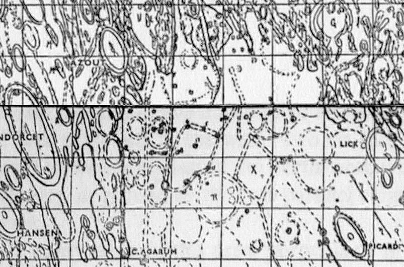
- The following image is a combination of slightly blurred scans of Sheets XI (top) and XII (bottom) of the reduced version of Wilkins' map that appear at the start of each chapter of this book. Despite what the description might imply, the "trapezium" is evidently not the diamond-shaped feature marked by the "X", but rather the larger irregular structure with numbered craterlets to its left, near the center of this image. The craterlets at the top of that object are labeled "6" and "5". The interior ones below them are labeled "8" and "7", and those forming the curved arc at lower right are "2", "3" and "15". "1" and "4" are probably the lower left and upper right corners of the "quadrangle", but their labels -- if any -- are hard to distinguish from the background. This system of numbering is not explained in the text and seems unrelated to that on any of the earlier maps cited above.
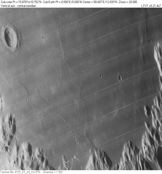
- South-up Lunar Orbiter image corrected to zero libration:
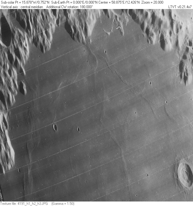 <-- click to see larger imageAside from [/Fahrenheit Fahrenheit] and [/Picard Picard] Y, none of the craterlets photographed by the [/Lunar%20Orbiter Lunar Orbiter] are more more than 2 km in diameter. Most are much less, which probably accounts for the inconsistencies between the drawings by Ball, Wilkins and others. The [/rima rille] (or "cleft") that Wilkins thought he had discovered in association with the ridge extending out of the south shore of [/Mare%20Crisium Mare Crisium] was not confirmed by the photos from space. The drawings by Harold Hill are much more realistic than those of his predecessors, and show [/Fahrenheit Fahrenheit] and [/Picard Picard] Y in close to their correct proportions. - JimMosher JimMosher
- Here is the southern part of [/Mare%20Crisium Mare Crisium] shown in a more conventional north-up zero libration view using Lunar Orbiter IV frame 191H and Plate D2 from the [/Consolidated%20Lunar%20Atlas Consolidated Lunar Atlas].
| LO-IV-191H |
CLA Plate D2 |
Marked |
- The "quadrangle" accented by bright ridges that was drawn by Ball and by Wilkins is most evident in the lower resolution Earth-based image (center) and marked on the version at right.
- The region as drawn and labeled by Wilkins in a "Folio" of charts published in 1958, shortly before his death:
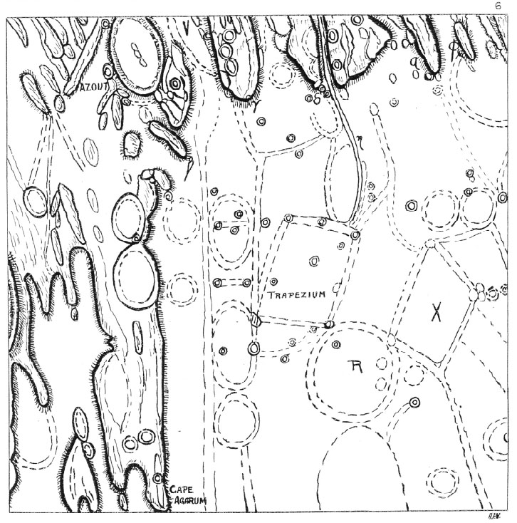 <-- from ALPO Monograph Number 3 (Part 4)
Nomenclature
- Attention was called to the region in the early 1930's by British amateur Robert Barker (1873-1966). He referred to the feature he saw there as a "trapezium."
 This portrait of Robert Barker as he appeared in 1938 was supplied by Phil Morgan, courtesy of his neighbor Richard Baum. They note that Barker was the longtime music critic of the Morning Post and the Manchester Guardian, as well as a avid cyclist whose sports career was cut short by a serious accident. He observed the Moon and planets with the 12.6-inch Calver Equatorial in his private observatory at Cheshunt, UK.
- Later observers seem to have used the name The Trapezium and Barker's Quadrangle, the latter popularized especially by Patrick Moore.
- The unofficial name Barker's Quadrangle was printed on a small Moon map in one of Patrick Moore's The Guinness book of astronomy facts & feats (see below; Bibliography). Research: Danny Caes
- It also appears on a chart of the of [/Mare%20Crisium Mare Crisium] region on pages 210-211, and a more detailed map (where six craters, of which four are numbered, are connected by lines) and text (pages 146-7) of Moore's 1963 Survey of the Moon.
- Washington-based amateur Mardi Clark speculates that the Quadrangle depicted on these charts, and in particular the four numbered craters, consists of [/Fahrenheit Fahrenheit], [/Picard Picard] Y and two very small craterlets most recognizable by their bright ejecta blankets at high Sun. These are presumably craterlets 1, 2, 3, and 8 in Barker's sketch (that is, a pattern in the northern part of Barker's low-walled trapezium). It is difficult to discount the possibility that Moore was trying to call attention to a new "Barker's Quadrangle" of craterlets smaller than the original "Trapezium" but such an interpretation of Moore's charts is very difficult to reconcile with his verbal descriptions. - JimMosher JimMosher
- It also appears on a chart of the of [/Mare%20Crisium Mare Crisium] region on pages 210-211, and a more detailed map (where six craters, of which four are numbered, are connected by lines) and text (pages 146-7) of Moore's 1963 Survey of the Moon.
LPOD Articles
Bibliography
- Hill, Harold. [/A%20Portfolio%20of%20Lunar%20Drawings A Portfolio of Lunar Drawings], pages 26, 27 (the SE corner of the [/Mare%20Crisium Mare Crisium] region).
- Longshaw, N. 2011. "More on Barker's Quadrangle." BAA Lunar Section Circular. Vol. 48, No. 1 (January issue), pp. 8-9. (PDF)
- Includes excerpts regarding the Quadrangle from Barker, R. 1957. "Lunar Puzzles—Problems Lunares." The Journal of the International Lunar Society Vol. 1, No. 1.
- Morgan, P. 2010. "Barker's Quadrangle." BAA Lunar Section Circular. Vol. 47, No. 9 (September issue), pp. 8-9. (PDF)
- Moore, P. 1983. The Guinness book of astronomy facts & feats. Page 34, 35 (small Moon map drawn by Patricia A. Cullen).
This page has been edited 1 times. The last modification was made by - tychocrater tychocrater on Jun 13, 2009 3:24 pm - mfx3
