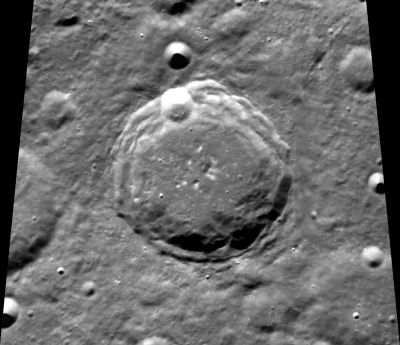
Schjellerup
Contents
Schjellerup
|
Lat: 69.7°N, Long: 157.1°E, Diam: 62 km, Depth: 4.3 km, Rükl: (farside) Upper Imbrian |
Images
LPOD Photo Gallery Lunar Orbiter Images
- Schjellerup was captured on Lunar Orbiter 4's northpole frame 92 Medium; northeast of Gamow and southeast of Seares.
- Unfortunately, there are no High-Resolution scans of this frame in the LPI's Lunar Orbiter Photo Gallery (summer 2015).
- Research: Danny Caes
Maps
(LAC zone 7D2) USGS Digital Atlas PDF
Description
Description: Wikipedia
Additional Information
- Central peak composition: A, GNTA1 (Tompkins & Pieters, 1999)
- Measures on LRO QuickMap show depth about 4.3 km - north pole craters seem deep!
- Measures on LRO QuickMap show central peak nubs about 600 m high
Nomenclature
Hans Carl Schjellerup (February 8, 1827 - November 13, 1887) was a Danish astronomer. In 1866, after the new observatory had been completed, Schjellerup assembled a catalog of red stars. He also began a study of Arabic, Chinese and other oriental languages, and used his knowledge to study old astronomic records, including those of Abd-al-Rahman al-Sûfi and Chinese records of eclipses.
LPOD Articles
Bibliography
H. C. Schjellerup in the Sourcebook Project (William R. Corliss)
- In Mysterious Universe, a handbook of astronomical anomalies (1979) :
- Page 141: The Problematical Satellite of Venus (Observatory, 1884). Note: it would be interesting to know how many of the professional astronomers were involved in the search for the (so-called) satellite of Venus (once called Neith). - DannyCaes Apr 4, 2015
