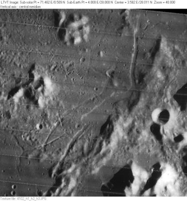
Rimae Fresnel
Contents
Rimae Fresnel
(unofficially called Fossae Fresnel)
|
Lat: 28.0°N, Long: 4.0°E, Length: 90 km, Depth: km, Rükl: 22 |
LO-IV-102H Rimae Fresnel pass through the center of this image, which includes the peaks of Mons Hadley in the lower right and the crater Santos-Dumont above them.
Images
LPOD Photo Gallery Lunar Orbiter Images Apollo Images Apollo 15 image AS15-M-1538
Maps
(LAC zone 41B4) LAC map Geologic map LM map LTO map
Description
Description: Wikipedia
Additional Information
Nomenclature
- Named after the nearby promontorium. (Promontorium Fresnel).
- Called Fossae Fresnel on Lunar Topographic Orthophotomap 41-B4.
- The original IAU nomenclature of Blagg and Müller had only one Roman-numeraled rille named after "Cape Fresnel".
- The curious duo of bowl-shaped craterlets immediately west of the Fresnel Ridge (aka Hill 305) never received an IAU-related name or letter designation. Yet, it is one of the most interesting targets for observers and photographers of small and distinct lunar regions (to test the optics of telescopes!). AS15-P-9804 is one of the ITEK-camera's panoramic images of that duo (right half of the photographic strip). Note the small central peaks in both craterlets! - DannyCaes Feb 3, 2008
LPOD Articles
- see also: Features of the Rimae Fresnel Area - Apollo Image Archive Lunar Image of the Week.
Bibliography
APOLLO OVER THE MOON; A VIEW FROM ORBIT, Chapter 6: Rimae (Part 3: Straight Rimae), Figure 218.
