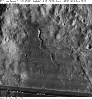
Rima Conon
Contents
Rima Conon
|
Lat: 18.6°N, Long: 2.0°E, Length: 30 km, Depth: km, Rükl: 22 |
LO-IV-102H Rima Conon zig-zags across the middle of this image. It lies in the northern fringes of Sinus Fidei. The circular crater at the mid-point of the right margin is CononW. Conon itself lies about 90 km due north of Rima Conon.
Images
LPOD Photo Gallery Lunar Orbiter Images Apollo Images
- Lunar Image of the Week, N° 70 (Sinus Fidei with Rima Conon)(oblique southward looking Apollo 17 Fairchild camera photograph).
- Apollo 17's orbital color Hasselblad camera photograph AS17-153-23581 also shows Rima Conon.- DannyCaes Sep 21, 2012
Maps
(LAC zone 41C4) LAC map Geologic map LM map LTO map
Description
Description: Wikipedia
Additional Information
Nomenclature
- Named after the nearby crater (Conon).
- Number 98 in Debra Hurwitz's Atlas and Catalog of Sinuous Rilles.
- This name was not part of the original IAU nomenclature. It was added in the System of Lunar Craters.
- A curious system of odd-shaped rilles at approximately 18° North/ 2° East (south of Rima Conon) is called the Pi Symbol by the dedicated moon observer and photographer Stefan Lammel. Investigate his interesting photograph of this region.
LPOD Articles
Bibliography
