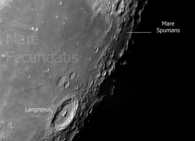
Mare Spumans
Contents
Mare Spumans
|
Lat: 1.1°N, Long: 65.1°E, Diam: 139 km, Depth: km, Rükl: 38 |
Images
LPOD Photo Gallery Lunar Orbiter Images Apollo Images
- WARNING: the first two Apollo photographs in the LPI's list of Mare Spumans (AS10-27-3911, 3912) show Lacus Solitudinis, Mare Australe, and Humboldt, and CERTAINLY NOT Mare Spumans!- DannyCaes Nov 17, 2012
- Orbital Hasselblad frames AS15-88-11959 and AS15-88-11960 show Apollo 15's CSM Endeavour over the southern part of Mare Spumans (the dark area near the upper right corner and right margin of the photographs). Looking southeastward. See also LAC 80 in Ben Bussey's and Paul Spudis's Clementine Atlas of the Moon.
- Apollo 16's oblique northward looking Fairchild camera frame AS16-M-0795 shows Mare Spumans slightly rightward of centre. Frame AS16-M-1359 shows it at centre.
- Apollo 17's oblique southward looking Fairchild camera frame AS17-M-2381 shows Mare Spumans at centre.
- Research orbital Apollo 15, Apollo 16, and Apollo 17 photography: Danny Caes
Maps
(LAC zone 62C3) LAC map Geologic map LM map LTO map
Description
Description: Wikipedia
Additional Information
- Combined Undarum-Spumans mare area of 55,000 km^2 according to measurements by Jim Whitford-Stark.
Nomenclature
- "Foaming Sea".
- Named by Franz [Whitaker: Mapping and Naming the Moon, p 225].
- Erroneously printed as MARE SPURMANS (with "R") on page 17 (chart 2) in the 21st Century Atlas of the Moon (2012).- DannyCaes Jan 23, 2013
LPOD Articles
Bibliography
A Portfolio of Lunar Drawings (Harold Hill), pages 24, 25.
