Lagrange
Contents
Lagrange
| Lat: 32.3°S, Long: 72.8°W, Diam: 225 km, Depth: 2.4 km, Rükl: 61 |
Table of Contents
[#Lagrange Lagrange]
[#Lagrange-Images Images]
[#Lagrange-Maps Maps]
[#Lagrange-Description Description]
[#Lagrange-Description: Elger Description: Elger]
[#Lagrange-Description: Wikipedia Description: Wikipedia]
[#Lagrange-Additional Information Additional Information]
[#Lagrange-Nomenclature Nomenclature]
[#Lagrange-LPOD Articles LPOD Articles]
[#Lagrange-Bibliography Bibliography]

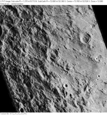
LO-IV-172H This area of the Moon is thickly blanketed with ejecta from nearby [/Mare%20Orientale Mare Orientale] making large craters difficult to recognize unless the Sun is very low. Lagrange is in the center of this view with its IAU position and diameter represented by the large circle. The actual depression seems considerably smaller and somewhat displaced to the southeast. On the west, the second largest circle represents 130-km diameter Lagrange R, which partially overlays Lagrange. In the lower right corner, the IAU circle marks the rim of 134-km [/Piazzi Piazzi].
Images
LPOD Photo Gallery Lunar Orbiter Images
The Hi-Res scan of Lunar Orbiter 4's photograph LOIV-160-h3 shows Concentric Crater Lagrange T very well! (leftward of the frame's centre).
Research: Danny Caes
Maps
([/LAC%20zone LAC zone] 109B1) USGS Digital Atlas PDF
Description
Description: Elger
([/IAU%20Directions IAU Directions]) LAGRANGE.--A larger but similar formation, 100 miles in diameter, associated with [/Piazzi Piazzi] on the N.W., with a complex terraced border, including peaks of 9,000 feet, a bright crater on the E., and a ring-plain on the N.E. The inner slope of the W. wall is a fine object at sunrise, when libration is favourable. The floor is dark and devoid of detail.
Description: Wikipedia
Additional Information
- Depth data from [/Kurt%20Fisher%20crater%20depths Kurt Fisher database]
- Cherrington, 1969: 2.4 km
- Lagrange T concentric crater.
- In C.A.Wood's list of 1978 there seems to be two different locations of this Concentric Crater. One is Lagrange T itself (number 40), and the other is mentioned as "near Lagrange T" (number 39). Who's who?
Nomenclature
- Joseph Louis; Italian mathematician (1736-1813).
- According to [/Whitaker Whitaker] (p. 220), this name was introduced by [/M%C3%A4dler Mädler].
- Crater Lagrange B was called Fresa by Hugh Percy Wilkins and Patrick Moore, but the I.A.U. did not accept that name.
- Fresa was an Italian astronomer (Alfonso Fresa?).
LPOD Articles
Bumpy, Lumpy, and Where? (see this LPOD's discussion)
Bibliography
Lagrange B ("Fresa"): [/Wilkins%20and%20Moore THE MOON] by H.P.Wilkins and P.Moore.
This page has been edited 1 times. The last modification was made by - tychocrater tychocrater on Jun 13, 2009 3:24 pm - afx3u2