Tralles
Contents
[hide]Tralles
|
Lat: 28.4°N, Long: 52.8°E, Diam: 43 km, Depth: 3.04 km, Rükl: 26 |
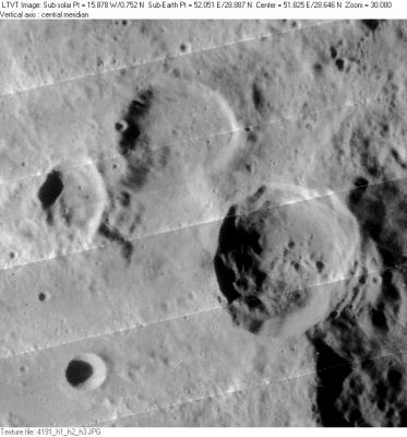
LO-IV-191H 30-km Debes is the uppermost crater in this grouping, with 43-km Tralles to the right of center. Between them, below Debes, is 33-km Debes A, and to its left, the polygonal 19-km Debes B. The 11-km circular crater in the lower left is Tralles B. The rugged inner wall of the west rim of 125-km Cleomedes looms on the far right.
Images
LPOD Photo Gallery Lunar Orbiter Images Apollo Images
Maps
(LAC zone 44A1) LAC map Geologic map
Description
Description: Elger
(IAU Directions) TRALLES.--A large irregular crater, one of the deepest on the visible surface of the moon, situated on the N.W. wall of Cleomedes. There is a crater on its N. wall, and, according to Schmidt, some ridges and three closely associated craters on the floor.
Description: Wikipedia
Additional Information
- Depth data from Kurt Fisher database
Westfall, 2000: 3.04 km
Viscardy, 1985: 3.35 km - Included in ALPO list of bright ray craters
Nomenclature
- Johann Georg Tralles (October 15, 1763 - November 19, 1822) was a German mathematician and physicist. In 1798 he served as the Swiss representative to the French metric convocation, and was a member of its committee on weights and measures. He was the inventor of the alcoholmeter, a device for measuring the amount of alcohol in a liquid.
- According to Whitaker (p. 219), this name was introduced by Mädler.
LPOD Articles
Bibliography
