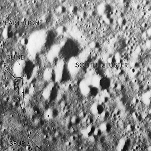
South Cluster
Contents
South Cluster (Apollo 15 site craterlet-cluster name)
|
Lat: 26.0°N, Long: 3.7°E, Diam: 2 km, Depth: km, Rükl: 22 |
Apollo 15 Site Traverses Chart
Images
LPOD Photo Gallery Lunar Orbiter Images Apollo Images
See also:
Map of all the named craters and craterlets in the neighborhood of Apollo 15's landingsite, chosen by Joseph Allen and the crew Note the named craters in the South Cluster! - DannyCaes Jan 21, 2008
Maps
(LAC zone 41B4) LAC map Geologic map LM map LTO map
Description
South Cluster is an irregular cluster of shallow depressions on the Plain north of Mount Hadley Delta.
It is perhaps possible to observe this cluster through very powerful telescopes, during excellent seeing conditions. Maybe digital photography (webcam attached to the telescope) could catch that cluster (pre-sunset conditions; low western sun to show the shadowed inner slopes of the cluster's shallow depressions).
Description: Wikipedia
(no Wikipedia page for Apollo 15's South Cluster).
Additional Information
Nomenclature
- Astronaut-named feature, Apollo 15 site.
  - Several craters and depressions in the South Cluster were individually named by NASA's Joe Allen and Apollo 15's crew. These names are: Arrowhead, Blinky, Crescent, Dune, Fifty One, Kimbal, Lightning, Pitane, and a crater which is located slightly offset near the South Cluster's southeastern rim, hence the name Offset.
LPOD Articles
Bibliography
Kenneth F. Weaver: Apollo 15 explores the mountains of the moon (National Geographic, February 1972).
  David M. Harland: EXPLORING THE MOON; The Apollo Expeditions.
  Eric M. Jones: APOLLO LUNAR SURFACE JOURNAL (ALSJ).
