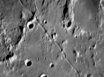
Rima Ariadaeus
Contents
Rima Ariadaeus
|
Lat: 6.4°N, Long: 14.0°E, Length: 250 km, Depth: 0.48 km, Rükl: 34 |
Images
LPOD Photo Gallery Lunar Orbiter Images Apollo Images
Maps
(LAC zone 60D1) LAC map Geologic map LM map AIC map
Description
Description: Wikipedia
Additional Information
Depth data from Kurt Fisher database
- Viscardy, 1985: 0.48 km
Nomenclature
- Named from nearby crater. (Ariadaeus)
- Rima Ariadaeus (or an area near Rima Ariadaeus) was once known as Potamos. This was one of Felix Chemla Lamech's new names, but the I.A.U. did not accept that name.
- Research Lamech's "Potamos": Ewen A. Whitaker and Danny Caes (August 2003, mail correspondence).
LPOD Articles
Down the Rille
Great Graben
Edgy
Lunar 100
L29: "Long, linear graben."
Bibliography
- Wood, C.A. 10/2005. The Straight Story on Linear Rilles. S&T 110(4):62-63
- Mapping and Naming the Moon; a history of lunar cartography and nomenclature (Ewen A. Whitaker).
- APOLLO OVER THE MOON; A VIEW FROM ORBIT, Chapter 6: Rimae (Part 3: Straight Rimae), Figure 217.
- A Portfolio of Lunar Drawings (Harold Hill), pages 4, 5.
