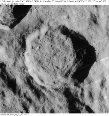
Shaler
Contents
Shaler (of the pair Wright-Shaler)
|
Lat: 32.9°S, Long: 85.2°W, Diam: 48 km, Depth: 3.31 km, [/R%C3%BCkl%2061 Rükl: 61] |
Table of Contents
[#Shaler (of the pair Wright-Shaler) Shaler (of the pair Wright-Shaler)]
[#Shaler (of the pair Wright-Shaler)-Images Images]
[#Shaler (of the pair Wright-Shaler)-Maps Maps]
[#Shaler (of the pair Wright-Shaler)-Description Description]
[#Shaler (of the pair Wright-Shaler)-Description: Wikipedia Description: Wikipedia]
[#Shaler (of the pair Wright-Shaler)-Additional Information Additional Information]
[#Shaler (of the pair Wright-Shaler)-Nomenclature Nomenclature]
[#Shaler (of the pair Wright-Shaler)-LPOD Articles LPOD Articles]
[#Shaler (of the pair Wright-Shaler)-Bibliography Bibliography]

LO-IV-186H
Shaler in the image's central section, its companion Wright in the upper left corner.
Images
LPOD Photo Gallery Lunar Orbiter Images
Maps
([/LAC%20zone LAC zone] 109A1) USGS Digital Atlas PDF
Description
Description: Wikipedia
Additional Information
Depth data from [/Kurt%20Fisher%20crater%20depths Kurt Fisher database]
- Westfall, 2000: 3.31 km
Nomenclature
- Nathaniel Southgate Shaler (1841-1906) was an American geologist and paleontologist who wrote in 1903 one of the first geologic studies of the Moon: A Comparison of the Features of the Earth and the Moon.
- Name given by Arthur and Whitaker in [/Rectified%20Lunar%20Atlas Rectified Lunar Atlas] (1963) and approved by IAU in 1964 ([/Whitaker Whitaker], 1999, p234).
LPOD Articles
Bibliography
- On-line/downloadable copy of Shaler's book.
This page has been edited 1 times. The last modification was made by - tychocrater tychocrater on Jun 13, 2009 3:24 pm - afx3u2