Macrobius
Contents
Macrobius
|
Lat: 21.3°N, Long: 46.0°E, Diam: 64 km, Depth: 4.05 km, Rükl: 26, [/Stratigraphy Lower Imbrian] |
Table of Contents

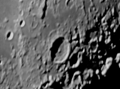
Peter Lloyd The crater Macrobius imaged on day 17.8 of the lunar cycle so the Sun was low in the western sky on this part of the Moon.
Images
LPOD Photo Gallery Lunar Orbiter Images Apollo Images
Apollo 17-M296
Maps
([/LAC%20zone LAC zone] 43C2) LAC map Geologic map LTO map
Description
Description: Elger
([/IAU%20Directions IAU Directions]) MACROBIUS.--This, with a companion ring on the E., is a very beautiful object under a low sun. It is 42 miles in diameter, and is encircled by a bright, regular, but complex border, some 13,000 feet in height above the floor. Its crest is broken on the W. by a large brilliant crater, and its continuity is interrupted on the N. by a formation resembling a large double crater, which is associated with a number of low rounded banks and ridges extending some distance towards the N.E., and breaking the continuity of the glacis. The E. wall is much terraced, and on the N.E. includes a row of prominent depressions, well seen when the interior is about half illuminated under a rising sun. The central mountain is of the compound type, but not at all prominent. The companion ring, Macrobius C, is terraced internally on the E., and the continuity of its N. border broken by two depressions. There is a rill-valley between its N.W. side and Macrobius.
Description: Wikipedia
Additional Information
- Depth data from [/Kurt%20Fisher%20crater%20depths Kurt Fisher database]
- Pike, 1976: 4.05 km
- Westfall, 2000: 4.05 km
- Viscardy, 1985: 3.7 km
- Cherrington, 1969: 3.59 km
- Central peak height
- [/Sekiguchi%2C%201972 Sekiguchi, 1972]: 1.6 km. A large hill on the NW of the central peak rises 0.8 km - fatastronomer fatastronomer
- Macrobius A (Carmichael) and B (Hill) are thermal anomaly craters, implying youthful ages; the north wall of Macrobius itself also is an anomaly, due to the exposure of fresh boulders - [/Moore%20et%20al%2C%201980 Moore et al, 1980]
- Slightly westward of Macrobius (between Macrobius, Esclangon, and Hill) is a craterlet with an unusual winglike ("butterfly"-like) ejectablanket. This craterlet is described and depicted in NASA SP-362, APOLLO OVER THE MOON, A VIEW FROM ORBIT, Chapter 5: Craters (Part 2), Figure 113. AS15-87-11700 is the orbital Hasselblad of it, which is included in Kipp Teague's Project Apollo Archive. - DannyCaes DannyCaes Dec 27, 2007
Nomenclature
Ambrosius Aurelius Theodosius; Roman writer (unkn-fl. c. 410).
LPOD Articles
Bibliography
This page has been edited 1 times. The last modification was made by - tychocrater tychocrater on Jun 13, 2009 3:24 pm - afx4