Karima
Contents
Karima
| Lat: 25.9°S, Long: 103.0°E, Diam: 3 km, Depth: km, Rükl: (farside) |
Table of Contents
[#Karima Karima]
[#Karima-Images Images]
[#Karima-Maps Maps]
[#Karima-Description Description]
[#Karima-Description: Wikipedia Description: Wikipedia]
[#Karima-Additional Information Additional Information]
[#Karima-Nomenclature Nomenclature]
[#Karima-LPOD Articles LPOD Articles]
[#Karima-Bibliography Bibliography]

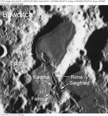
AS15-M-2358 The area shown here is on the northwest shore of [/Lacus%20Solitudinis Lacus Solitudinis], between the craters [/Titius Titius] and [/Perel%27man Perel'man].
In addition to the the dark-floored [/Bowditch Bowditch], the labels indicate several IAU-approved [/minor%20feature minor feature] names: [/Edith Edith], [/Bawa Bawa], [/Karima Karima], [/Fairouz Fairouz] and [/Rima%20Siegfried Rima Siegfried]. [/Bawa Bawa] is a pit along the west wall of [/Bowditch Bowditch]. It is completely in shadow in this view.
Images
LPOD Photo Gallery Lunar Orbiter Images Apollo Images
Maps
([/LAC%20zone LAC zone] 100C1) LTO map Topophotomap
Description
Description: Wikipedia
Additional Information
Nomenclature
Arabic female name.
- According to [/NASA%20RP-1097 NASA RP-1097], "Karima" is a [/Minor%20Feature Minor Feature] whose name was originally intended only for use in connection with Topophotomap 100C1/S1(on which it is plotted).
LPOD Articles
Bibliography
This page has been edited 1 times. The last modification was made by - tychocrater tychocrater on Jun 13, 2009 3:24 pm - afx3u2