Mare Fecunditatis
Contents
Fecunditatis Basin
(unofficial name; IAU feature name for central 909 km of mare: Mare Fecunditatis, formerly Mare Foecunditatis )
|
Lat: 7.8°S, Long: 51.3°E, Main ring diam: 690 km, Basin depth: 1.84 km, [/R%C3%BCkl%2048 Rükl: 48] |


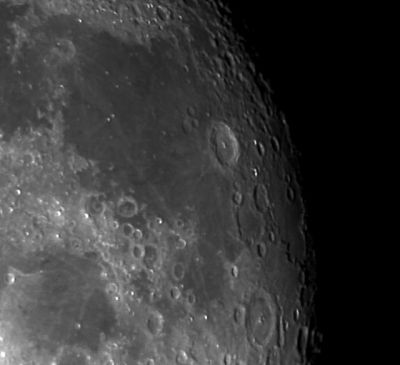
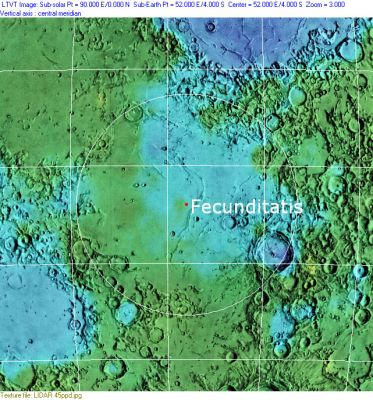
Left: Eric Soucy, Right: Clementine, Clementine LIDAR Altimeter texture from PDS Map-a-Planet remapped to north-up aerial view by LTVT. The dot is the center position and the white circle the main ring position from Chuck Wood's Impact Basin Database. Grid spacing = 10 degrees.
Table of Contents
[#Fecunditatis Basin Fecunditatis Basin]
[#Fecunditatis Basin-Images Images]
[#Fecunditatis Basin-Maps Maps]
[#Fecunditatis Basin-Basin Classification Basin Classification]
[#Fecunditatis Basin-Description Description]
[#Fecunditatis Basin-Description: Wikipedia Description: Wikipedia]
[#Fecunditatis Basin-Additional Information Additional Information]
[#Fecunditatis Basin-Nomenclature Nomenclature]
[#Fecunditatis Basin-LPOD Articles LPOD Articles]
[#Fecunditatis Basin-LROC Articles LROC Articles]
[#Fecunditatis Basin-Bibliography Bibliography]
Images
LPOD Photo Gallery Lunar Orbiter Images Apollo Images
Maps
([/LAC%20zone LAC zone] 80A4) LAC map Geologic map LTO map
[/Lunar%20Basins Basin Classification]
(description of terms and most numeric basin data from Wood, C.A. (2004) Impact Basin Database)
| Certainty of Existence |
USGS Age |
Wilhelms Age Group |
Ring Diameters |
Mare Thickness |
Mascon |
| Uncertain |
Pre-Nectarian |
3 |
690, 990 km |
No |
Description
Description: Wikipedia
Additional Information
- 1970, Sept.: Luna 16 - first automated sample return, from Mare Fecunditatis
- Mare area of 220,000 km^2 according to measurements by Jim Whitford-Stark.
Nomenclature
- Called Mare Langrenianum by the father of selenography Michel Florent Van Langren (aka Langrenus).
- Called Mare Caspium by Johann Hewelcke (aka Hevelius).
- Called Mare Fecunditatis (or Mare Foecunditatis) by Giovanni Baptista Riccioli.
- The IAU feature name (Mare Fecunditatis) means "Sea of Fecundity" (or Fertility / Fruitfulness).
- The impact basin is named after the mare.
- The craters Taruntius G (Anville), Taruntius H, Taruntius K, and Taruntius P (all of them in the north-northwestern part of Mare Fecunditatis) were frequently photographed during several missions of the Apollo program. All four craters together look like some sort of "Constellation", or rather a "Constellation of Four" (thus nicknamed by Danny Caes, who's investigating all orbital Apollo photographs of these four craters, see page Anville).
LPOD Articles
Fecund Questions A Shallow Sea of Lava North-western surface Basin and lava Mare ridges Rays
LROC Articles
Mare Pit Topography! (Skylight in Mare Fecunditatis, unofficially called the Central Mare Fecunditatis Pit).
Bibliography
Rajmon, D & P Spudis (2000) Geology and Stratigraphy of Mare Fecunditatis. Lunar & Planetary Science 31, 1913.
This page has been edited 1 times. The last modification was made by - tychocrater tychocrater on Jun 13, 2009 3:24 pm - afx3u2