Rimae Palmieri
Contents
Rimae Palmieri
|
Lat: 28.0°S, Long: 47.0°W, Length: 150 km, Depth: km, Rükl 51 |
Table of Contents
[#Rimae Palmieri Rimae Palmieri]
[#Rimae Palmieri-Images Images]
[#Rimae Palmieri-Maps Maps]
[#Rimae Palmieri-Description Description]
[#Rimae Palmieri-Description: Wikipedia Description: Wikipedia]
[#Rimae Palmieri-Additional Information Additional Information]
[#Rimae Palmieri-Nomenclature Nomenclature]
[#Rimae Palmieri-LPOD Articles LPOD Articles]
[#Rimae Palmieri-Bibliography Bibliography]

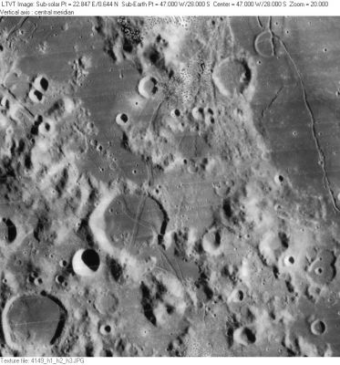
LO-IV-149H Rimae Palmieri extend out from the prominent "X" pattern in the center of Palmieri. The rilles on the right are part of a separate system (Rimae Doppelmayer).
Images
LPOD Photo Gallery Lunar Orbiter Images Apollo Images
Maps
(LAC zone 93D4) LAC map Geologic map
Description
Description: Wikipedia
- Two Roman-numeralled rilles associated with Palmieri were part of the original IAU nomenclature of Blagg and Müller. Exactly when the name in its present form was adopted is unclear. - JimMosher JimMosher
Additional Information
What is very curious about the crossing of both rilles on the floor of Palmieri is the rectangle-shaped depression at the very centre of the "X". Which one of the two rilles was first? Or did they appear simultaneously? Are there much more of these rectangle-shaped depressions on the moon? (created by rille crossings).
Nomenclature
Named from nearby crater. (Palmieri)
LPOD Articles
Bibliography
This page has been edited 1 times. The last modification was made by - tychocrater tychocrater on Jun 13, 2009 3:24 pm - afx3u2