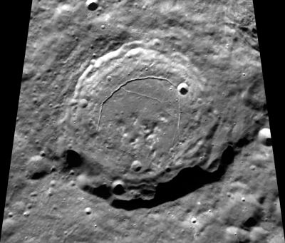
Karpinskiy
Contents
Karpinskiy - and Rimae Karpinskiy
|
Lat: 73.3°N, Long: 166.3°E, Diam: 92 km, Depth: 2.1 km, Rükl: (farside), Lower Imbrian |
Table of Contents
[#Karpinskiy - and Rimae Karpinskiy Karpinskiy - and Rimae Karpinskiy]
[#Karpinskiy - and Rimae Karpinskiy-Images Images]
[#Karpinskiy - and Rimae Karpinskiy-Maps Maps]
[#Karpinskiy - and Rimae Karpinskiy-Description Description]
[#Karpinskiy - and Rimae Karpinskiy-Description: Wikipedia Description: Wikipedia]
[#Karpinskiy - and Rimae Karpinskiy-Additional Information Additional Information]
[#Karpinskiy - and Rimae Karpinskiy-Nomenclature Nomenclature]
[#Karpinskiy - and Rimae Karpinskiy-LPOD Articles LPOD Articles]
[#Karpinskiy - and Rimae Karpinskiy-Bibliography Bibliography]

Clementine
The system of pronounced rilles on the floor of Karpinskiy doesn't seem to have an official name. Let's call it (or them) Rimae Karpinskiy.
Images
LPOD Photo Gallery Lunar Orbiter Images
Maps
(LAC zone 7A3) USGS Digital Atlas PDF
Description
Description: Wikipedia
Additional Information
- TSI = 25, CPI = 20, FI = 25; MI =70 Smith and Hartnell, 1973 (CAW update)
- Floor-fractured crater
- Measures on LRO QuickMap show rim height very uneven, 2.1 about max depth
Nomenclature
Alexander Petrovich Karpinsky (1846 – 1936) was a Russian and Soviet geologist and mineralogist. His main research was chiefly done in the Urals, and he completed the first geological map of European Russia. He was able to preserve much scientific equipment and many invaluable records during the Russian Revolution.
Rimae Karpinskiy (an unofficial name from D.Caes for the system of pronounced rilles on the floor of Karpinskiy).
LPOD Articles
Bibliography
This page has been edited 1 times. The last modification was made by - tychocrater tychocrater on Jun 13, 2009 3:24 pm - afx3u2