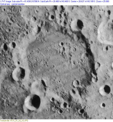
Wilhelm
Contents
Wilhelm
|
Lat: 43.4°S, Long: 20.4°W, Diam: 106 km, Depth: 3.24 km, Rükl: 64 |
Table of Contents

LO-IV-131H
Images
LPOD Photo Gallery Lunar Orbiter Images
Maps
(LAC zone 111C1) LAC map Geologic map
Description
Description: Elger
(IAU Directions) WILHELM I.--A large irregular formation, about 50 miles across, S.W. of Heinsius, with walls varying very considerably in height, rising more than 11,000 feet on the W., but only about 7,000 feet on the opposite side. The border is everywhere crowded with depressions, large and small. Three ring-plains, not less than 6 miles in diameter, stand upon the S. wall, the most easterly overlapping its shallower neighbour on the W., which projects beyond the wall on to the floor. The interior has a very rugged and uneven surface, upon the N. side of which are two very distinct craters, and a short crater-row on the E. of them. It is traversed from E. to W. by three bright streaks from Tycho, two on the N. being very prominent under a high light.
Description: Wikipedia
Additional Information
Depth data from Kurt Fisher database
- Westfall, 2000: 3.24 km
- Viscardy, 1985: 3.5 km
- Cherrington, 1969: 2.89 km
- Satellite craters Wilhelm A, B, E, K and O are on the ALPO list of banded craters
Nomenclature
- Wilhelm IV, Landgrave of Hesse; German astronomer (1532-1592).
- This name was introduced by Michel Florent Van Langren (aka Langrenus) as Wilhelmi Lantgravii (for the crater nowadays officially known as Mee). See page 200 in Ewen A. Whitaker's Mapping and Naming the Moon.
- Before this crater was officially called Wilhelm, it was known as Wolfgangi D. Neoburgi on the moonmap made by Michel Florent Van Langren (aka Langrenus).
- J.H.Schroter's Vinc. Wing (plate T. LV). This is a somewhat vaguely-defined depression at 16.4°W, 41.3°S, about 55 km in diameter, extending from the modern Wilhelm D to Heinsius M.
Vincent Wing (1619-1668) was a self-taught English astronomer known for his many publications, including the founding of an almanac continued for more than a century. Flamsteed reportedly regarded Wing's Ephemerides as the best available at the time. His most noted work was a a complete system of astronomy, Astronomia Britannica (1652, 2nd ed. 1669).
Research Jim Mosher and Ewen A. Whitaker.
LPOD Articles
Bibliography
This page has been edited 1 times. The last modification was made by - tychocrater tychocrater on Jun 13, 2009 3:24 pm - afx2u2