Chang'e-1
Contents
Chang'E-1 (CE-1)

Table of Contents
[#Chang'E-1 (CE-1) Chang'E-1 (CE-1)]
[#Chang'E-1 (CE-1)-Description Description]
[#Chang'E-1 (CE-1)-Additional Information Additional Information]
[#Chang'E-1 (CE-1)-LPOD Articles LPOD Articles]
[#Chang'E-1 (CE-1)-Bibliography Bibliography]
Description
Chinese lunar mapping satellite, launched October 24, 2007, and operated in lunar orbit from November 2007 through impact with the lunar surface on March 1, 2009. Its complement of instruments included high resolution stereo cameras, spectrometers and a laser altimeter.
Additional Information
- A very limited amount of information about Chang'E-1 is available on the English-language version of the Chinese Lunar Exploration Program website. Much more information is available on the Chinese language version.
- Scientific results seem to appear only in Chinese, in a small image gallery. With some effort it is possible to navigate through the gallery using the Google-translate version. However, the text under each image in the Chinese versions (which links to a larger photo and more detailed explanation) is not linked in the translation, so you have to keep two window open -- following the links from the Chinese page, then asking Google to translate them separately.
- A Chang'E-1 mosaic of the whole Moon has been released, but initially available only at rather low resolution (too low to read the captions). The rectangular panel in the center covers the region from -180 to +180° in longitude and +70 to -70° in Mercator projection. The two circular maps on the right show the north and south polar regions, presumably in stereographic projection.
- The full(?) Clementine-like mosaic is accessible via a Map-A-Planet-like Web GIS interface on the Chinese Academy of Sciences' National Astronomical Observatories' Moon Center site. Look for the link labeled "月球WebGIS系统". The radio buttons at the top of the left-hand panel toggle between a full-Moon Mercator(?) projection, and polar projections of the north pole and south pole. The Chinese forms of the current IAU feature names can be superimposed on the map by IAU feature-type class, as well as by features named for Chinese persons.
- Google translate may be helpful for understanding the Moon Center site, which does not seem to be available in English (look for "Moon Map").
- The full(?) Clementine-like mosaic is accessible via a Map-A-Planet-like Web GIS interface on the Chinese Academy of Sciences' National Astronomical Observatories' Moon Center site. Look for the link labeled "月球WebGIS系统". The radio buttons at the top of the left-hand panel toggle between a full-Moon Mercator(?) projection, and polar projections of the north pole and south pole. The Chinese forms of the current IAU feature names can be superimposed on the map by IAU feature-type class, as well as by features named for Chinese persons.
- Impact site.
- Microwave images


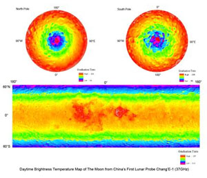
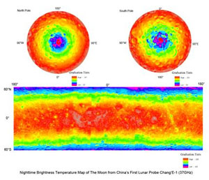
False colour images of the microwave (global) Moon. The left image above shows a daytime brightness temperature map at 37 GHz microwave frequency, while the right image is a nighttime brightness temperature global map again at 37 GHz microwave frequency. Both images were taken by the Chang'E-1 spacecraft as it orbited the Moon between 2007-09, and sent back as data by an instrument onboard called the Lunar Microwave Radiometer (MRM). The MRM scanned the surface and deeper sub-surface layers using four frequency ranges (3, 7.8, 19.35, and 37 GHz.) in all; each capable of revealing different aspects about the moon's external and internal temperatures. Presented at the European Planetary Science Congress (EPSC) in Rome (Sept., 2010).- JohnMoore2 JohnMoore2
Credit: Europlanet Media Centre - According to the article by Ouyang Ziyuan et al (2010), the Chang'E-1 mission ended with a controlled impact at 52.36°E, 1.50°S (in Mare Fecunditatis) at "16:13:10 LT" (08:13:10 UTC) on March 1, 2009.
LPOD Articles
Bibliography
- Ling, Z. C. et al (2011). Mapping Titanium Abundance Using Chang’E-1 IIM Data – 42nd LPSC Conference (Mar), 2011.
- Wu, Y. Z. et al (2011). Global Distribution of FeO and TiO2 as Derived from Chang’E-1 IIM data – 42nd LPSC Conference (Mar), 2011.
- Zheng, Y-C. et al. 2010. Global Brightness Temperature of the Moon: Result from Chang’E-1 Microwave Radiometer - EPSC Abstracts, Vol. 5, EPSC2010-224, 2010 - European Planetary Science Congress, September 2010.
- Wikipedia page
- Ouyang Ziyuan et al "Chang’E-1 Lunar Mission: An Overview and Primary Science Results." Chin. J. Space Sci. Vol. 30(5) pp. 392–403. PDF.
This page has been edited 1 times. The last modification was made by - tychocrater tychocrater on Jun 13, 2009 3:24 pm - mgx2