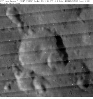
Borda
Contents
Borda
|
Lat: 25.1°S, Long: 46.6°E, Diam: 44 km, Depth: 3.64 km, Rükl: 59 |
Table of Contents

LO-IV-065H
Images
LPOD Photo Gallery Lunar Orbiter Images Apollo Images
Maps
(LAC zone 97C2) LAC map Geologic map
Description
Description: Elger
(IAU Directions) BORDA.--A ring-plain about 25 miles in diameter, S.S.E. of Santbech, with a rampart low on the N. and S., but elsewhere of considerable height, and a very conspicuous central mountain. A wide deep valley flanked by lofty mountains extends from the N. wall for many miles towards the N.E. It is an especially noteworthy object when the E. wall of Santbech is on the evening terminator, as its somewhat winding course, indicated by the bright summit-ridges of the bordering mountains, can be followed some hours before either the interior of the valley or the region between it and Santbech are in sunlight. Among the mountains E. of Borda there is a peak more than 11,000 feet in height.
Description: Wikipedia
Additional Information
- Depth data from Kurt Fisher database
- Westfall, 2000: 3.64 km
- Viscardy, 1985: 2.9 km
- Central peak height
- Sekiguchi, 1972: 2.0 km, 1.5 km tall oblong peak (aligned N-S) in southern part of floor - fatastronomer fatastronomer
Nomenclature
Jean Charles de; French astronomer (1733-1799).
- This name was introduced by Mädler (Whitaker, p. 219).
- Borda Delta (the central peak of Borda) (see Chart 86 in the Times Atlas of the Moon). Borda Delta is not mentioned on chart SLC A6 from the System of Lunar Craters, 1966.
- The name Borda was not included on the corresponding LAC map (LAC 97) in the Clementine Atlas of the Moon.- DannyCaes DannyCaes Aug 15, 2010
LPOD Articles
Uninspiring, but an Active History
Bibliography
This page has been edited 1 times. The last modification was made by - tychocrater tychocrater on Jun 13, 2009 3:24 pm - afx3u2