Lee
Contents
Lee
| Lat: 30.7°S, Long: 40.7°W, Diam: 41 km, Depth: 1.34 km, Rükl: 62 |
Table of Contents

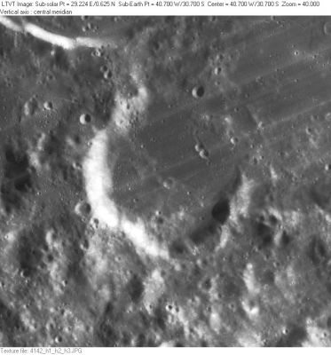
LO-IV-142H Lee is in the center. A piece of the south rim of [/Doppelmayer Doppelmayer] is visible at the top. The shallow 8-km just outside Lee’s southwest rim is Lee A and a little irregular 4-km pit in the upper left, near the margin at about 10 o’clock from the center of Lee is Lee T. The entire upper right quadrant of this frame is regarded as part of Lee M, a 47-km ruined enclosure of the southwest floor of [/Mare%20Humorum Mare Humorum] between [/Doppelmayer Doppelmayer] and [/Vitello Vitello].
Images
LPOD Photo Gallery Lunar Orbiter Images
Maps
([/LAC%20zone LAC zone] 93D3) LAC map Geologic map
Description
Description: Elger
([/IAU%20Directions IAU Directions]) LEE.--An incomplete walled-plain, about 28 miles in diameter, on the S. side of the [/Mare%20Humorum Mare Humorum], W. of [/Vitello Vitello], from which it is separated by another partial enclosure, with a striking valley, not shown in the published maps, running round its E. side. If viewed when its W. wall is on the morning terminator, some isolated relics of the wrecked N.E. wall of Lee are prominent, in the shape of a number of attenuated bright elevations separated by gaps. Within are three or four conspicuous hills.
Description: Wikipedia
Additional Information
Depth data from [/Kurt%20Fisher%20crater%20depths Kurt Fisher database]
- Arthur, 1974: 1.34 km
- Westfall, 2000: 1.34 km
- Viscardy, 1985: 1.34 km
- Satellite crater Lee E is on the [/ALPO%20list%20of%20banded%20craters ALPO list of banded craters]
Nomenclature
John Lee; British astronomer, humanitarian (1783-1866). According to [/Whitaker Whitaker], Lee, along with his younger friend William R. [/Birt Birt], produced an outline map of the Moon introducing 85 new names, many of which are in use today. - JimMosher JimMosher
- According to [/Whitaker Whitaker] (p. 221), this name was introduced by [/Birt Birt] and [/Lee Lee] (one assumes by Birt). - JimMosher JimMosher
- Not to be confused with Apollo 17's Lee scarp at the Taurus-Littrow Valley! "Robert E. Lee was a man of immense ability and honor who, in his dedication to friends and tradition, found personal compromise with the future impossible. Such a national tragedy should represent a lesson we can safely learn only once." (source: APOLLO LUNAR SURFACE JOURNAL, Eric M. Jones).
- Perhaps it's interesting to know something about the astronomer T. A. Lee who's mentioned at the lower part of page 1568 in Volume 3 of Bu'rnham's Celestial Handbook. - DannyCaes DannyCaes May 15, 2015
The short list of three... (a lunar curiosity)
If... a certain crater on the moon would be known as See (Thomas Jefferson Jackson See) it could join Lee and Mee. - DannyCaes DannyCaes May 14, 2015
Van Langren's Quaresini
The hill Lee Eta seems to have been called Quaresini by Van Langren (see page 196 in E.A.Whitaker's Mapping and Naming the Moon). If this name was officially recognized by the I.A.U., it could have joined the name Quetelet in the ultra-short Q list (two official names!) (a lot).- DannyCaes DannyCaes Jan 23, 2016
LPOD Articles
Bibliography
This page has been edited 1 times. The last modification was made by - tychocrater tychocrater on Jun 13, 2009 3:24 pm - afx3u2