Difference between revisions of "North Complex"
(Created page with "<div id="content_view" class="wiki" style="display: block"> =North Complex (Apollo 15 site formation name)= {| class="wiki_table" | Lat: 26.2°N, Long: 3.6°E, Diam: 2 km,...") |
|||
| Line 3: | Line 3: | ||
{| class="wiki_table" | {| class="wiki_table" | ||
| | | | ||
| − | Lat: 26.2°N, Long: 3.6°E, Diam: 2 km, Depth: km, [ | + | Lat: 26.2°N, Long: 3.6°E, Diam: 2 km, Depth: km, [[R%C3%BCkl%2022|Rükl: 22]]<br /> |
|} | |} | ||
<div id="toc"> | <div id="toc"> | ||
| Line 17: | Line 17: | ||
<br /> | <br /> | ||
==Maps== | ==Maps== | ||
| − | ''([ | + | ''([[LAC%20zone|LAC zone]] 41B4)'' [http://www.lpi.usra.edu/resources/mapcatalog/LAC/lac41/ LAC map] [http://www.lpi.usra.edu/resources/mapcatalog/usgs/I463/ Geologic map] [http://www.lpi.usra.edu/resources/mapcatalog/LM/lm41/ LM map] [http://www.lpi.usra.edu/resources/mapcatalog/LTO/lto41b4_2/ LTO map] [http://www.lpi.usra.edu/resources/mapcatalog/topophoto/41B4S1/ Topophotomap]<br /> <br /> |
==Description== | ==Description== | ||
<br /> | <br /> | ||
| Line 23: | Line 23: | ||
[https://en.wikipedia.org/wiki/North_Complex North Complex] (correct link)<br /> <br /> | [https://en.wikipedia.org/wiki/North_Complex North Complex] (correct link)<br /> <br /> | ||
==Additional Information== | ==Additional Information== | ||
| − | The [ | + | The [[Landing%20Site%20Name|Landing Site Name]] "North Complex" is plotted on [http://www.lpi.usra.edu/resources/mapcatalog/topophoto/41B4S1/ Topophotomap 41B4/S1] .<br /> <br /> |
==Nomenclature== | ==Nomenclature== | ||
| − | Astronaut-named feature, [ | + | Astronaut-named feature, [[Apollo%2015%20site|Apollo 15 site]].<br /> Several craters, depressions, and a hill in the '''North Complex''' were individually named by NASA's Joe Allen and Apollo 15's crew:<br /> |
* '''Chain''' | * '''Chain''' | ||
Revision as of 15:06, 15 April 2018
Contents
North Complex (Apollo 15 site formation name)
|
Lat: 26.2°N, Long: 3.6°E, Diam: 2 km, Depth: km, Rükl: 22 |
Table of Contents
[#North Complex (Apollo 15 site formation name) North Complex (Apollo 15 site formation name)]
[#North Complex (Apollo 15 site formation name)-Images Images]
[#North Complex (Apollo 15 site formation name)-Maps Maps]
[#North Complex (Apollo 15 site formation name)-Description Description]
[#North Complex (Apollo 15 site formation name)-Description: Wikipedia Description: Wikipedia]
[#North Complex (Apollo 15 site formation name)-Additional Information Additional Information]
[#North Complex (Apollo 15 site formation name)-Nomenclature Nomenclature]
[#North Complex (Apollo 15 site formation name)-LPOD Articles LPOD Articles]
[#North Complex (Apollo 15 site formation name)-Bibliography Bibliography]

Apollo 15 Site Traverses Chart
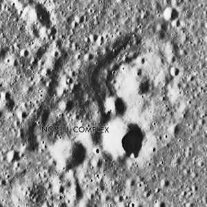
The largest crater in the North Complex is called Pluton. This is one of the unofficially named (or NASA-named) craters near Apollo landing sites (such as Apollo 15's site) which could be observed and photographed through terrestrial telescopes. See LPOD More Res.
Images
LPOD Photo Gallery Lunar Orbiter Images Apollo Images
- In Apollo 15's Hasselblad frame AS15-85-11509, which shows the distant North Complex as it was photographed from Station 6' on the slope of Mons Hadley Delta, the bright spot above and slightly to the left of the first fiducial above the center one is the area brightened by LM Falcons Descent Engine. Source: ALSJ (Apollo Lunar Surface Journal, Eric M. Jones).
- Two 500-mm Hasselblad frames (AS15-84-11324 and 11325) show LM Falcon, seen from Station 6. Part of the North Complex is noticeable in the background (note the large boulders!). See also page 125 in David M. Harland's Exploring the Moon (1999).
- Pluton, the largest crater in the North Complex, is an excellent test-target for today's dedicated Hi-Res photographers of the moon. - DannyCaes DannyCaes Jan 21, 2008
- See also:
- Map of all the named craters and craterlets at the North Complex, chosen by Joseph Allen and Apollo 15's crew
Maps
(LAC zone 41B4) LAC map Geologic map LM map LTO map Topophotomap
Description
Description: Wikipedia
North Complex (correct link)
Additional Information
The Landing Site Name "North Complex" is plotted on Topophotomap 41B4/S1 .
Nomenclature
Astronaut-named feature, Apollo 15 site.
  Several craters, depressions, and a hill in the North Complex were individually named by NASA's Joe Allen and Apollo 15's crew:
- Chain
- Dome
- Eaglecrest
- Icarus
- Link
- Pluton (the largest crater of the cluster)
- Schaber Hill
- Slide
Partially included are:
- Misty Doublet
- Rio
LPOD Articles
Bibliography
Kenneth F. Weaver: Apollo 15 explores the mountains of the moon (National Geographic, February 1972).
  David M. Harland: EXPLORING THE MOON; The Apollo Expeditions.
  Eric M. Jones: APOLLO LUNAR SURFACE JOURNAL (ALSJ).
This page has been edited 1 times. The last modification was made by - tychocrater tychocrater on Jun 13, 2009 3:24 pm - afx3u2