Difference between revisions of "Doublet"
| Line 3: | Line 3: | ||
{| class="wiki_table" | {| class="wiki_table" | ||
| colspan="2" | | | colspan="2" | | ||
| − | Lat: 3.7°S, Long: 17.5°W, Diam: 0.4 km, Depth: km, [ | + | Lat: 3.7°S, Long: 17.5°W, Diam: 0.4 km, Depth: km, [[R%C3%BCkl%2042|Rükl: 42]]<br /> |
|} | |} | ||
<div id="toc"> | <div id="toc"> | ||
| Line 18: | Line 18: | ||
[http://www.lpod.org/coppermine/thumbnails.php?album=search&type=full&search=Doublet LPOD Photo Gallery] [http://www.lpi.usra.edu/resources/lunar_orbiter/bin/srch_nam.shtml?Doublet%7C0 Lunar Orbiter Images] [http://www.lpi.usra.edu/resources/apollo/search/feature/?feature=Doublet Apollo Images]<br /> <br /> | [http://www.lpod.org/coppermine/thumbnails.php?album=search&type=full&search=Doublet LPOD Photo Gallery] [http://www.lpi.usra.edu/resources/lunar_orbiter/bin/srch_nam.shtml?Doublet%7C0 Lunar Orbiter Images] [http://www.lpi.usra.edu/resources/apollo/search/feature/?feature=Doublet Apollo Images]<br /> <br /> | ||
==Maps== | ==Maps== | ||
| − | ''([ | + | ''([[LAC%20zone|LAC zone]] 76B1)'' [http://www.lpi.usra.edu/resources/mapcatalog/LAC/lac76/ LAC map] [http://www.lpi.usra.edu/resources/mapcatalog/usgs/I458/ Geologic map] [http://www.lpi.usra.edu/resources/mapcatalog/LM/lm76/ LM map] [http://www.lpi.usra.edu/resources/mapcatalog/AIC/AIC76B/ AIC map]<br /> <br /> |
==Description== | ==Description== | ||
<br /> | <br /> | ||
| Line 27: | Line 27: | ||
<br /> | <br /> | ||
==Nomenclature== | ==Nomenclature== | ||
| − | Astronaut-named feature, [ | + | Astronaut-named feature, [[Apollo%2014%20site|Apollo 14 site]].<br /> Should not be confused with '''''Double crater''''' slightly southwest of LM ''Eagle'''s landing site at the southern part of '''Mare Tranquillitatis''' ('''Statio Tranquillitatis:''' mankind's very first manned lunar landing, the mission of Apollo 11, july 1969).<br /> <br /> |
==LPOD Articles== | ==LPOD Articles== | ||
<br /> | <br /> | ||
| Line 33: | Line 33: | ||
Alice J. Hall''':''' ''APOLLO 14, the climb up Cone crater'' (National Geographic, July 1971).<br /> David M. Harland''':''' ''EXPLORING THE MOON, the Apollo expeditions''.<br /> Eric M. Jones''':''' ''APOLLO LUNAR SURFACE JOURNAL'' (''ALSJ'').<br /> | Alice J. Hall''':''' ''APOLLO 14, the climb up Cone crater'' (National Geographic, July 1971).<br /> David M. Harland''':''' ''EXPLORING THE MOON, the Apollo expeditions''.<br /> Eric M. Jones''':''' ''APOLLO LUNAR SURFACE JOURNAL'' (''ALSJ'').<br /> | ||
---- | ---- | ||
| − | [ | + | [[Alphabetical%20Index|Named Features]] -- Prev: [[Doppler|Doppler]] -- Next: [[Douglass|Douglass]]<br /> |
---- | ---- | ||
This page has been edited 1 times. The last modification was made by <span class="membersnap">- [http://www.wikispaces.com/user/view/tychocrater [[Image:tychocrater-lg.jpg|16px|tychocrater]]] [http://www.wikispaces.com/user/view/tychocrater tychocrater]</span> on Jun 13, 2009 3:24 pm - ''afx3u3''</div> | This page has been edited 1 times. The last modification was made by <span class="membersnap">- [http://www.wikispaces.com/user/view/tychocrater [[Image:tychocrater-lg.jpg|16px|tychocrater]]] [http://www.wikispaces.com/user/view/tychocrater tychocrater]</span> on Jun 13, 2009 3:24 pm - ''afx3u3''</div> | ||
Revision as of 14:47, 15 April 2018
Contents
Doublet (Apollo 14 site craterlet name)
|
Lat: 3.7°S, Long: 17.5°W, Diam: 0.4 km, Depth: km, Rükl: 42 |
Table of Contents
[#Doublet (Apollo 14 site craterlet name) Doublet (Apollo 14 site craterlet name)]
[#Doublet (Apollo 14 site craterlet name)-Images Images]
[#Doublet (Apollo 14 site craterlet name)-Maps Maps]
[#Doublet (Apollo 14 site craterlet name)-Description Description]
[#Doublet (Apollo 14 site craterlet name)-Description-Wikipedia Wikipedia]
[#Doublet (Apollo 14 site craterlet name)-Additional Information Additional Information]
[#Doublet (Apollo 14 site craterlet name)-Nomenclature Nomenclature]
[#Doublet (Apollo 14 site craterlet name)-LPOD Articles LPOD Articles]
[#Doublet (Apollo 14 site craterlet name)-Bibliography Bibliography]
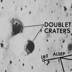
Left: Apollo 14 Site Traverses Chart LR3 and ALSEP are the locations of the laser retroreflector and surface experiment package.
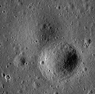
Right: Deconvolved and enhanced image by NASA/GSFC/ASU/GoneToPlaid – Homepage
Images
LPOD Photo Gallery Lunar Orbiter Images Apollo Images
Maps
(LAC zone 76B1) LAC map Geologic map LM map AIC map
Description
Wikipedia
(no Wikipedia page for Apollo 14's Doublet).
Additional Information
- IAU page: Doublet
Nomenclature
Astronaut-named feature, Apollo 14 site.
  Should not be confused with Double crater slightly southwest of LM Eagles landing site at the southern part of Mare Tranquillitatis ('Statio Tranquillitatis: mankind's very first manned lunar landing, the mission of Apollo 11, july 1969).
LPOD Articles
Bibliography
Alice J. Hall: APOLLO 14, the climb up Cone crater (National Geographic, July 1971).
  David M. Harland: EXPLORING THE MOON, the Apollo expeditions.
  Eric M. Jones: APOLLO LUNAR SURFACE JOURNAL (ALSJ).
Named Features -- Prev: Doppler -- Next: Douglass
This page has been edited 1 times. The last modification was made by - tychocrater tychocrater on Jun 13, 2009 3:24 pm - afx3u3

