Difference between revisions of "Cardanus"
| Line 3: | Line 3: | ||
{| class="wiki_table" | {| class="wiki_table" | ||
| | | | ||
| − | Lat: 13.2°N, Long: 72.5°W, Diam: 49 km, Depth: 3.44 km, [ | + | Lat: 13.2°N, Long: 72.5°W, Diam: 49 km, Depth: 3.44 km, [[R%C3%BCkl%2028|Rükl: 28]], [[Stratigraphy|Upper Imbrian]]<br /> |
|} | |} | ||
<div id="toc"> | <div id="toc"> | ||
| Line 11: | Line 11: | ||
[http://www.lpod.org/coppermine/thumbnails.php?album=search&type=full&search=Cardanus LPOD Photo Gallery] [http://www.lpi.usra.edu/resources/lunar_orbiter/bin/srch_nam.shtml?Cardanus%7C0 Lunar Orbiter Images]<br /> [http://www.mentallandscape.com/C_Zond07_A.jpg Zond 7] ('''Cardanus''' and environs, evening light).<br /> <br /> | [http://www.lpod.org/coppermine/thumbnails.php?album=search&type=full&search=Cardanus LPOD Photo Gallery] [http://www.lpi.usra.edu/resources/lunar_orbiter/bin/srch_nam.shtml?Cardanus%7C0 Lunar Orbiter Images]<br /> [http://www.mentallandscape.com/C_Zond07_A.jpg Zond 7] ('''Cardanus''' and environs, evening light).<br /> <br /> | ||
==Maps== | ==Maps== | ||
| − | ''([ | + | ''([[LAC%20zone|LAC zone]] 55B2)'' [http://planetarynames.wr.usgs.gov/images/Lunar/lac_55.pdf USGS Digital Atlas PDF]<br /> <br /> |
==Description== | ==Description== | ||
<br /> | <br /> | ||
==Description: Elger== | ==Description: Elger== | ||
| − | ''([ | + | ''([[IAU%20Directions|IAU Directions]])'' CARDANUS.--A fine regular ring-plain, about 32 miles in diameter, near the limb N. of [[Olbers|Olbers]]. Its bright walls, rising about 4,000 feet above the light grey floor, are clearly terraced, and exhibit, especially on the S.W., several spurs and buttresses. There is a fine valley on the outer E. slope, a large bright crater on the Mare just beyond its foot, and a conspicuous mountain in the same position farther north. I have not succeeded in seeing the faint central hill nor the crater N. of it shown by Schmidt, but there is a brilliant white circular spot on the floor at the inner foot of the N.W. wall which he does not show.<br /> <br /> |
==Description: Wikipedia== | ==Description: Wikipedia== | ||
[http://en.wikipedia.org/wiki/Cardanus_(crater) Cardanus]<br /> <br /> | [http://en.wikipedia.org/wiki/Cardanus_(crater) Cardanus]<br /> <br /> | ||
==Additional Information== | ==Additional Information== | ||
| − | * Depth data from [ | + | * Depth data from [[Kurt%20Fisher%20crater%20depths|Kurt Fisher database]] |
** Westfall, 2000: 3.44 km | ** Westfall, 2000: 3.44 km | ||
** Viscardy, 1985: 2.3 km | ** Viscardy, 1985: 2.3 km | ||
** Cherrington, 1969: 2.01 km | ** Cherrington, 1969: 2.01 km | ||
* Westfall's estimate of the depth is confirmed by measurements of the length of the shadows in [http://www.lpi.usra.edu/resources/lunarorbiter/frame/?4169 LO-IV-169H], which give results of 3200-3600 m (the shorter shadows reaching barely to the floor). The central peak is about 680 m tall. <span class="membersnap">- [http://www.wikispaces.com/user/view/JimMosher [[Image:JimMosher-lg.jpg|16px|JimMosher]]] [http://www.wikispaces.com/user/view/JimMosher JimMosher]</span> | * Westfall's estimate of the depth is confirmed by measurements of the length of the shadows in [http://www.lpi.usra.edu/resources/lunarorbiter/frame/?4169 LO-IV-169H], which give results of 3200-3600 m (the shorter shadows reaching barely to the floor). The central peak is about 680 m tall. <span class="membersnap">- [http://www.wikispaces.com/user/view/JimMosher [[Image:JimMosher-lg.jpg|16px|JimMosher]]] [http://www.wikispaces.com/user/view/JimMosher JimMosher]</span> | ||
| − | * TSI = 35, CPI = 10, FI = 25; MI =60 [ | + | * TSI = 35, CPI = 10, FI = 25; MI =60 [[Smith%20and%20Sanchez%2C%201973|Smith and Sanchez, 1973]] |
<br /> | <br /> | ||
==Nomenclature== | ==Nomenclature== | ||
Revision as of 14:43, 15 April 2018
Contents
Cardanus
|
Lat: 13.2°N, Long: 72.5°W, Diam: 49 km, Depth: 3.44 km, Rükl: 28, Upper Imbrian |
Table of Contents

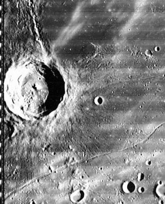
Lunar Orbiter IV 169-H2
Images
LPOD Photo Gallery Lunar Orbiter Images
Zond 7 (Cardanus and environs, evening light).
Maps
(LAC zone 55B2) USGS Digital Atlas PDF
Description
Description: Elger
(IAU Directions) CARDANUS.--A fine regular ring-plain, about 32 miles in diameter, near the limb N. of Olbers. Its bright walls, rising about 4,000 feet above the light grey floor, are clearly terraced, and exhibit, especially on the S.W., several spurs and buttresses. There is a fine valley on the outer E. slope, a large bright crater on the Mare just beyond its foot, and a conspicuous mountain in the same position farther north. I have not succeeded in seeing the faint central hill nor the crater N. of it shown by Schmidt, but there is a brilliant white circular spot on the floor at the inner foot of the N.W. wall which he does not show.
Description: Wikipedia
Additional Information
- Depth data from Kurt Fisher database
- Westfall, 2000: 3.44 km
- Viscardy, 1985: 2.3 km
- Cherrington, 1969: 2.01 km
- Westfall's estimate of the depth is confirmed by measurements of the length of the shadows in LO-IV-169H, which give results of 3200-3600 m (the shorter shadows reaching barely to the floor). The central peak is about 680 m tall. - JimMosher JimMosher
- TSI = 35, CPI = 10, FI = 25; MI =60 Smith and Sanchez, 1973
Nomenclature
Gerolamo Cardano (Cardanus) (September 24, 1501 - September 21, 1576) was a celebrated Italian Renaissance mathematician, physician, astrologer, and gambler. Today, he is best known for his achievements in algebra. He published the solutions to the cubic and quartic equations in his 1545 book Ars magna.
LPOD Articles
Astrophysicists Graveyard. Procellarum Twins
Bibliography
A Portfolio of Lunar Drawings (Harold Hill), pages 80, 81.
This page has been edited 1 times. The last modification was made by - tychocrater tychocrater on Jun 13, 2009 3:24 pm - afx3u2